Shakhtarsk Raion
| Shakhtarskyi Raion Шахтарський район | |||
|---|---|---|---|
| Raion | |||
| |||
 | |||
| Coordinates: 48°0′23″N 38°28′46.3″E / 48.00639°N 38.479528°ECoordinates: 48°0′23″N 38°28′46.3″E / 48.00639°N 38.479528°E | |||
| Country |
| ||
| Region | Donetsk Oblast | ||
| Established | 1965 | ||
| Admin. center | Shakhtarsk | ||
| Subdivisions |
List
| ||
| Government | |||
| • Governor | Dmytro Konakov | ||
| Area | |||
| • Total | 1,100 km2 (400 sq mi) | ||
| Population (2013) | |||
| • Total |
| ||
| Time zone | UTC+2 (EET) | ||
| • Summer (DST) | UTC+3 (EEST) | ||
| Postal index | 86200-86263 | ||
| Area code | +380 6255 | ||
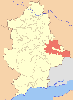
Shakhtarsk Raion (Ukrainian: Шахтарський район) is one of the 33 raions of Donetsk Oblast, located in eastern Ukraine. The administrative center of the raion is the city of Shakhtarsk, which is incorporated separately as a city of oblast significance and is not part of the raion. Population: 19,763 (2013 est.)[1].
Location
Shakhtarsk Raion is located in the eastern part of Donetsk Oblast and at its southeast it has an international border along with Rostov Oblast of Russian Federation. To its east raion borders Luhansk Oblast.
To the south of Shakhtarsk Raion is located Amvrosiivka Raion, while to its north – Bakhmut Raion. To the west of Shakhtars Raion stretches a chain of several cities with separate regional-level self-government such as Makiivka, Khartsyzk, Yenakieve, Zhdanivka. Raion also completely surrounds such cities like Shakhtarsk, Torez, Snizhne.
War in Donbass
Shakhtarsk Raion has one international border crossing with the Russian Federation, Marynivka - Kuibyshevo. On June 5, 2014 the Government of Ukraine was forced to close the border crossing, due to multiple reports of unsanctioned crossing of it by militants from the Russian Federation. On June 6, 2014 an intense fighting erupted at the Marynivka border checkpoint between the Ukrainian Border Troops and militants who tried to cross into Ukraine from the Russian Federation.
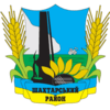
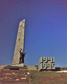
During the War in Donbass around the Savur-Mohyla height took place several battles. The obelisk of the Savur-Mohyla Soviet memorial is depicted on the coat of arms and flag of Shakhtarsk Raion.
The Malaysia Airlines Flight 17, remnants of which scattered around the village of Hrabove, went down within the area of the raion.
On August 10–11, 2014 Ukrainian media claimed that the village of Stepanivka was completely destroyed by the multi-rocket launcher systems BM-21 Grad that were fired from the territory of the Russian Federation.[2]
Demographics
As of the 2001 Ukrainian Census, the majority of residents are ethnic Ukrainians and speak Ukrainian as their first language:[3][4]
| Ethnicity | ||
| Ukrainians | 18,042 | 74.4% |
| Russians | 5,663 | 23.3% |
| Belarusians | 249 | 1.0% |
| Language | |
| Ukrainian | 53.36% |
| Russian | 46.25% |
| Belarusian | 0.12% |
| Armenian | 0.06% |
References
- ↑ "Чисельність наявного населення України (Actual population of Ukraine)" (in Ukrainian). State Statistics Service of Ukraine. Retrieved 21 January 2015.
- ↑ "Russian "Grads" completely destroyed Ukrainian village in Donetsk region". August 11, 2014. Archived from the original on August 12, 2014. Retrieved August 27, 2014.
- ↑
- ↑ "Національний склад та рідна мова населення Донецької області" [Ethnic and linguistic composition of Donetsk Oblast] (in Ukrainian). Archived from the original on 27 November 2012.
| Villages | Chervona Zorya • Chuhuno-Krepynka • Dibrivka • Dmytrivka • Dubivka • Dymytrova • Hrabove • Komyshatka • Krasnyi Luch • Kruhlyk • Latysheve • Maloorlivka • Manuilivka • Marynivka • Mykhailivka • Nikishyne • Novomykolaivka • Novoorlivka • Novopelahiivka • Orlovo-Ivanivka • Perederieve • Petrivske • Petropavlivka • Rivne • Rozivka • Rozsypne (Dmytrivka) • Rozsypne • Saurivka • Shaposhnykove • Shevchenko (Maloorlivka) • Shevchenko (Rozovskyi) •Stepanivka • Stizhkove • Stryukove • Tarany • Ternove • Tymofiyivka • Velyka Shyshivka • Verkhnyi Kut • Vesele • Zolotarivka • Zrubne | |
|---|---|---|
| Rural settlements | Balochne • Kozhevnia • Kumshatske • Molodetske • Polyove • Ridkodub • Sadove • Slavne • Stepne• Zachativka • Zakharchenko • Zaroshchenske | |
| Raions | |||||
|---|---|---|---|---|---|
| Cities |
| ||||
| |||||