Novoazovsk Raion
| Novoazovsk Raion Новоазовський район | |||
|---|---|---|---|
| Raion | |||
| |||
 | |||
| Coordinates: 47°06′42″N 38°04′57″E / 47.11167°N 38.08250°ECoordinates: 47°06′42″N 38°04′57″E / 47.11167°N 38.08250°E | |||
| Country |
| ||
| Region | Donetsk Oblast | ||
| Established | N/A | ||
| Admin. center |
Novoazovsk (de jure) Vynohradne (de facto)[1][2] | ||
| Subdivisions |
List
| ||
| Government | |||
| • Governor | N/A | ||
| Area | |||
| • Total | 818.612 km2 (316.068 sq mi) | ||
| Population | |||
| • Total | 35,737 | ||
| • Density | 44/km2 (110/sq mi) | ||
| Time zone | UTC+2 (EET) | ||
| • Summer (DST) | UTC+3 (EEST) | ||
| Postal index | 876-XX | ||
| Area code | 380 | ||
| Website | Novoazovskiy raion portal | ||

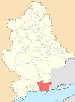
The Novoazovsk Raion (Ukrainian: Новоазовський район, Novoazovs'kyi raion; Russian: Новоазовский район, Novoazovskiy raion) is one of the 18 administrative raions (a district) of Donetsk Oblast in eastern Ukraine. Its administrative center is located in the city of Novoazovsk, and its southern portion borders the Azov Sea. Population: 35,737 (2013 est.)[3]
Location and division
Novoazovsk Raion borders the city of Mariupol (Illich and Ordzhonikidze raions of Mariupol) to its west and has the international Russia-Ukraine border to its east. To its northwest, Novoazovsk Raion shares borders with Volodarske Raion. To its north Novoazovsk Raion borders Telmanove Raion.
The raion is divided into 15 municipal councils: one city municipality, one town municipality and 13 - rural councils.[4] Within Novoazovsk Raion there are one city, Novoazovsk, one urban-type settlement (Sedovo), 9 selsovets, and 59 small settlements. Also included within the raion are 14 industrial organizations, 4 construction and transport organizations, 9 kolhozy, 5 sovhozy, 3 fisheries cooperatives (rybkolhozy), 5 industrial organizations, 4 construction companies, 35 medical schools, 27 resort areas, and 26 libraries.
History
Before the defeat of the Don Republic by the Red Army in 1920, the territory of the Novoazovsk Raion was part of the Taganrog Okrug of the Don Republic. In April of the same year, the territory as the Taganrog Raion was ceded to the newly organaized Donetsk Governorate.
In the beginning of 1923, the Novo-Mykolayivka Raion was organized. On September 22, 1923, the administrative center of the Novo-Mykolayivka Raion, Novo-Mykolayivka, was renamed Budyonivka, and the Raion became Budyonivka Raion.In 1958, the Budyonivka Raion was again renamed, becoming the Novoazovsk Raion, and its administrative center was renamed Novoazovsk.
Within the Novoazovsk Raion, were born the: Arctic explorer Georgy Sedov, the general-polkovnik Hero of the Soviet Union I. Lyudnikov, poet N. Scherbina, and the sculptor N. Yasinenko.
On 9 December 2014, the Verkhovna Rada, Ukraine's national parliament, changed the boundaries and total area of the Novoazovsk Raion to encompass 818.612 km2 (316.068 sq mi). The district's administration buildings and government was moved to the Vynohradne urban-type settlement following the events surrounding the War in Donbass.[1][2]
Demographics
According to the 2001 Ukrainian Census:[5]
| Ethnicity | ||
| Ukrainians | 26,123 | 67.2% |
| Russians | 11,494 | 29.5% |
| Greeks | 389 | 1.0% |
| Belarusians | 208 | 0.5% |
| Germans | 182 | 0.5% |
Environment
- The nature preserve Khomytovs'ka steppe or Khomutovskyy steppe[6] (Ukrainian: Хомуто́вський степ, Russian: Хомутовская степь), part of the Ukrainian steppe National Park, is a nature preserve located within the oblast'. Having an area is 10.28 km², the preserve consists of many different types of flora. It is currently listed in the UNESCO list of natural monuments.
- The regional park Meotyda (Ukrainian: Меотида, Russian: Меотида) is a natural park with a total area of 130.17 km². The park contains over 640 different types of rare and unique flora, 15 of which are listed in the Ukraine's Red Book of Rare Species.
Settlements
- Sjedove (Ukrainian: Сєдове; Russian: Седово; formerly: Kryva Kosa) is an urban-type settlements (townlet) with a population of 2,770. Formerly a kolhoz by the name of Zavet Il'icha, the urban-type settlement now consists of the Kholodne and Obryv settlements.
- Bezimenne (Ukrainian: Безіменне; Russian: Безыменное; literally: No-name) is a village (selo) with a population of 2,529. It used to be known as the Druzhba Narodiv kolhoz. The village now consists of the following settlements: Vedens'ke, Vesele, Kachkars'ke, Mitkogo-Kacharki, Pavlovs'ke, Patriotychne, and Roza.
- Vynohradne (Ukrainian: Виноградне; Russian: Виноградное) is a village (selo) with a population of 1,856. Formerly known as the Rodyna kolhoz, it now consists of the Pioners'ke, Prymors'ke, and Kalynovka settlements.
- Kominternove (Ukrainian: Комінтернове; Russian: Коминтерново) is a village (selo) with a population of 494. It used to be known as the Ohorodnyi kolhoz. The village now consists of the Dzerzhyns'ke, Zaichenko, Leninske, Nova Tavria, and Novobydogo settlements.
- Krasnoarmiis'ke (Ukrainian: Красноармійське; Russian: Красноармейское) is a village (selo) with a population of 1,191. Formerly known as the Zaria Komunyzna kolhoz, the village now consists of the Kozats'ke, Kulykogo, Oktyabr, Porokhnia, and Shevchenko settlements.

- Pavlopil' (Russian: Павлопіль; Russian: Павлополь) is a village (selo) with a population of 615. Formerly known as the Avantgarde kolhoz, it now consists of the Pyschevyk and Chernenko settlements.
- Prymors'ke (Ukrainian: Приморське; Russian: Приморское) is a village (selo) with a population of 1,495. It used to be known as the Prymors'kyi kolhoz. The village now consists of the Naverezhne, Sosnovs'ke, Pervomais'ke, and Ukrains'ke settlements.
- Samilove (Ukrainian: Самійлове; Russian: Самойлово) is a village (selo) with a population of 536. Formerly known as the Mayak kolhoz, the village now consists of the Klynykyno, Vanuashkyno, Kovs'ke, Kuznetsy, Markyno, Peremozhne, and Scherbak settlements.
- Khomutove (Ukrainian: Хомутове; Russian: Хомутово) is a village (selo) with a population of 760. It wused to be known as the kolhoz by the name of Lenin. The village now consists of the following settlements: Bessarabka, Vytava, Rozy Liuksemburh, and Sedogo-Vasyl'evla.
- Shyrokyne (Ukrainian: Широкине; Russian: Широкино) is a settlement with a population of 1,347. Formerly known as the kolhoz by the name of 21st Convention of the CPSU, the settlement now consists of the following settlements: Berdians'ke, Lebedyns'ke, Sakhanka, and Sopyno.
See also
References
- 1 2 Laws of Ukraine. Verkhovna Rada of Ukraine No. 32-VIII: Про зміни в адміністративно-територіальному устрої Донецької області, зміну і встановлення меж Волноваського, Новоазовського та Тельманівського районів Донецької області (On the changes in the administrative and territorial structure of Donetsk Oblast, changing and defining the boundaries of the Volnovakha, Novoazovsk and Telmanove Raions of Donetsk Oblast). Adopted on 11 December 2014. (Ukrainian)
- 1 2 "In the Donetsk Oblast three district centers removed from the territory seized by militants". Ukrayinska Pravda (in Ukrainian). 8 December 2014. Retrieved 31 December 2014.
- ↑ "Чисельність наявного населення України (Actual population of Ukraine)" (in Ukrainian). State Statistics Service of Ukraine. Retrieved 21 January 2015.
- ↑ Novoazovsk Raion at the Verkhovna Rada website
- ↑ "Національний склад та рідна мова населення Донецької області" [Ethnic and linguistic composition of Donetsk Oblast] (in Ukrainian). Archived from the original on 27 November 2012.
- ↑ See also: (in Russian) geocaching.su - Khomytovs'ka steppe website
External links
- (in Ukrainian) Verkhovna Rada website - Administrative divisions of the Amvrosiivsky Raion
| Raions | |||||
|---|---|---|---|---|---|
| Cities |
| ||||
| |||||