Mount St. Helens National Volcanic Monument
| Mount St. Helens National Volcanic Monument | |
|---|---|
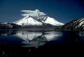 Spirit Lake and Mount St. Helens, seen in 1982 | |
  | |
| Location | Skamania / Cowlitz / Lewis counties, Washington, United States |
| Nearest city | Castle Rock, Washington |
| Coordinates | 46°13′59″N 122°11′04″W / 46.2331657°N 122.1845412°WCoordinates: 46°13′59″N 122°11′04″W / 46.2331657°N 122.1845412°W[1] |
| Area | 110,000 acres (450 km2) |
| Created | August 26, 1982 |
| Governing body | U.S. Forest Service |
| Website | Mount St. Helens National Volcanic Monument |
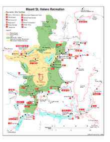
Mount St. Helens National Volcanic Monument is a U.S. National Monument that includes the area around Mount St. Helens in Washington. It was established on August 27, 1982 by U.S. President Ronald Reagan following the 1980 eruption.[2] The 110,000 acre (445 km2) National Volcanic Monument was set aside for research, recreation, and education. Inside the Monument, the environment is left to respond naturally to the disturbance.[3]
Mount St. Helens National Volcanic Monument was the United States' first such monument managed by the U.S. Forest Service. At dedication ceremonies on May 18, 1983, Max Peterson, head of the USFS, said, "we can take pride in having preserved the unique episode of natural history for future generations." Since then, many trails, viewpoints, information stations, campgrounds, and picnic areas have been established to accommodate the increasing number of visitors each year.[2]
Beginning in 1983, visitors have been able to drive to Windy Ridge, only 4 miles (6.4 km) northeast of the crater.
Mountain climbing to the summit of the volcano has been allowed since 1986.[2]
Mount St. Helens Visitor Center at Silver Lake
The Mount St. Helens Visitor Center at Silver Lake, about 30 miles (48 km) west of Mount St. Helens and five miles (8 km) east of Interstate 5 (outside the monument), opened in 1987 and has been operated by the Washington State Park System since October 2000.[4] Exhibits include the area's culture and history, and the natural history and geology of the volcano and the eruption, including the recovery of the area's vegetation and animal life. The Center includes a theater, a gift shop and outdoor trails. By the end of 1989, the Center had hosted more than 1.5 million visitors. A small admission fee is charged.
The Center was formerly operated by the U.S. Forest Service.
Johnston Ridge Observatory
The Johnston Ridge Observatory is located 52 miles (84 km) east of Castle Rock, Washington, at the end of Washington State Route 504, four miles from the mountain. Exhibits focus on the geologic history of the volcano, eyewitness accounts of the explosion, and the science of monitoring volcanic activity. Two movies and ranger-led programs are available every hour. A half-mile paved trail provides views of the lava dome, crater, pumice plain, and landslide deposit, with access to hiking trails in the restricted area.
The observatory is located near the site of volcanologist David A. Johnston's camp on the morning of May 18, 1980, and opened in 1993.
Science and Learning Center at Coldwater
The Coldwater Ridge Visitor Center in the Coldwater Lake area opened in 1993, operated by the Forest Service, but closed in November 2007 due to a lack of funding.[5]
The center reopened as the Science and Learning Center at Coldwater in May 2013, operating as an educational facility and conference center in cooperation with the Mount St. Helens Institute.[6] It is open to the public on weekends from 10am to 6pm. Many of the exhibits have been removed, but the gift shop, theatre, and some signage still exist.
The Winds of Change Trail #232, a short, barrier-free interpretive trail, departs from the Science and Learning Center.
South and east sides of Mount St. Helens
The southern and eastern sides of Mount St. Helens are accessible only by U.S. Forest Service roads. The main roads are:


Bear Meadows
Bear Meadows is an alpine meadow and viewpoint northeast of Mt. St. Helens. It is located on U.S. Forest Service Road 99. Gary Rosenquist camped here with friends on May 17–18, 1980. He started taking his famous eruption photographs from this location. The sequence of eruption photos show give a time lapse view of the developing eruption. As the lateral blast developed, he and his friends abandoned their campsite fearing for their lives. He continued taking photos as they escaped in a car. The eruption's lateral blast narrowly missed the site as it was deflected by a ridge just west of the meadow. In an interview with KIRO-TV in 1990, a friend called that ridge "the line of death."
Windy Ridge
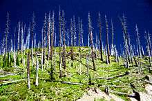
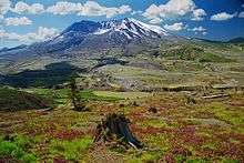
Windy Ridge is the closest view point accessible to the general public. Beginning in the summer of 1983, visitors have been able to drive to Windy Ridge, on U.S. Forest Service Road 99, only 4 miles (6.4 km) northeast of the crater. From this vantage point overlooking Spirit Lake, people see firsthand not only the evidence of a volcano's destruction, but also the remarkable, gradual (but faster than originally predicted) recovery of the land as revegetation proceeds and wildlife returns.
References
- ↑ "Mount St Helens National Volcanic Monument". Geographic Names Information System. United States Geological Survey. Retrieved 2016-01-19.
- 1 2 3 Tilling; Topinka, and Swanson (1990). Eruptions of Mount St. Helens: Past, Present, and Future.
- ↑ "Welcome". Mount St. Helens National Volcanic Monument. United States Forest Service. Retrieved 2007-09-15.
- ↑ "Mount St. Helens Visitor Center". Washington State Parks. Retrieved 2016-01-19.
- ↑ "St. Helens' Coldwater Ridge visitor center closing". KOMOnews.com. 2007-10-22. Archived from the original on 2014-08-10. Retrieved 2016-01-19.
- ↑ "Science and Learning Center at Coldwater". Mount St. Helens Institute. Archived from the original on 2014-08-11. Retrieved 2014-08-07.
External links
| Wikimedia Commons has media related to Mount St. Helens National Volcanic Monument. |
- Mount St. Helens National Volcanic Monument – official U.S. Forest Service site
- Mount St. Helens Visitor Center at Silver Lake – official Washington State Parks site
- Mount St. Helens National Volcanic Monument – Visit a Volcano, includes maps and volcano information
- Travel information about Mount St. Helens National Volcanic Monument
- Johnston Ridge Observatory
| Topics | |
|---|---|
| Lists by states |
|
| Lists by insular areas | |
| Lists by associated states | |
| Other areas | |
| |