Sun Lakes-Dry Falls State Park
| Sun Lakes-Dry Falls State Park | |
| Washington State Park | |
 | |
| Country | United States |
|---|---|
| State | Washington |
| County | Grant |
| Elevation | 1,270 ft (387 m) [1] |
| Coordinates | 47°35′41″N 119°21′55″W / 47.59472°N 119.36528°WCoordinates: 47°35′41″N 119°21′55″W / 47.59472°N 119.36528°W [1] |
| Area | 3,774 acres (1,527 ha) |
| Established | 1933 |
| Management | Washington State Parks and Recreation Commission |
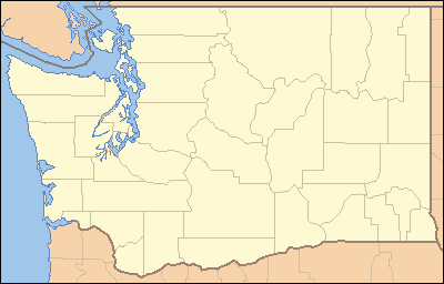 Location in the state of Washington | |
| Website: Sun Lakes-Dry Falls State Park | |
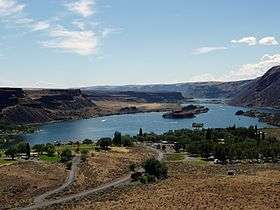
Sun Lakes-Dry Falls State Park (formerly called Sun Lakes State Park) is a public recreation area located at the foot of Dry Falls, three miles west of Coulee City in Grant County, Washington. The state park covers 3,774 acres (1,527 ha) along Route 17 at the head of the Lower Grand Coulee.[2] A privately owned golf course and resort, Sun Lakes Park Resort, is located near the park entrance and Park Lake.[3] The park is also home to the Camp Delany group retreat facility.[4]
Dry Falls is the site of a waterfall formed during the Missoula Floods which was ten times the size of Niagara Falls. It is now a stark cliff measuring 400 feet (120 m) high and 3.5 miles (5.6 km) wide. The cliff overlooks a desert oasis filled with lakes and abundant wildlife.[2] It is a prime example of shrub-steppe habitat.
Park history
The state purchased land to create the state park from 1933 through 1972. Fifteen parcels were purchased from the Bureau of Land Management, the Department of Natural Resources, and private interests. The Civilian Conservation Corps built rock walls and a lookout at Dry Falls called Vista House in 1938. The CCC workers also constructed a residence and water pump house. Camp Delany was added to the park in 1956, the buildings at Sun Lakes Park Resort were constructed in 1959, and the interpretive center overlooking Dry Falls was built in 1965.[3]
Activities and amenities
The park has 73,640 feet (22,450 m) of lake shoreline and offers fishing, swimming, boating, hiking, and golf. The park's interpretive center offers exhibits on area geology.[2]

Umatilla Rock Trail trailhead is located near the southwest portion of the rock, accessible via a dirt road from the main portion of the park. This hiking trail navigates the outer circumference of the rock and consists of 5.0 miles, roundtrip.[5] There is also an alternate section which cuts up and over a notch located on the northeast portion of the rock.
Umatilla Rock is a large basalt rock which resisted being eroded by the Great Floods.[6] Its location is downstream of the falls and upstream of the main park and resort. Nearby lakes include Dry Falls, Perch, Red Alkali, Green Alkali, and Meadow.[7]
References
- 1 2 "Sun Lakes State Park". Geographic Names Information System. United States Geological Survey.
- 1 2 3 "Sun Lakes-Dry Falls State Park". Washington State Parks and Recreation Commission. Retrieved August 22, 2018.
- 1 2 Brae, Heron J. (January 21, 2011). "A Floristic Study of Sun Lakes State Park in Eastern Washington" (PDF). Evergreen State College. p. 7. Retrieved August 22, 2018.
- ↑ "Camp Delany at Sun Lakes-Dry Falls State Park". Washington State Parks and Recreation Commission. Retrieved August 22, 2018.
- ↑ "Sun Lakes-Dry Falls State Park - Umatilla Rock via Monument Coulee — Washington Trails Association". www.wta.org. Retrieved 2018-09-09.
- ↑ Kirsten., Peters, E. (2001). Geology from experience : hands-on labs and problems in physical geology. Davis, Larry E. (Larry Eugene). New York: W.H. Freeman and Co. ISBN 0716731452. OCLC 44683589.
- ↑ "Sun Lakes-Dry Falls State Park Overview". parks.state.wa.us. Retrieved 09/09/2018. Check date values in:
|access-date=(help)
External links
| Wikimedia Commons has media related to Sun Lakes — Dry Falls State Park. |
| Wikivoyage has a travel guide for Sun Lakes-Dry Falls State Park. |
- Sun Lakes-Dry Falls State Park Washington State Parks and Recreation Commission
- Sun Lakes-Dry Falls State Park Map Washington State Parks and Recreation Commission