Sunset Crater
| Sunset Crater | |
|---|---|
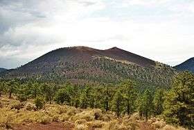 Sunset Crater from the Cinder Hills | |
| Highest point | |
| Elevation | 8,042 ft (2,451 m) NAVD 88[1] |
| Prominence | 999 ft (304 m) [2] |
| Coordinates | 35°21′56″N 111°30′02″W / 35.365579283°N 111.500652017°WCoordinates: 35°21′56″N 111°30′02″W / 35.365579283°N 111.500652017°W [1] |
| Geography | |
 Sunset Crater | |
| Location | Coconino County, Arizona, U.S. |
| Topo map | USGS Sunset Crater East |
| Geology | |
| Age of rock | ~950 years |
| Mountain type | Cinder cone[3] |
| Volcanic field | San Francisco volcanic field |
| Last eruption | 1075 ± 25 years[3] |
| Climbing | |
| Easiest route | Hike |
| Sunset Crater Volcano National Monument | |
|---|---|
|
IUCN category III (natural monument or feature) | |
 | |
| Nearest city | Flagstaff, AZ |
| Coordinates | 35°21′56″N 111°30′02″W / 35.365579283°N 111.500652017°W |
| Area | 3,040 acres (12.3 km2)[4] |
| Established | May 26, 1930 |
| Visitors | 60,233 (in 2017)[5] |
| Governing body | National Park Service |
| Website | Sunset Crater Volcano National Monument |

Sunset Crater is a cinder cone located north of Flagstaff in U.S. State of Arizona. The crater is within the Sunset Crater Volcano National Monument.
Sunset Crater is the youngest in a string of volcanoes (the San Francisco volcanic field) that is related to the nearby San Francisco Peaks.[6]
Formation
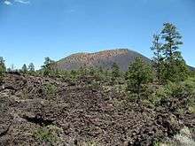
The date of the eruptions that formed the 340-meter-high cone (1,120 ft) was initially derived from tree-ring dates, suggesting the eruption began between the growing seasons of A.D. 1064–1065.[7] However, more recent geologic and archaeological evidence places the eruption around A.D. 1085.[8] The largest vent of the eruption, Sunset Crater itself, was the source of the Bonito and Kana-a lava flows that extended about 2.5 kilometers (1.6 mi) NW and 9.6 kilometers (6 mi) NE, respectively. Additional vents along a 10-kilometer-long fissure (6.2 mi) extending SE produced small spatter ramparts and a 6.4-kilometer-long lava flow (4 mi) to the east. The Sunset Crater eruption produced a blanket of ash and lapilli covering an area of more than 2,100 square kilometers (810 sq mi) and forced the temporary abandonment of settlements of the local Sinagua people.[3] The volcano has partially revegetated, with pines and wildflowers. The crater is the namesake for the Sunset Crater Beardtongue (Penstemon clutei). While the volcano is not anticipated to erupt again, despite its young geologic age, the San Francisco volcanic field is still considered active, and a future eruption elsewhere in the area is a statistical certainty.
Damage from hikers forced the National Park Service to close a trail leading to the crater, but a short trail at the base remains.[9]
The hiking trail below the summit skirts the substantial Bonito Lava Flow. This hardened lava is black and appears fresh as it has devastated the forest in its path. The lava flow also created an ice cave or tube that is now closed to the public after a partial collapse.
2015 eruption scare
On June 5, 2015, a website with satellite images reported steam rising from the crater, leading to fears that Sunset Crater was erupting. The cause of the steam was later determined to be a forest fire, and geologists stated that the volcano was extinct.[10]
Sunset Crater Volcano National Monument
Sunset Crater Volcano National Monument is a U.S. National Monument in the north-central part of the U.S. state of Arizona, created to protect Sunset Crater, a cinder cone within the San Francisco Volcanic Field.[11] The monument is managed by the National Park Service in close conjunction with nearby Wupatki National Monument. In 1928, a Hollywood film company - Famous Players-Lasky Corporation - planned to detonate large quantities of explosives on the side of Sunset Crater in order to create an avalanche for Zane Grey's motion picture, Avalanche.[12] Public outcry over this plan led in part to the proclamation of Sunset Crater Volcano National Monument by President Herbert Hoover in 1930.[13]
A 1-mile (1.6 km), self-guided loop trail is located at the base of Sunset Crater, but hiking to the summit is not permitted. A trail providing access to the summit and crater was closed in 1973 because of excessive erosion caused by hikers.[14] A visitor center is located near the park entrance, 15 miles (24 km) north of Flagstaff, Arizona, along U.S. Highway 89.
References
- 1 2 "Sunset Crater". NGS data sheet. U.S. National Geodetic Survey. Retrieved December 23, 2008.
- ↑ "Sunset Crater, Arizona". Peakbagger.com. Retrieved August 19, 2016.
- 1 2 3 "Sunset Crater". Global Volcanism Program. Smithsonian Institution. Retrieved December 23, 2008.
- ↑ "Listing of acreage as of December 31, 2011". Land Resource Division, National Park Service. Retrieved December 30, 2011.
- ↑ "NPS Annual Recreation Visits Report". National Park Service. Retrieved October 19, 2017.
- ↑ Priest, Susan S.; Wendell A. Duffield; Karen Malis-Clark; James W. Hendley II; Peter H. Stauffer (December 21, 2001). "The San Francisco Volcanic Field, Arizona - U.S. Geological Survey Fact Sheet 017-01". United States Geological Survey. Archived from the original on April 21, 2008. Retrieved August 12, 2008.
- ↑ Pilles, Peter J. Jr. (1979). "Sunset Crater and the Sinagua: A New Interpretation". In Sheets, Payson D.; Grayson, Donald K. Volcanic Activity and Human Ecology. New York: Academic Press. pp. 459–485.
- ↑ Elson, Mark D.; Ort, Michael H.; Sheppard, Paul R.; Samples, Terry L.; Anderson, Kirk C.; May, Elizabeth M. (2011). A.D. 1064 No More? A Multidisciplinary Re-evaluation of the Date of the Eruption of Sunset Crater Volcano, Northern Arizona (PDF). 76th Annual Meeting of the Society for American Archaeology. Sacramento, California.
- ↑ "Lava Flow Trail". Sunset Crater Volcano National Monument. National Park Service. September 14, 2006. Retrieved August 12, 2008.
- ↑ "Despite rumors, Arizona's Sunset Crater Volcano remains extinct". The Arizona Republic. June 5, 2015.
- ↑ "Sunset Crater Volcano National Monument". National Park Service. September 14, 2007. Retrieved August 12, 2008.
- ↑ "America's Best Idea: Sunset Crater nearly destroyed by Hollywood". KNAU, NPR. October 2, 2009.
- ↑ "Sunset Crater Volcano National Monument - People". National Park Service. March 20, 2007. Retrieved January 27, 2012.
- ↑ "Frequently Asked Questions". National Park Service. Retrieved June 18, 2011.
External links
| Wikimedia Commons has media related to Sunset Crater Volcano. |
- Official National Park Service Sunset Crater National Monument website
- Geology of Sunset Crater - USGS