Chiricahua National Monument
| Chiricahua National Monument | |
|---|---|
|
IUCN category V (protected landscape/seascape) | |
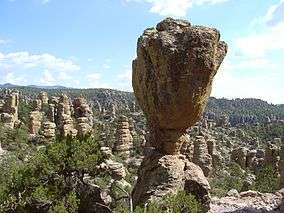 The Balanced Rock formation | |
 Location in the United States  Location in Arizona | |
| Location | Cochise County, Arizona, United States |
| Nearest city | Willcox, Arizona |
| Coordinates | 32°00′20″N 109°21′24″W / 32.00569°N 109.35672°WCoordinates: 32°00′20″N 109°21′24″W / 32.00569°N 109.35672°W |
| Area | 11,984 acres (48.50 km2)[1] |
| Created | April 18, 1924 |
| Visitors | 51,277 (in 2016)[2] |
| Governing body | National Park Service |
| Website | Chiricahua National Monument |
Chiricahua National Monument is a unit of the National Park System located in the Chiricahua Mountains of southeastern Arizona. The monument was established on April 18, 1924, to protect its extensive hoodoos and balancing rocks. The Faraway Ranch, which was owned at one time by Swedish immigrants Neil and Emma Erickson, is also preserved within the monument.[3]
Visitor center
A visitor center is located two miles from the entrance to Chiricahua National Monument. The visitor center has exhibits relating to the geology, natural history, and cultural history of the area. A park ranger is available to provide visitors with trail guides and information. Approximately 17 mi (27 km) of trails lead hikers through various ecosystems of meadows, forests, and rock formations.
The visitor center has a free shuttle that leaves each morning at 9:00am. The shuttle takes hikers to the Echo Canyon or Massai Point trailheads. Hikers return to the visitor center by following the designated trails.[4]
Geology
Located approximately 36 miles (58 km) southeast of Willcox, Arizona, the monument preserves the remains of an immense volcanic eruption that shook the region about 27 million years ago. The thick, white-hot ash spewed forth from the nearby Turkey Creek Caldera, cooled and hardened into rhyolitic tuff, laying down almost 2,000 ft (610 m) of highly siliceous, dark volcanic ash and pumice. The volcanic material eventually eroded into the natural rock formations of the present monument.[5]
In 2008, the Chiricahua National Monument Historic Designed Landscape, covering roughly 80% of the national monument, was listed on the National Register of Historic Places.[6]
Missing naturalist
On January 13, 1980, Paul Fugate, a National Park Service naturalist and law enforcement ranger, disappeared after leaving the monument headquarters while in uniform, to check trails leading to the recently acquired Faraway Ranch. An acquaintance claimed to have seen him later that afternoon, slumped between two men in a pickup truck. Despite an extensive search of the rugged 17 sq mi (44 km2) monument area by authorities and search and rescue teams, no trace of him has been found.[7][8]
Gallery
 Park map
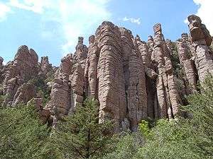 Stone columns, called hoodoos, are the most common formation in the monument
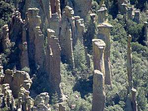 Hoodoos in Totem Canyon
 The Big Balanced Rock
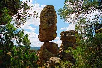 Pinnacle Balanced Rock - Heart of Rocks Loop trail
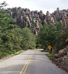 Park road

Climate
| Climate data for Chiricahua National Monument, AZ | |||||||||||||
|---|---|---|---|---|---|---|---|---|---|---|---|---|---|
| Month | Jan | Feb | Mar | Apr | May | Jun | Jul | Aug | Sep | Oct | Nov | Dec | Year |
| Record high °F (°C) | 80 (27) |
80 (27) |
86 (30) |
93 (34) |
104 (40) |
108 (42) |
109 (43) |
103 (39) |
100 (38) |
95 (35) |
85 (29) |
82 (28) |
109 (43) |
| Average high °F (°C) | 56.2 (13.4) |
59.1 (15.1) |
64.7 (18.2) |
72.8 (22.7) |
81.5 (27.5) |
90.5 (32.5) |
89.2 (31.8) |
86.1 (30.1) |
83.5 (28.6) |
75.2 (24) |
64.1 (17.8) |
56.7 (13.7) |
73.3 (23) |
| Average low °F (°C) | 29.9 (−1.2) |
31.2 (−0.4) |
34.4 (1.3) |
39.4 (4.1) |
46.2 (7.9) |
55.2 (12.9) |
59.9 (15.5) |
58.9 (14.9) |
55.0 (12.8) |
45.9 (7.7) |
35.7 (2.1) |
30.2 (−1) |
43.5 (6.4) |
| Record low °F (°C) | −10 (−23) |
8 (−13) |
10 (−12) |
20 (−7) |
19 (−7) |
35 (2) |
40 (4) |
44 (7) |
33 (1) |
21 (−6) |
8 (−13) |
−1 (−18) |
−10 (−23) |
| Average precipitation inches (mm) | 1.45 (36.8) |
1.20 (30.5) |
1.17 (29.7) |
0.47 (11.9) |
0.34 (8.6) |
0.84 (21.3) |
4.00 (101.6) |
4.05 (102.9) |
1.70 (43.2) |
1.17 (29.7) |
1.03 (26.2) |
1.61 (40.9) |
19.03 (483.3) |
| Average snowfall inches (cm) | 2.9 (7.4) |
1.7 (4.3) |
1.7 (4.3) |
0.3 (0.8) |
0 (0) |
0 (0) |
0 (0) |
0 (0) |
0 (0) |
0.1 (0.3) |
0.7 (1.8) |
2.9 (7.4) |
10.3 (26.3) |
| Source: https://wrcc.dri.edu/cgi-bin/cliMAIN.pl?az1664 | |||||||||||||
See also
![]()
References
- ↑ "Listing of acreage as of December 31, 2013". Land Resource Division, National Park Service. Retrieved 2014-03-28.
- ↑ "NPS Annual Recreation Visits Report". National Park Service. Retrieved 2017-08-07.
- ↑ "Chiricahua National Monument: Nature & Science". National Park Service. Retrieved 2011-07-03.
- ↑ "Chiricahua National Monument (U.S. National Park Service)". www.nps.gov. Retrieved 16 April 2018.
- ↑ "Geology Field Notes: Chiricahua National Monument, Arizona". National Park Service. Retrieved 2011-07-03.
- ↑ National Park Service (2009-03-13). "National Register Information System". National Register of Historic Places. National Park Service.
- ↑ "The Mystery of a Missing Naturalist May Lead to Legal Test of Dismissal". New York Times. August 16, 1981. p. 63. Retrieved May 20, 2018.
- ↑ Smith, Rick (March 5, 2009). "Where in the World is Paul Fugate?". National Parks Traveler. nationalparkstraveler.org. Retrieved May 20, 2018.
External links
| Wikivoyage has a travel guide for Chiricahua National Monument. |

- Chiricahua National Monument - National Park Service
| Topics | |
|---|---|
| Lists by states |
|
| Lists by insular areas | |
| Lists by associated states | |
| Other areas | |
| |