Montval-sur-Loir
| Montval-sur-Loir | |
|---|---|
| Commune | |
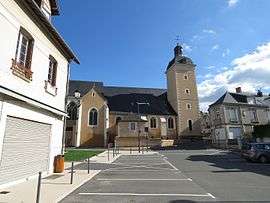 The church in Château-du-Loir | |
 Montval-sur-Loir Location within Pays de la Loire region  Montval-sur-Loir | |
| Coordinates: 47°41′42″N 0°25′05″E / 47.695°N 0.418°ECoordinates: 47°41′42″N 0°25′05″E / 47.695°N 0.418°E | |
| Country | France |
| Region | Pays de la Loire |
| Department | Sarthe |
| Arrondissement | La Flèche |
| Canton | Château-du-Loir |
| Intercommunality | Loir-Lucé-Bercé |
| Area1 | 26.99 km2 (10.42 sq mi) |
| Population (2014)2 | 6,236 |
| • Density | 230/km2 (600/sq mi) |
| Time zone | UTC+1 (CET) |
| • Summer (DST) | UTC+2 (CEST) |
| INSEE/Postal code | 72071 /72500 |
|
1 French Land Register data, which excludes lakes, ponds, glaciers > 1 km2 (0.386 sq mi or 247 acres) and river estuaries. 2 Population without double counting: residents of multiple communes (e.g., students and military personnel) only counted once. | |
Montval-sur-Loir is a commune in the Sarthe department in the region of Pays de la Loire in north-western France. The municipality was established on 1 October 2016 and consists of the former communes of Château-du-Loir, Montabon and Vouvray-sur-Loir.[1]
See also
References
- ↑ Arrêté préfectoral 28 June 2016 (in French)
| Wikimedia Commons has media related to Montval-sur-Loir. |
This article is issued from
Wikipedia.
The text is licensed under Creative Commons - Attribution - Sharealike.
Additional terms may apply for the media files.