Lavaré
| Lavaré | |
|---|---|
| Commune | |
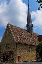 The church of Saint-Pierre, after restoration | |
 Lavaré Location within Pays de la Loire region  Lavaré | |
| Coordinates: 48°03′10″N 0°38′41″E / 48.0528°N 0.6447°ECoordinates: 48°03′10″N 0°38′41″E / 48.0528°N 0.6447°E | |
| Country | France |
| Region | Pays de la Loire |
| Department | Sarthe |
| Arrondissement | Mamers |
| Canton | Saint-Calais |
| Intercommunality | Communauté de communes du Val de Braye |
| Government | |
| • Mayor (2014–2020) | Nicolas Massé |
| Area1 | 22.88 km2 (8.83 sq mi) |
| Population (2011[1])2 | 848 |
| • Density | 37/km2 (96/sq mi) |
| Time zone | UTC+1 (CET) |
| • Summer (DST) | UTC+2 (CEST) |
| INSEE/Postal code | 72158 /72390 |
| Elevation | 86–199 m (282–653 ft) |
|
1 French Land Register data, which excludes lakes, ponds, glaciers > 1 km2 (0.386 sq mi or 247 acres) and river estuaries. 2 Population without double counting: residents of multiple communes (e.g., students and military personnel) only counted once. | |
Lavaré is a commune in the Sarthe department in the region of Pays-de-la-Loire in north-western France.
Twin towns – sister cities

See also
References
| Wikimedia Commons has media related to Lavaré. |
This article is issued from
Wikipedia.
The text is licensed under Creative Commons - Attribution - Sharealike.
Additional terms may apply for the media files.