Asnières-sur-Vègre
| Asnières-sur-Vègre | ||
|---|---|---|
| Commune | ||
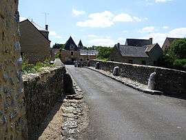 The old bridge | ||
| ||
 Asnières-sur-Vègre Location within Pays de la Loire region  Asnières-sur-Vègre | ||
| Coordinates: 47°53′22″N 0°13′59″W / 47.8894°N 0.2331°WCoordinates: 47°53′22″N 0°13′59″W / 47.8894°N 0.2331°W | ||
| Country | France | |
| Region | Pays de la Loire | |
| Department | Sarthe | |
| Arrondissement | La Flèche | |
| Canton | Sablé-sur-Sarthe | |
| Intercommunality | CC Sablé-sur-Sarthe | |
| Government | ||
| • Mayor (2014-2020) | Jean-Pierre Bourrely | |
| Area1 | 12.64 km2 (4.88 sq mi) | |
| Population (2015)2 | 400 | |
| • Density | 32/km2 (82/sq mi) | |
| Demonym(s) | Asniérois, Asniéroise | |
| Time zone | UTC+1 (CET) | |
| • Summer (DST) | UTC+2 (CEST) | |
| INSEE/Postal code | 72010 /72430 | |
| Elevation | 30–75 m (98–246 ft) | |
|
1 French Land Register data, which excludes lakes, ponds, glaciers > 1 km2 (0.386 sq mi or 247 acres) and river estuaries. 2 Population without double counting: residents of multiple communes (e.g., students and military personnel) only counted once. | ||
.svg.png)
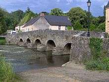
The bridge at Asnières
Asnières-sur-Vègre is a commune in the Sarthe department in the region of Pays-de-la-Loire in north-western France.
See also
References
| Wikimedia Commons has media related to Asnières-sur-Vègre. |
This article is issued from
Wikipedia.
The text is licensed under Creative Commons - Attribution - Sharealike.
Additional terms may apply for the media files.