Saint-Rémy-du-Val
| Saint-Rémy-du-Val | ||
|---|---|---|
| Commune | ||
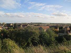 Saint-Rémy-du-Val seen from the ruins of the chateau | ||
| ||
 Saint-Rémy-du-Val Location within Pays de la Loire region  Saint-Rémy-du-Val | ||
| Coordinates: 48°20′59″N 0°15′17″E / 48.3497°N 0.2547°ECoordinates: 48°20′59″N 0°15′17″E / 48.3497°N 0.2547°E | ||
| Country | France | |
| Region | Pays de la Loire | |
| Department | Sarthe | |
| Arrondissement | Mamers | |
| Canton | Mamers | |
| Intercommunality | Saosnois | |
| Government | ||
| • Mayor (2008–2014) | Michel Brizard | |
| Area1 | 16.54 km2 (6.39 sq mi) | |
| Population (2006)2 | 577 | |
| • Density | 35/km2 (90/sq mi) | |
| Time zone | UTC+1 (CET) | |
| • Summer (DST) | UTC+2 (CEST) | |
| INSEE/Postal code | 72317 /72600 | |
| Elevation |
98–210 m (322–689 ft) (avg. 160 m or 520 ft) | |
|
1 French Land Register data, which excludes lakes, ponds, glaciers > 1 km2 (0.386 sq mi or 247 acres) and river estuaries. 2 Population without double counting: residents of multiple communes (e.g., students and military personnel) only counted once. | ||
.svg.png)
Saint-Rémy-du-Val is a commune in the Sarthe department in the region of Pays-de-la-Loire in north-western France.
See also
References
| Wikimedia Commons has media related to Saint-Rémy-du-Val. |
This article is issued from
Wikipedia.
The text is licensed under Creative Commons - Attribution - Sharealike.
Additional terms may apply for the media files.