Sablé-sur-Sarthe
| Sablé-sur-Sarthe | ||
|---|---|---|
| Commune | ||
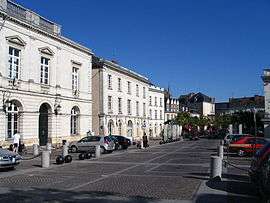 The town hall of Sablé in Raphaël Élizé square. | ||
| ||
 Sablé-sur-Sarthe Location within Pays de la Loire region  Sablé-sur-Sarthe | ||
| Coordinates: 47°51′02″N 0°19′45″W / 47.8505°N 0.3292°WCoordinates: 47°51′02″N 0°19′45″W / 47.8505°N 0.3292°W | ||
| Country | France | |
| Region | Pays de la Loire | |
| Department | Sarthe | |
| Arrondissement | La Flèche | |
| Canton | Sablé-sur-Sarthe | |
| Government | ||
| • Mayor (2008–2014) | Marc Joulaud | |
| Area1 | 36.92 km2 (14.25 sq mi) | |
| Population (2006)2 | 13,141 | |
| • Density | 360/km2 (920/sq mi) | |
| Time zone | UTC+1 (CET) | |
| • Summer (DST) | UTC+2 (CEST) | |
| INSEE/Postal code | 72264 /72300 | |
|
1 French Land Register data, which excludes lakes, ponds, glaciers > 1 km2 (0.386 sq mi or 247 acres) and river estuaries. 2 Population without double counting: residents of multiple communes (e.g., students and military personnel) only counted once. | ||
.svg.png)
Sablé-sur-Sarthe, commonly referred to as Sablé, is a commune in the Sarthe department, in the Pays de la Loire region, in western France. It is about 50 km northeast of Angers.
Geography
The Vaige forms part of the commune's north-western border, flows southwards through the middle of the commune, then flows into the Sarthe River in the town of Sablé-sur-Sarthe.
History
François Fillon was mayor of Sablé from 1983 to 2001.
Tourism
The town is a hub for river cruising along the Sarthe. There is a festival of baroque music every August.[1]
Industry
From 2010 to 2015, the motor car firm Venturi had a factory at Sablé-sur-Sarthe.[2][3][4]
Points of interest
See also
References
- ↑ FesTival de sablé, édition 2018 at lentracte-sable.fr, Accessed 28 April 2018
- ↑ Cédric Menuet, 19 March 2015: 'Sarthe: Venturi ferme son usine de Sablé-sur-Sarthe' (Sarthe: Venturi closes its Sablé-sur-Sarthe factory) at lejournaldesentreprises.com, Accessed 12 April 2018
- ↑ 'Venturi Eclectic, an electrical city-dweller' at drivehomesafe.com, Accessed 12 April 2018
- ↑ Kirby Garlitos, 25 June 2015 'Voxan Wattman electric motorcycle goes by the wayside', at topspeed.com, Accessed 12 April 2018
External links
| Wikimedia Commons has media related to Sablé-sur-Sarthe. |
- Town council website

This article is issued from
Wikipedia.
The text is licensed under Creative Commons - Attribution - Sharealike.
Additional terms may apply for the media files.