Bérus
| Bérus | ||
|---|---|---|
| Commune | ||
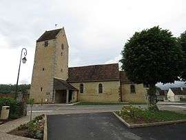 The church in Bérus | ||
| ||
 Bérus Location within Pays de la Loire region  Bérus | ||
| Coordinates: 48°22′27″N 0°03′03″E / 48.3742°N 0.0508°ECoordinates: 48°22′27″N 0°03′03″E / 48.3742°N 0.0508°E | ||
| Country | France | |
| Region | Pays de la Loire | |
| Department | Sarthe | |
| Arrondissement | Mamers | |
| Canton | Sillé-le-Guillaume | |
| Intercommunality | Communauté de communes des Portes du Maine Normand | |
| Government | ||
| • Mayor (2008–2014) | Gille Lamare | |
| Area1 | 6.73 km2 (2.60 sq mi) | |
| Population (2006)2 | 408 | |
| • Density | 61/km2 (160/sq mi) | |
| Demonym(s) | Bérusiens | |
| Time zone | UTC+1 (CET) | |
| • Summer (DST) | UTC+2 (CEST) | |
| INSEE/Postal code | 72034 /72610 | |
| Elevation | 141–196 m (463–643 ft) | |
|
1 French Land Register data, which excludes lakes, ponds, glaciers > 1 km2 (0.386 sq mi or 247 acres) and river estuaries. 2 Population without double counting: residents of multiple communes (e.g., students and military personnel) only counted once. | ||

Bérus is a commune in the Sarthe department in the region of Pays-de-la-Loire in north-western France.
See also
References
| Wikimedia Commons has media related to Bérus. |
This article is issued from
Wikipedia.
The text is licensed under Creative Commons - Attribution - Sharealike.
Additional terms may apply for the media files.