Beaumont-sur-Sarthe
| Beaumont-sur-Sarthe | ||
|---|---|---|
| Commune | ||
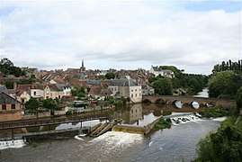 View of the town and river | ||
| ||
 Beaumont-sur-Sarthe Location within Pays de la Loire region  Beaumont-sur-Sarthe | ||
| Coordinates: 48°13′37″N 0°07′53″E / 48.2269°N 0.1314°ECoordinates: 48°13′37″N 0°07′53″E / 48.2269°N 0.1314°E | ||
| Country | France | |
| Region | Pays de la Loire | |
| Department | Sarthe | |
| Arrondissement | Mamers | |
| Canton | Sillé-le-Guillaume | |
| Intercommunality | CC Haute Sarthe Alpes Mancelles | |
| Government | ||
| • Mayor (2014–2020) | François Robin | |
| Area1 | 6.64 km2 (2.56 sq mi) | |
| Population (2014)2 | 1,945 | |
| • Density | 290/km2 (760/sq mi) | |
| Time zone | UTC+1 (CET) | |
| • Summer (DST) | UTC+2 (CEST) | |
| INSEE/Postal code | 72029 /72170 | |
|
1 French Land Register data, which excludes lakes, ponds, glaciers > 1 km2 (0.386 sq mi or 247 acres) and river estuaries. 2 Population without double counting: residents of multiple communes (e.g., students and military personnel) only counted once. | ||

Beaumont-sur-Sarthe (pre-revolutionary name: Beaumont-le-Vicomte) is a commune in the Sarthe department and Pays de la Loire region of north-western France.
The residents of Beaumont are known in French as les Belmontais.
Geography
As the name indicates, Beaumont lies on the River Sarthe. The town is situated midway between Alençon (23 km) and Le Mans (25 km). Ballon and Fresnay-sur-Sarthe are each 10 km away, Sillé-le-Guillaume is 20 km and Mamers 22 km away.
Twin towns
![]()
See also
References
| Wikimedia Commons has media related to Beaumont-sur-Sarthe. |
This article is issued from
Wikipedia.
The text is licensed under Creative Commons - Attribution - Sharealike.
Additional terms may apply for the media files.