Château-du-Loir
| Château-du-Loir | |
|---|---|
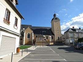 The church of Saint-Guingalois | |
 Château-du-Loir Location within Pays de la Loire region  Château-du-Loir | |
| Coordinates: 47°41′54″N 0°25′06″E / 47.6983°N 0.4183°ECoordinates: 47°41′54″N 0°25′06″E / 47.6983°N 0.4183°E | |
| Country | France |
| Region | Pays de la Loire |
| Department | Sarthe |
| Arrondissement | La Flèche |
| Canton | Château-du-Loir |
| Area1 | 11.46 km2 (4.42 sq mi) |
| Population (2014 [1])2 | 4,652 |
| • Density | 410/km2 (1,100/sq mi) |
| Time zone | UTC+1 (CET) |
| • Summer (DST) | UTC+2 (CEST) |
| INSEE/Postal code | 72071 /72500 |
| Elevation |
44–131 m (144–430 ft) (avg. 101 m or 331 ft) |
| Website | http://www.ville-chateauduloir.fr |
|
1 French Land Register data, which excludes lakes, ponds, glaciers > 1 km2 (0.386 sq mi or 247 acres) and river estuaries. 2 Population without double counting: residents of multiple communes (e.g., students and military personnel) only counted once. | |
Château-du-Loir is a former commune in the Sarthe department in the region of Pays de la Loire in north-western France. On 1 October 2016, it was merged into the new commune Montval-sur-Loir.[2]
Notable people
- Gervais II, lord of Château-du-Loir
- Cécile Didier (1888–1975), stage and film actress
- Guillaume des Roches (1165 - 1222), lord of Longué-Jumelles and Château-du-Loir, comrade in arms of Philippe Auguste
- Saint Siméon-François Berneux (1814 - 1866), one of the Korean Martyrs
- Pierre Loutrel (1916 - 1946), bandit
See also
References
- ↑ https://www.insee.fr/fr/statistiques/2534314?geo=COM-72071 Populations légales 2014 Commune de Château-du-Loir (72071)
- ↑ Arrêté préfectoral 28 June 2016 (in French)
| Wikivoyage has a travel guide for Château-du-Loir. |
| Wikimedia Commons has media related to Château-du-Loir. |
This article is issued from
Wikipedia.
The text is licensed under Creative Commons - Attribution - Sharealike.
Additional terms may apply for the media files.