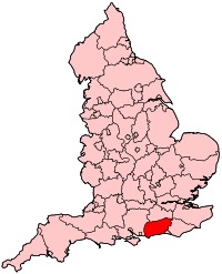
Mid Sussex
| Mid Sussex District | |
|---|---|
| Non-metropolitan district | |
 Boundary: Mid Sussex - Lewes | |
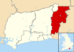 Mid Sussex shown within West Sussex | |
| Sovereign state | United Kingdom |
| Constituent country | England |
| Region | South East England |
| Non-metropolitan county | West Sussex |
| Status | Non-metropolitan district |
| Admin HQ | Haywards Heath |
| Incorporated | 1 April 1974 |
| Government | |
| • Type | Non-metropolitan district council |
| • Body | Mid Sussex District Council |
| • Leadership | Leader & Cabinet (Conservative) |
| • MPs |
Nick Herbert Jeremy Quin Nicholas Soames |
| Area | |
| • Total | 128.97 sq mi (334.02 km2) |
| Area rank | 130th (of 326) |
| Population (mid-2017 est.) | |
| • Total | 148,300 |
| • Rank | 135th (of 326) |
| • Density | 1,100/sq mi (440/km2) |
| • Ethnicity |
95.3% White 1.6% S.Asian 1.0% Black 1.2% Mixed Race |
| Time zone | UTC0 (GMT) |
| • Summer (DST) | UTC+1 (BST) |
| Website |
www |
Mid Sussex is a local government district in the English county of West Sussex. It contains the towns of East Grinstead, Haywards Heath and Burgess Hill.
The district was created on 1 April 1974 from parts of East Sussex: the urban districts of Cuckfield, Burgess Hill, and East Grinstead and nearly all of Cuckfield Rural, the far north-west of which was transferred to Crawley.
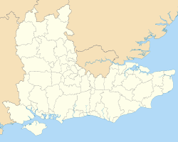
The district borders the Tandridge district of Surrey to the north, Wealden and Lewis districts to the east, and Brighton and Hove to the south, all in East Sussex, and Horsham district to the west and Crawley, northwest, equally in West Sussex.[1]
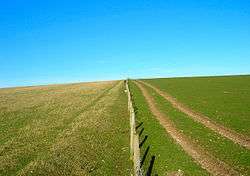
The Prime Meridian passes through the district, has most headwaters of the River Ouse, Sussex and its largest body of water is Ardingly reservoir which is used by watersports clubs. The north of the area is the High Weald and has sections of Ashdown Forest.
Civil parishes
Within the Mid Sussex District are the following civil parishes:[2]
| Parish | Type | Area (Hectare) | Population (2001) | Pop Density /Hectare |
|---|---|---|---|---|
| Albourne | Parish Council | 773 | 600 | 0.78 |
| Ardingly | Parish Council | 1609 | 1833 | 1.14 |
| Ashurst Wood | Parish Council | 251 | 1771 | 7.05 |
| Balcombe | Parish Council | 2105 | 1765 | 0.84 |
| Bolney | Parish Council | 1479 | 1209 | 0.82 |
| Burgess Hill | Town Council | 947 | 28803 | 30.42 |
| Cuckfield | Parish Council | 432 | 3266 | 7.57 |
| Cuckfield Rural | Parish Council | 3869 | 1574 | 0.41 |
| East Grinstead | Town Council | 2443 | 23942 | 9.80 |
| Fulking | Parish Council | 628 | 250 | 0.40 |
| Hassocks | Parish Council | 1088 | 6821 | 6.27 |
| Haywards Heath | Town Council | 975 | 22800 | 23.38 |
| Horsted Keynes | Parish Council | 1581 | 1507 | 0.95 |
| Hurstpierpoint and Sayers Common | Parish Council | 2030 | 6264 | 3.09 |
| Lindfield | Parish Council | 224 | 5394 | 24.07 |
| Lindfield Rural | Parish Council | 1981 | 2644 | 1.33 |
| Newtimber | Parish Council | 695 | 96 | 0.14 |
| Poynings | Parish Council | 666 | 287 | 0.43 |
| Pyecombe | Parish Council | 887 | 200 | 0.23 |
| Slaugham | Parish Council | 2432 | 2226 | 0.92 |
| Turners Hill | Parish Council | 1390 | 1849 | 1.33 |
| Twineham | Parish Council | 784 | 271 | 0.35 |
| West Hoathly | Parish Council | 2139 | 2121 | 0.99 |
| Worth | Parish Council | 1995 | 9888 | 4.96 |
| Mid Sussex | Total | 33403 | 127381 | 3.81 |
History
Population increased substantially in the 19th century, with most of this increase in the most urban areas and leading by its close to urban districts, town-based and rural districts, multi-village-based.
Mid Sussex was first, in 1885, another name for the Lewes constituency when Sussex representation was reformed to nine approximately equal electorate seats.
The first Parliamentary mention of a Mid Sussex body of any sort is in 1907, to the Mid Sussex Joint Water District, an amalgamation of private water companies to provide safe, treated, piped water.[3]
Sussex has been divided into East Sussex and West Sussex for taxation since the late medieval period but this divide changed for the first and most recent time in 1972. Changes were provided for under a 1972 Act, all major proposals debated in outline, and made in detail in its associated Order.
Mid Sussex's change in county was argued under the Redcliffe-Maud Report's Planning Area enhancing a Second Wilson ministry plan with support from locally resident Lords and of the Heath ministry. Under this plan West Sussex gained an irregular swathe of East Sussex as far as East Grinstead in the north and in its initially passed form, Crawley would have gained two parishes in Surrey instead of the Gatwick part of these — mostly reversed due to a local poll, before its 1974 implementation, with the Charlwood and Horley Act 1974. East to West Sussex land re-designation was kept with the stated aim of uniting all areas affected by the projected major Crawley and Gatwick Airport economy under one supervisory local authority.[4]
The decision was controversial but moved through the House of Lords from the despatch box by Lord Belstead, a well-respected Minister in the Lords:
I think it is fair to claim that this was why the South-East Strategic Plan referred to by ... Lord Nugent set up and defined five major growth areas. One of these, called Planning Area No. 6, extends in the area mentioned by the noble Lord from Horley and Charlwood in the North to the Southern boundaries of Horsham and Cuckfield or, taking it from the West, from Horsham Rural District and to Cuckfield, Burgess Hill and East Grinstead in the East. So this planning area spreads into three counties: Surrey, East Sussex and West Sussex.
But as has been said many times this evening, planning means people and it must not be remote from reality. I think for the good of the people living in this area—which has seen and will see such population growth—there are compelling arguments for the continued planning of the area to be conducted by one authority. It is a fact that whenever this area running from Horley through Gatwick down to Crawley has been studied the conclusion has been reached—and this has been mentioned by my noble friend Viscount Mersey and by Lord Lytton—that this Gatwick area within the Planning Area should be looked at as one entity. The need to put Horley, Gatwick and Crawley together was recognised by Redcliffe-Maud, and although the Commission carved off East Surrey from West Surrey-and put Gatwick in the East, as the noble Lord, Lord Garnsworthy, has reminded us, I think it is an answer to...Lord Hanworth, and to my noble friend Lord Reigate, that surely nobody from Surrey would now ask for that to be done to their county. In any event, that solution was overtaken by the South-East Strategic Plan. I must confess that the expression, "Strategic Plan." has a cold and impersonal ring.
...The three county councils of Surrey, East Sussex, and West Sussex have been consulting on a joint advisory committee for this area.[5]
Home ownership
Homes owned by their occupants, with or without a loan, make up more than 85% of Mid Sussex housing. Mid Sussex's residents had the lowest burden of social housing, at 0.5% of housing stock, at the time of the census, a district which is approximately 30 minutes by its fast railway services from the area with the highest such proportion covering London Bridge station, the London Borough of Southwark (having 31.2% social housing) and from a creative and self-declared, progressive authority with 9.8% social housing and 28% of its housing privately rented, Brighton and Hove.
In terms of rented housing Mid Sussex at the 2011 census ranked 216th out of in terms of 327 local authorities in England. The proportion of homes which were rented as investments by non-occupants was higher than several other semi-rural districts of Sussex, with 11.7% of housing stock speculatively acquired in this way or to provide for those unable to obtain mortgage finance and 1.0% was let out to residents on either public or private shared ownership schemes, close to the national average. These figures are those of the 2011 census.[6]
Local politics
The parliamentary constituency of Mid Sussex covers most (but not all) of the district, and is held by the Conservative Party. The incumbent Member of Parliament (MP) is Sir Nicholas Soames,[7] the grandson of former Prime Minister Sir Winston Churchill, and a former junior minister in the Government of Sir John Major (1990–97). The southernmost part of the district, including Hassocks and Hurstpierpoint falls within Arundel and South Downs whose MP is Nick Herbert.[8]
See also
References
- ↑ Mid Sussex District - location map Archived 11 October 2007 at the Wayback Machine. Mid Sussex District Council. Retrieved 2015-01-30
- ↑ "2001 Census: West Sussex – Population by Parish" (PDF). West Sussex County Council. Archived from the original (PDF) on 8 June 2011. Retrieved 26 March 2009.
- ↑ "LOCAL GOVERNMENT PROVISIONAL ORDERS (No. 11) BILL". Parliamentary Debates (Hansard). House of Commons. May 14, 1907. col. 765–765.
- ↑ The English Non-metropolitan Districts (Definition) Order 1972: Schedule: Part 38
- ↑ "LOCAL GOVERNMENT BILL". Parliamentary Debates (Hansard). House of Lords. September 11, 1972. col. 157–159.
- ↑ Office for National Statistics 2011 Census Key Statistics: Tenure.
- ↑ Rt Hon Nicholas Soames - UK Parliament
- ↑ Rt Hon Nick Herbert - UK Parliament
Coordinates: 51°1′14.4″N 0°8′14.38″W / 51.020667°N 0.1373278°W