Adur District
| Adur District | |
|---|---|
| Non-metropolitan district | |
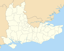
 Adur shown within West Sussex | |
| Sovereign state | United Kingdom |
| Constituent country | England |
| Region | South East England |
| Non-metropolitan county | West Sussex |
| Status | Non-metropolitan district |
| Admin HQ | Shoreham-by-Sea |
| Incorporated | 1 April 1974 |
| Government | |
| • Type | Non-metropolitan district council |
| • Body | Adur District Council |
| • Leadership | Alternative - Sec. 31 (Conservative) |
| • MPs | Tim Loughton |
| Area | |
| • Total | 16.14 sq mi (41.80 km2) |
| Area rank | 285th (of 326) |
| Population (mid-2017 est.) | |
| • Total | 63,700 |
| • Rank | 312th (of 326) |
| • Density | 3,900/sq mi (1,500/km2) |
| • Ethnicity |
95.9% White 1.3% S.Asian 1.2% Mixed |
| Time zone | UTC0 (GMT) |
| • Summer (DST) | UTC+1 (BST) |
| ONS code | 45UB (ONS) E07000223 (GSS) |
| OS grid reference | TQ220051 |
| Website | Adur & Worthing councils |
Adur (/eɪˈdʊər/) is a local government district of West Sussex, England. It is named after its main river and is historically part of the English county of Sussex. The council is based in Shoreham-by-Sea and the district has a population of 59,627 according to the 2001 census.
It was created on 1 April 1974 by the merger of Southwick and Shoreham urban districts and the civil parishes of Coombes, Lancing and Sompting from Worthing Rural District.
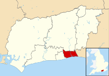
Sompting, Lancing, Shoreham-by-Sea (or Shoreham) and Southwick form a strip of settlements on the south coast, between Worthing and Brighton and Hove collectively known as the Brighton/Worthing/Littlehampton conurbation. Coombes is inland. Fishersgate and Kingston by Sea (also known as Kingston Buci) are also small areas in the south east of the district.
Shoreham Airport is located in the Adur district, west of Shoreham-by-Sea and just east of Lancing.
The Adur festival is held in the first two weeks of June every year.
Politics
Elections to the district council have been held every 2 years since the 2004 election, when the council changed to being elected by halves instead of by thirds. The Conservative party has had a majority on the council since the 2002 election. Following the 2016 election the council is composed of the following:
| Party | Councillors | |
| Conservative Party | 16 | |
| UKIP | 6 | |
| Labour Party | 4 | |
| Independent | 3 | |
Sports clubs
Twin towns
Adur is twinned with
Climate
Climate in this area has mild differences between highs and lows, and there is adequate rainfall year-round. The Köppen Climate Classification subtype for this climate is "Cfb" (Marine West Coast Climate/Oceanic climate).[4]
| Climate data for Adur District, UK | |||||||||||||
|---|---|---|---|---|---|---|---|---|---|---|---|---|---|
| Month | Jan | Feb | Mar | Apr | May | Jun | Jul | Aug | Sep | Oct | Nov | Dec | Year |
| Average high °C (°F) | 8 (46) |
8 (46) |
10 (50) |
13 (55) |
16 (61) |
18 (64) |
20 (68) |
21 (70) |
19 (66) |
15 (59) |
11 (52) |
8 (46) |
14 (57) |
| Average low °C (°F) | 3 (37) |
3 (37) |
5 (41) |
6 (43) |
10 (50) |
12 (54) |
14 (57) |
14 (57) |
12 (54) |
9 (48) |
6 (43) |
4 (39) |
8 (46) |
| Average precipitation mm (inches) | 43 (1.7) |
30 (1.2) |
30 (1.2) |
28 (1.1) |
36 (1.4) |
18 (0.7) |
36 (1.4) |
36 (1.4) |
38 (1.5) |
50 (2) |
50 (2) |
48 (1.9) |
442 (17.4) |
| Average precipitation days | 14 | 10 | 12 | 12 | 10 | 9 | 10 | 10 | 11 | 12 | 13 | 12 | 135 |
| Source: Weatherbase [5] | |||||||||||||
See also
References
- ↑ "Internetowy Serwis Miejski". zywiec.pl. 2008-06-20. Archived from the original on 2011-05-14. Retrieved 2011-06-03.
- ↑ "National Commission for Decentralised cooperation". Délégation pour l’Action Extérieure des Collectivités Territoriales (Ministère des Affaires étrangères) (in French). Archived from the original on 2013-10-04. Retrieved 2013-12-26.
- ↑ "British towns twinned with French towns". Archant Community Media Ltd. Retrieved 2013-07-11.
- ↑ Climate Summary for Adur, UK
- ↑ "Weatherbase.com". Weatherbase. 2013. Archived from the original on 2013-07-10. Retrieved on July 9, 2013.