Metropolitan Borough of Wirral
| Wirral | ||
|---|---|---|
| Metropolitan borough | ||
 Wallasey Town Hall | ||
| ||
 Wirral shown within Merseyside | ||
| Sovereign state |
| |
| Constituent country |
| |
| Region | North West England | |
| City region | Liverpool | |
| Ceremonial county | Merseyside | |
| Established | 1 April 1974 | |
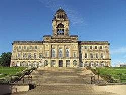
| Administrative HQ | Wallasey (Town Hall) | |
| Government | ||
| • Type | Metropolitan Borough | |
| • Body | Wirral Council | |
| • Leadership | Leader and cabinet | |
| • Executive | Labour | |
| • Leader | Phil Davies | |
| • Civic Mayor | Geoffrey Watt | |
| • Deputy Civic Mayor | Tony Smith | |
| Area | ||
| • Total | 60.6 sq mi (157.0 km2) | |
| Area rank | 185th | |
| Population (mid-2017 est.) | ||
| • Total | 322,800 | |
| • Rank | Ranked 30th | |
| • Density | 5,320/sq mi (2,055/km2) | |
| • Ethnicity | 98.3% white | |
| Demonym(s) | Wirralian | |
| Time zone | UTC+0 (Greenwich Mean Time) | |
| • Summer (DST) | UTC+1 (British Summer Time) | |
| Postcode area | CH | |
| Dialling code | 0151 | |
| ISO 3166 code | GB-WRL | |
| GSS code | E08000015 | |
| NUTS 3 code | UKD74 | |
| ONS code | 00CB | |
| Website | www.wirral.gov.uk | |
The Metropolitan Borough of Wirral is a metropolitan borough of Merseyside, in North West England. It has a population of 321,238,[1] and encompasses 60 square miles (160 km2) of the northern part of the Wirral Peninsula. Major settlements include Birkenhead, Wallasey, Bebington, Heswall, Hoylake and West Kirby. The city of Liverpool over the Mersey, faces the northeastern side of Wirral. Bordering is the River Mersey to the east, the Irish Sea to the north and the River Dee to the west; the borough of Cheshire West and Chester occupies the remainder of the Wirral Peninsula and borders the borough of Wirral to the south. The borough of Wirral has greater proportions of rural areas than the Liverpool part of Merseyside.
History
The borough was formed on 1 April 1974, under the Local Government Act 1972, as a merger of the county boroughs of Birkenhead and Wallasey, along with the municipal borough of Bebington and the urban districts of Hoylake and Wirral.
Economy
This is a chart of trend of regional gross value added of Wirral at current basic prices published (pp. 240–253) by Office for National Statistics with figures in millions of British Pounds Sterling.
| Year | Regional Gross Value Added | Agriculture | Industry | Services |
|---|---|---|---|---|
| 1995 | 2,089 | 10 | 674 | 1,405 |
| 2000 | 2,609 | 5 | 814 | 1,789 |
| 2003 | 3,020 | 9 | 755 | 2,256 |
^ includes hunting and forestry
^ includes energy and construction
^ includes financial intermediation services indirectly measured
^ Components may not sum to totals due to rounding
In September 2006 a large scale development called Wirral Waters was unveiled by the company Peel Holdings, that if constructed as outlined may see the creation of up to 27,000 jobs.
Education
When the borough was set up in 1974, it inherited comprehensive systems from the former County Boroughs of Birkenhead and Wallasey. In the part of Wirral formerly administered by Cheshire County Council, it inherited a selective system of grammar and secondary modern non-Roman Catholic schools and a comprehensive Roman Catholic school (St John Plessington Catholic College).
Until the implementation of the Education Reform Act 1988, education in Wirral continued to be organised in four areas; Birkenhead, Wallasey and the former parts of Cheshire known for education purposes as "Bebington" and "Deeside". However this Act introduced "open enrolment", allowing parents from anywhere in the borough, and outside it, to apply for a place for their child at any secondary school. As a result, significant numbers of pupils from the former "comprehensive areas" attend schools in the former "selective areas" and vice versa. The distinction between different types of school was to an extent masked, as all secondary modern and most comprehensive schools were named "High School". As a further result of this Act, St Anselm's College and Upton Hall School, both within the Birkenhead education area, became the only independent schools in the country to become state funded grant-maintained schools, retaining selective admissions policies to become Roman Catholic grammar schools.
A further change came as a result of the School Standards and Framework Act 1998, which effectively changed secondary modern schools into comprehensives as schools were no longer permitted to select by examination failure. In summary, Wirral now has a state secondary sector made up of 16 comprehensive schools (of which two are Roman Catholic) and 6 grammar schools (of which two are Roman Catholic).
Local government
Liverpool City Region Combined Authority
The Metropolitan Borough of Wirral is one of the six constituent local government districts of the Liverpool City Region. Since 1 April 2014, some of the borough's responsibilities have been pooled with neighbouring authorities within the metropolitan area and subsumed into the Liverpool City Region Combined Authority.
The combined authority has effectively become the top-tier administrative body for the local governance of the city region and the leader of Wirral Borough Council, along with the five other leaders from neighbouring local government districts, take strategic decisions over economic development, transport, employment and skills, tourism, culture, housing and physical infrastructure.
As of July 2015, negotiations are currently taking place between the UK national government and the combined authority over a possible devolution deal to confer greater powers on the region. Discussions include whether to introduce an elected ‘Metro Mayor’ to oversee the entire metropolitan area.[2]
Wirral Borough Council Composition
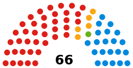
After the local elections in 2008 the Metropolitan Borough of Wirral was governed by a Labour Party/Liberal Democrat coalition, the second and third largest parties on the council respectively. Cllr Steve Foulkes of Labour was Leader of the Council. The Conservative Party was the largest party represented, and was in opposition with its leader Cllr Jeff Green being leader of the opposition.
After the local elections in 2010 the Metropolitan Borough of Wirral was governed by a Conservative Party/Liberal Democrat coalition, which reflected the coalition at national level.[3] The Conservative Party, continuing to be the largest party represented on the council increased its number of seats by 2 to 27 and has now entered into coalition government with the Liberal Democrats as the leading coalition partner with the leader of the Conservatives, Cllr Jeff Green, becoming the new leader of the council. The Labour Party increased its representation on the council by 4 to 24 and remained the second largest party though they are now in opposition with their leader, Cllr Steve Foulkes, who was leader of the council now leader of the opposition. The Liberal Democrats lost 4 seats decreasing their tally to 15 remaining the third largest party on the council but continuing to participate in the governing of the council as the junior coalition partner to the Conservatives. The one independent represented on the council lost their seat.
After the local elections in 2011 the Metropolitan Borough of Wirral was governed by a minority Labour Party administration. Cllr Steve Foulkes was leader of the Council with Cllr Phil Davies as deputy leader. The Liberal Democrats lost a councillor who switched to Labour, Cllr Steve Niblock shortly after the elections. There are now no independents on Wirral Council. Labour have 36 seats, Conservatives have 23 and the Liberal Democrats 7.
In February 2012 the Conservatives and Liberal Democrats defeated the Labour administration in a motion of no confidence and the two parties governed again until the May election.[4] Labour made gains in May 2012, gaining majority control of the council for the first time since local elections in 2002 saw Labour become a minority. Wirral is led by Phil Davies.
In 2014, The Green Party gained their first seat on the council, defeating Labour in their typically safe seat of Birkenhead and Tranmere. They retained it in 2018 with an increased vote share, albeit with a reduced majority.
| Year | Party | Ref | |||||||||
|---|---|---|---|---|---|---|---|---|---|---|---|
| Conservative | Green | Labour | SDP–Liberal | Other | |||||||
| Lib Dem | |||||||||||
| 1973 | 29 | 0 | 24 | 13 | 0 | [5] | |||||
| 1974 | |||||||||||
| 1975 | 35 | 0 | 21 | 9 | 0 | ||||||
| 1976 | 42 | 0 | 18 | 6 | 0 | ||||||
| 1977 | |||||||||||
| 1978 | 45 | 0 | 16 | 5 | 0 | ||||||
| 1978 | 40 | 0 | 20 | 6 | 0 | ||||||
| 1980 | 37 | 0 | 23 | 6 | 0 | ||||||
| 1981 | |||||||||||
| 1982 | 35 | 0 | 25 | 6 | 0 | ||||||
| 1983 | 34 | 0 | 24 | 8 | 0 | ||||||
| 1984 | |||||||||||
| 1985 | |||||||||||
| 1986 | 30 | 0 | 26 | 10 | 0 | ||||||
| 1987 | 29 | 0 | 27 | 10 | 0 | ||||||
| 1988 | 22 | 0 | 34 | 10 | 0 | ||||||
| 1989 | |||||||||||
| 1990 | 23 | 0 | 33 | 7 | 3 | ||||||
| 1991 | 24 | 0 | 34 | 7 | 1 | ||||||
| 1992 | 29 | 0 | 31 | 6 | 0 | ||||||
| 1993 | |||||||||||
| 1994 | 28 | 0 | 30 | 8 | 0 | ||||||
| 1995 | 22 | 0 | 36 | 8 | 0 | ||||||
| 1996 | 16 | 0 | 41 | 9 | 0 | ||||||
| 1997 | |||||||||||
| 1998 | 16 | 0 | 41 | 8 | 1 | ||||||
| 1999 | 17 | 0 | 39 | 10 | 0 | ||||||
| 2000 | 20 | 0 | 34 | 12 | 0 | ||||||
| 2001 | |||||||||||
| 2002 | 20 | 0 | 32 | 12 | 2 | [6] | |||||
| 20 | 0 | 31 | 14 | 1 | |||||||
| 2003 | 23 | 0 | 26 | 16 | 1 | [7] | |||||
| 2004 | 21 | 0 | 26 | 19 | 0 | [8] | |||||
| 20 | 0 | 26 | 19 | 1 | [9] | ||||||
| 2005 | 21 | 0 | 26 | 18 | 1 | [10] | |||||
| 2006 | 21 | 0 | 26 | 19 | 0 | [11] | |||||
| 2007 | 21 | 0 | 25 | 20 | 0 | [12] | |||||
| 20 | 0 | 25 | 20 | 1 | [13] | ||||||
| 2008 | 20 | 0 | 25 | 19 | 2 | [14] | |||||
| 24 | 0 | 21 | 20 | 1 | |||||||
| 2009 | 25 | 0 | 20 | 20 | 1 | [15] | |||||
| 2010 | 27 | 0 | 24 | 15 | 0 | [16] | |||||
| 2011 | 27 | 0 | 29 | 10 | 0 | [17] | |||||
| 27 | 0 | 30 | 9 | 0 | [18] | ||||||
| 2012 | 22 | 0 | 37 | 7 | 0 | [19] | |||||
| 2013 | 23 | 0 | 36 | 7 | 0 | [20] | |||||
| 22 | 0 | 37 | 7 | 0 | [21] | ||||||
| 22 | 0 | 37 | 6 | 1 | [22] | ||||||
| 2014 | 21 | 1 | 38 | 6 | 0 | [23] | |||||
| 2015 | 21 | 1 | 39 | 5 | 0 | [24] | |||||
| 2016 | 21 | 1 | 38 | 5 | 1 | [25] | |||||
| 21 | 1 | 39 | 5 | 0 | [26] | ||||||
| 2017 | [27] | ||||||||||
| 2018 | [28] | ||||||||||
Members of Parliament
Places of interest
Wirral Council maintains five designated Local Nature Reserves: Bidston Moss, Dibbinsdale, Heswall Dales, Hilbre Island and Thurstaston Common.[29] It also operates the Merseyside part of Wirral Country Park, which was the first country park to be established in Britain.[30]
International relations
Twin towns — sister cities
The Metropolitan Borough of Wirral is twinned or has sister city relationships with:
See also
- Wirral Waterfront SRB — a regeneration initiative
References
- ↑ "Wirral population estimate (mid 2016)". Office for National Statistics. Retrieved 12 September 2017.
- ↑ Liam Murphy (22 July 2015). "Liverpool city region to decide on devolution demands by end of summer". Retrieved 26 July 2015.
- ↑ Phibbs, Harry (25 May 2010). "Conservatives take over Wirral Council". Conservativehome.blogs.com. Retrieved 11 December 2010.
- ↑ Murphy, Liam (14 February 2012). "Jeff Green is new leader of Wirral council after Labour group is kicked out". Liverpool Daily Post. Archived from the original on 17 February 2012. Retrieved 29 February 2012.
- ↑ "Council compositions". The Elections Centre. Retrieved 27 July 2018.
- ↑ "Local Election - 02 May 2002". Wirral Metropolitan Borough Council. Retrieved 27 July 2018.
- ↑ "Local Election - 01 May 2003". Wirral Metropolitan Borough Council. Retrieved 27 July 2018.
- ↑ "Local Election - 10 June 2004". Wirral Metropolitan Borough Council. Retrieved 27 July 2018.
- ↑ "'No respect for mayor'". Wirral Globe.
- ↑ "Why I jumped ship to join the Tories". Wirral Globe.
- ↑ "Local Election - 4 May 2006". Wirral Metropolitan Borough Council. Retrieved 27 July 2018.
- ↑ "Local Election - 03 May 2007". Wirral Metropolitan Borough Council. Retrieved 27 July 2018.
- ↑ "Another one bites the dust". Wirral Globe.
- ↑ "Election Result for 1 May 2008 2002". Wirral Metropolitan Borough Council. Retrieved 27 July 2018.
- ↑ "BREAKING NEWS: Labour councillor Denis Knowles quits and joins Tories at Wallasey Town Hall". Wirral Globe.
- ↑ "Election Result for 6 May 2010". Wirral Metropolitan Borough Council. Retrieved 27 July 2018.
- ↑ "Election Result for 5 May 2011". Wirral Metropolitan Borough Council. Retrieved 27 July 2018.
- ↑ "Wirral Lib Dem Steve Niblock defects to Labour Party". BBC News.
- ↑ "Election Result for 3 May 2012". Wirral Metropolitan Borough Council. Retrieved 27 July 2018.
- ↑ "Conservative victory in Wirral by-elections". Wirral Globe.
- ↑ "UPDATED: Labour victory in Wirral Council by-election". Wirral Globe.
- ↑ "Wirral councillor Mark Johnson quits Liberal Democrat Party". Liverpool Echo.
- ↑ "Election Result for 22 May 2014". Wirral Metropolitan Borough Council. Retrieved 27 July 2018.
- ↑ "Election Result for 7 May 2015". Wirral Metropolitan Borough Council. Retrieved 27 July 2018.
- ↑ "Seven things to talk about after the Wirral local elections 2015". Liverpool Echo. Retrieved 27 July 2018.
- ↑ "Councillors". Wirral Metropolitan Borough Council. Retrieved 27 July 2018.
- ↑ "Labour keeps control of Claughton in by-election". Wirral Globe.
- ↑ "Wirral Metropolitan Borough Council Election 2018 Results". BBC News.
- ↑ "Wirral Local Nature Reserves". Wirral council. Retrieved 28 January 2011.
- ↑ "Wirral Country Park". Wirral.gov.uk. Retrieved 11 November 2017.
- ↑ "Miasta partnerskie i zaprzyjaźnione Nowego Sącza" ["The twin cities and friendly Nowy Sącz"]. Urząd Miasta Nowego Sącza (in Polish). Archived from the original on 23 May 2013. Retrieved 1 August 2013.
- 1 2 "British towns twinned with French towns". Archant Community Media Ltd. Archived from the original on 5 July 2013. Retrieved 20 July 2013.
External links
| Wikimedia Commons has media related to Metropolitan Borough of Wirral. |
Neighbouring ceremonial/preserved counties and principal areas | ||||||||||
|---|---|---|---|---|---|---|---|---|---|---|
| ||||||||||
Coordinates: 53°23′49″N 3°00′43″W / 53.396972°N 3.011914°W