Allerdale
Coordinates: 54°38′24″N 3°24′43″W / 54.640°N 3.412°W
| Borough of Allerdale | ||
|---|---|---|
| Borough | ||
| ||
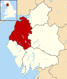 Shown within Cumbria | ||
| Sovereign state | United Kingdom | |
| Constituent country | England | |
| Region | North West England | |
| Ceremonial county | Cumbria | |
| Historic county | Cumberland | |
| Admin. HQ | Workington | |
| Government | ||
| • Type | Allerdale Borough Council | |
| • Leadership: | Leader & Cabinet | |
| • Executive: | Labour / Independent | |
| • MPs: | Sue Hayman, Rory Stewart | |
| Area | ||
| • Total | 480 sq mi (1,242 km2) | |
| Area rank | 17th | |
| Population (mid-2017 est.) | ||
| • Total | 97,200 | |
| • Rank | Ranked 250th | |
| • Density | 200/sq mi (78/km2) | |
| Time zone | UTC+0 (Greenwich Mean Time) | |
| • Summer (DST) | UTC+1 (British Summer Time) | |
| ONS code | 16UB (ONS) E07000026 (GSS) | |
| Ethnicity | 99.4% White | |
| Website | allerdale.gov.uk | |
Allerdale is a non-metropolitan district of Cumbria, England, with borough status. Its council is based in Workington and the borough has a population of 93,492 according to the 2001 census, increasing to 96,422 at the 2011 Census.[1]
The Borough of Allerdale was formed under the Local Government Act 1972, on 1 April 1974 by the merger of the municipal borough of Workington, the urban districts of Maryport, Cockermouth and Keswick; and the rural districts of Cockermouth and Wigton, all of which were within the administrative county of Cumberland. In 1995 Allerdale was granted borough status.
The name derives from the ancient region of Allerdale, represented latterly by the two wards of Cumberland, called Allerdale above Derwent and Allerdale below Derwent the present borough corresponding largely to the latter with parts of the former. Much of the area during the medieval period was a Royal Forest subject to forest law.[2]
Politics
Elections to the borough council are held every four years with 56 councillors being elected from 31 wards. No party has had a majority on the council since Labour lost their majority at the 2003 election. As of the 2011 election, and following a number of by-elections and defections, the council is composed of the following councillors:[3][4][5]
| Date | Labour | +/- | Conservative | +/- | Independent | +/- | Liberal Democrat | +/- | UKIP | +/- | Control | |||||
| 2011 | 28 | 12 | 15 | 1 | 0 | NOC | ||||||||||
| 2013 | 27 | -1 | 12 | = | 16 | +1 | 0 | -1 | 1 | +1 | NOC | |||||
| 2014 | 27 | = | 12 | = | 13 | -3 | - | 4 | +3 | NOC | ||||||
| 2015 | 28 | +1 | 17 | +5 | 8 | -5 | - | 3 | -1 | NOC | ||||||
| Dec 2016[6][7][8] | 28 | = | 16 | -1 | 10 | +2 | - | 2 | -1 | NOC | ||||||
References
- ↑ "Local Authority population 2011". Retrieved 16 June 2015.
- ↑ Raymond Grant (1991). The royal forests of England. Wolfeboro Falls, NH: Alan Sutton. ISBN 0-86299-781-X. 086299781X. See table, p221
- ↑ "England council elections". BBC News. Archived from the original on 19 May 2011. Retrieved 15 May 2011.
- ↑ "Councillors by Party". Allerdale Borough Council. Retrieved 19 May 2014.
- ↑ "Allerdale Councillors Join UKIP". News and Star. Retrieved 20 May 2014.
- ↑ Democratic Services, democratic services@allerdale gov uk (23 March 2018). "Allerdale Borough Council – Your Councillors". Government of the United Kingdom. Retrieved 23 March 2018.
- ↑ http://www.timesandstar.co.uk/news/other/-New-councillors-elected--16cbcc48-fdcd-47cb-bd5f-d1c4886baf15-ds
- ↑ democratic.services@allerdale.gov.uk, Democratic Services,. "Political makeup – Allerdale Borough Council". Government of the United Kingdom. Retrieved 23 March 2018.
Cumbria Portal | |
| Boroughs or districts | |
| Major settlements |
|
| Topics | |