Sandwell
| Borough of Sandwell | ||
|---|---|---|
| Metropolitan borough | ||
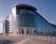
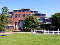 Sandwell Council House in Oldbury, West Midlands | ||
| ||
| Motto(s): Unity and Progress | ||
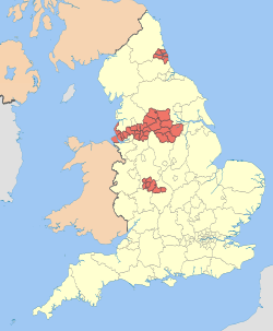
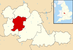 Sandwell shown within the West Midlands and England | ||
| Coordinates: 52°30′19″N 2°1′2″W / 52.50528°N 2.01722°WCoordinates: 52°30′19″N 2°1′2″W / 52.50528°N 2.01722°W | ||
| Sovereign state | United Kingdom | |
| Constituent country | England | |
| Region | West Midlands | |
| Metropolitan county | West Midlands | |
| Historic County | Staffordshire and Worcestershire | |
| Status | Metropolitan borough | |
| Incorporated | 1 April 1974 | |
| Admin HQ | Oldbury | |
| Government | ||
| • Type | Metropolitan district council | |
| • Body | Sandwell Metropolitan Borough Council | |
| • Leadership | Leader & Cabinet (Labour) | |
| • Mayor | Cllr. Barbara Price[1] | |
| • MPs |
Rt. Hon. John Spellar (L) Adrian Bailey (L) Tom Watson (L) James Morris (C) | |
| Area | ||
| • Total | 33 sq mi (86 km2) | |
| Population (mid-2017 est.) | ||
| • Total | 325,500 (Ranked 26th) | |
| • Density | 9,720/sq mi (3,752/km2) | |
| • Ethnicity |
69.9% White 19.2% Asian 5.9% Black 3.3% Mixed Race 0.3% Arab 1.3% Other[2] | |
| Time zone | UTC0 (GMT) | |
| • Summer (DST) | UTC+1 (BST) | |
| Postcode | B, DY, WS | |
| Area code(s) | 0121, 01384 | |
| ISO 3166 code | GB-SAW | |
| ONS code |
00CS (ONS) E08000028 (GSS) | |
| OS grid reference | SO9954890217 | |
| NUTS 3 | UKG37 | |
| Website |
www | |

Sandwell is a metropolitan borough of the West Midlands county in England. The borough is named after the Sandwell Priory, and spans a densely populated part of the West Midlands conurbation. According to Sandwell Metropolitan Borough Council, the borough comprises the six towns of Oldbury, Rowley Regis, Smethwick, Tipton, Wednesbury, and West Bromwich,[3] although these places consist of numerous smaller settlements and localities. Though West Bromwich is the largest town in the borough and its designated Strategic Town Centre, Sandwell Council House (the headquarters of the local authority) is situated in Oldbury.
Bordering Sandwell is the City of Birmingham to the east, the Metropolitan Borough of Dudley to the south and west, the Metropolitan Borough of Walsall to the north, and the City of Wolverhampton to the north-west. Spanning the borough are the parliamentary constituencies of West Bromwich West, West Bromwich East, Warley, and part of Halesowen and Rowley Regis, which crosses into the Dudley borough.
At the 2011 census, the borough had population of 309,000 and an area of 86 square kilometres (33 sq mi).[4]
History and Culture
The Metropolitan Borough of Sandwell was formed on 1 April 1974 as an amalgamation of the county boroughs of Warley (ceremonially within Worcestershire) and West Bromwich (ceremonially within Staffordshire), under the Local Government Act 1972. Warley had been formed in 1966 by a merger of the county borough of Smethwick with the municipal boroughs of Rowley Regis and Oldbury;[5] at the same time, West Bromwich had absorbed the boroughs of Tipton and Wednesbury.[6]
For its first 12 years of existence, Sandwell had a two-tier system of local government; Sandwell Council shared power with the West Midlands County Council. In 1986 the county council was abolished, and Sandwell effectively became a unitary authority. The borough is divided into 24 Wards and is represented by 72 ward councillors on the borough council.
The borough was named after Sandwell Priory, the ruins of which are located in Sandwell Valley. The local council has considered changing its name in the past over confusion outside the West Midlands as to the whereabouts of the borough, and in June 2002 a survey of borough residents was carried out. Sixty-five percent of those surveyed favoured retaining the name Sandwell.[7]
Landmarks and attractions in Sandwell include Wednesbury Museum and Art Gallery, Bishop Asbury Cottage, West Bromwich Manor House, Oak House, West Bromwich, Sandwell Valley Country Park, and The Public. It is also the home of West Bromwich Albion F.C..
Politics
Most of Sandwell Metropolitan Borough Council's councillors are members of the Labour Party.[8] Since the council election in 2016, the political composition of the council has been as follows:[9]
| Party | Councillors | |
| Labour Party | 70 | |
| UKIP | 2 | |
| Independent | 1 | |
From the borough's creation in 1974, all Members of Parliament (MPs) within its boundaries were Labour, but in the 2010 general election, Conservative party candidate James Morris was elected to the Halesowen and Rowley Regis seat which incorporates the Sandwell communities of Rowley Regis, Blackheath and Cradley Heath, and the neighbouring area of Halesowen which is situated within Dudley's borders. This is the very first time Sandwell has had a Tory MP - or indeed an MP from any party other than Labour.[10]
Wards
The Sandwell Borough is divided into 24 electoral wards, with each one represented by 3 councillors on the borough council:[9]
| Ward name | Area | Population (2011 census) | Population density (people per hectare) | Ref. |
|---|---|---|---|---|
| Abbey | 211 hectares (0.81 sq mi) | 11,752 | 55.6 | [11] |
| Blackheath | 260 hectares (1.0 sq mi) | 12,292 | 47.3 | [12] |
| Bristnall | 231 hectares (0.89 sq mi) | 12,151 | 52.5 | [13] |
| Charlemont with Grove Vale | 522 hectares (2.02 sq mi) | 11,964 | 22.9 | [14] |
| Cradley Heath and Old Hill | 403 hectares (1.56 sq mi) | 13,365 | 33.6 | [15] |
| Friar Park | 299 hectares (1.15 sq mi) | 12,625 | 42.3 | [16] |
| Great Barr with Yew Tree | 346 hectares (1.34 sq mi) | 12,597 | 36.4 | [17] |
| Great Bridge | 325 hectares (1.25 sq mi) | 12,962 | 39.9 | [18] |
| Greets Green and Lyng | 412 hectares (1.59 sq mi) | 11,769 | 28.6 | [19] |
| Hateley Heath | 309 hectares (1.19 sq mi) | 14,227 | 46.1 | [20] |
| Langley | 290 hectares (1.1 sq mi) | 12,969 | 44.8 | [21] |
| Newton | 276 hectares (1.07 sq mi) | 11,558 | 41.8 | [22] |
| Oldbury | 621 hectares (2.40 sq mi) | 13,606 | 21.9 | [23] |
| Old Warley | 267 hectares (1.03 sq mi) | 11,915 | 44.6 | [24] |
| Princes End | 278 hectares (1.07 sq mi) | 12,981 | 46.7 | [25] |
| Rowley | 407 hectares (1.57 sq mi) | 11,784 | 29.0 | [26] |
| Smethwick | 222 hectares (0.86 sq mi) | 14,146 | 63.6 | [27] |
| Soho and Victoria | 321 hectares (1.24 sq mi) | 15,042 | 46.9 | [28] |
| St. Pauls | 437 hectares (1.69 sq mi) | 14,226 | 32.6 | [29] |
| Tipton Green | 341 hectares (1.32 sq mi) | 12,834 | 37.6 | [30] |
| Tividale | 291 hectares (1.12 sq mi) | 12,616 | 43.4 | [31] |
| Wednesbury North | 352 hectares (1.36 sq mi) | 12,682 | 36.0 | [32] |
| Wednesbury South | 485 hectares (1.87 sq mi) | 12,510 | 25.8 | [33] |
| West Bromwich Central | 652 hectares (2.52 sq mi) | 13,290 | 20.4 | [34] |
Education
Sandwell is home to nearly 100 primary schools, 25 secondary schools, 4 special schools and 1 college.
The sole further education college in the borough, Sandwell College was opened in September 1986 following the merger of Warley College and West Bromwich College.[35] It was originally based in the old Warley College buildings on Pound Road, Oldbury, and the West Bromwich College buildings on West Bromwich High Street, as well as a building in Smethwick town centre, but moved into a new single site campus in West Bromwich town centre in September 2012.[35] In 2004, a debt-ridden Sandwell College was subject to a police investigation.[36]
Localities
Localities in the borough include:
- Warley
- Cradley Heath
- Oldbury
- Brandhall
- Langley Green
- Oakham
- Rood End
- Smethwick
- Albion Estate
- Bearwood
- Cape Hill
- Londonderry
- Uplands
- West Smethwick
- Black Patch & Soho
- Rowley Regis
- West Bromwich
- Charlemont and Grove Vale
- Great Barr (although some areas are part of Birmingham and Walsall)
- Guns Village
- Hamstead
- Hill Top
- Stone Cross
- Yew Tree
- Greets Green
- Hateley Heath
- Wednesbury
- Tipton
- Dudley Port
- Great Bridge
- Horseley Heath
- Ocker Hill
- Princes End
- Summer Hill
- Tividale
Local places of interest
Twin towns and cities
Sandwell is twinned with:[38]


See also
References
- ↑ "The Mayor's Office". Councillors, Committees, and Meetings. Sandwell Metropolitan Borough Council. Retrieved 20 August 2015.
- ↑ "Census 2011 Key Stats". Sandwell Trends. Sandwell Metropolitan Borough Council. Retrieved 2 July 2013.
- ↑ "Where is Sandwell?". Sandwell Metropolitan Borough Council. Retrieved 2 July 2013.
- ↑ "Sandwell in Brief". Sandwell Trends. Sandwell Metropolitan Borough Council. Retrieved 2 July 2013.
- ↑ "Warley CB through time". Vision of Britain. Retrieved 20 August 2012.
- ↑ "West Bromwich MB/CB through time". Vision of Britain. Retrieved 20 August 2012.
- ↑ Sandwell View Point, issue no.10
- ↑ "England council elections". BBC News Online. Retrieved 29 August 2011.
- 1 2 "Councillors - Sandwell Council". Sandwell MBC. Retrieved 22 February 2013.
- ↑ "Historic Tory win in Halesowen and Rowley Regis". Halesowen News. 7 May 2010.
- ↑ "Abbey (Ward) - Population Density". Neighbourhood Statistics. ONS. Retrieved 22 February 2013.
- ↑ "Blackheath (Ward) - Population Density". Neighbourhood Statistics. ONS. Retrieved 22 February 2013.
- ↑ "Bristnall (Ward) - Population Density". Neighbourhood Statistics. ONS. Retrieved 22 February 2013.
- ↑ "Charlemont with Grove Vale (Ward) - Population Density". Neighbourhood Statistics. ONS. Retrieved 22 February 2013.
- ↑ "Cradley Heath and Old Hill (Ward) - Population Density". Neighbourhood Statistics. ONS. Retrieved 22 February 2013.
- ↑ "Friar Park (Ward) - Population Density". Neighbourhood Statistics. ONS. Retrieved 22 February 2013.
- ↑ "Great Barr with Yew Tree (Ward) - Population Density". Neighbourhood Statistics. ONS. Retrieved 22 February 2013.
- ↑ "Great Bridge (Ward) - Population Density". Neighbourhood Statistics. ONS. Retrieved 22 February 2013.
- ↑ "Greets Green and Lyng (Ward) - Population Density". Neighbourhood Statistics. ONS. Retrieved 22 February 2013.
- ↑ "Hateley Heath (Ward) - Population Density". Neighbourhood Statistics. ONS. Retrieved 22 February 2013.
- ↑ "Langley (Ward) - Population Density". Neighbourhood Statistics. ONS. Retrieved 22 February 2013.
- ↑ "Newton (Ward) - Population Density". Neighbourhood Statistics. ONS. Retrieved 22 February 2013.
- ↑ "Oldbury (Ward) - Population Density". Neighbourhood Statistics. ONS. Retrieved 22 February 2013.
- ↑ "Old Warley (Ward) - Population Density". Neighbourhood Statistics. ONS. Retrieved 22 February 2013.
- ↑ "Princes End (Ward) - Population Density". Neighbourhood Statistics. ONS. Retrieved 22 February 2013.
- ↑ "Rowley (Ward) - Population Density". Neighbourhood Statistics. ONS. Retrieved 22 February 2013.
- ↑ "Smethwick (Ward) - Population Density". Neighbourhood Statistics. ONS. Retrieved 22 February 2013.
- ↑ "Soho and Victoria (Ward) - Population Density". Neighbourhood Statistics. ONS. Retrieved 22 February 2013.
- ↑ "St Pauls (Ward) - Population Density". Neighbourhood Statistics. ONS. Retrieved 22 February 2013.
- ↑ "Tipton Green (Ward) - Population Density". Neighbourhood Statistics. ONS. Retrieved 22 February 2013.
- ↑ "Tividale (Ward) - Population Density". Neighbourhood Statistics. ONS. Retrieved 22 February 2013.
- ↑ "Wednesbury North (Ward) - Population Density". Neighbourhood Statistics. ONS. Retrieved 22 February 2013.
- ↑ "Wednesbury South (Ward) - Population Density". Neighbourhood Statistics. ONS. Retrieved 22 February 2013.
- ↑ "West Bromwich Central (Ward) - Population Density". Neighbourhood Statistics. ONS. Retrieved 22 February 2013.
- 1 2 "Sandwell College guide". The Telegraph. 17 April 2013. Retrieved 2 July 2013.
- ↑ Fraud row college to axe 100 jobs
- ↑ http://www.sandwell.ac.uk/
- ↑ "Twin town". Sandwell Metropolitan Borough Council. Archived from the original on 3 August 2016. Retrieved 12 June 2016.
External links
| Wikimedia Commons has media related to Sandwell. |
- Sandwell MBC
- Research Sandwell
- Sandwell Trends - a Local Intelligence System for Sandwell
- Sandwell Building Schools for the Future
- Sandwell Lions Club
Districts of the West Midlands Region | ||
|---|---|---|
| Herefordshire | 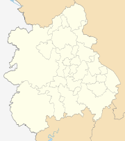 | |
| Shropshire | ||
| Staffordshire | ||
| Warwickshire | ||
| West Midlands | ||
| Worcestershire | ||