City of Wolverhampton Council
 The coat of arms of the City of Wolverhampton | |
| Motto | Out of darkness cometh light |
|---|---|
| Type | Local Government |
| Headquarters | Civic Centre |
| Location |
|
Region served | City of Wolverhampton |
Leader | Councillor Roger Lawerence |
Deputy Leader | Councillor Peter Bilston |
Mayor | Councillor Phil Page |
Deputy Mayor | Councillor Claire Darke |
Key people |
Keith Ireland – Managing Director (Head of Paid Service) Tim Johnson - Strategic Director (Place) Mark Taylor - Strategic Director (People) Kevin O'Keefe - Director of Governance (Solicitor to the City Council & Monitoring Officer) Claire Nye - Director of Finance (Section 151 Officer) Meredith Teasdale - Director of Education |
Staff | 4,600 |
| Website |
wolverhampton |
Formerly called | Wolverhampton Metropolitan Borough Council & Wolverhampton City Council |
City of Wolverhampton Council is the governing body of the City of Wolverhampton, England. The Council is still legally called Wolverhampton City Council but uses City of Wolverhampton Council as its corporate brand.
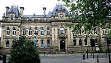
The council offices are at the imposing Civic Centre, which is located in St. Peter's Square in the City centre.[1]
The Labour Party currently control the council and have been in majority on the council since 1974, with the exceptions of 1978–1979, 1987, 1992–1994 and 2008–2010.[2] The Leader of the Council is Councillor Roger Lawrence. The Deputy Leader is Councillor Peter Bilson. The Council has a Leader and Cabinet model of executive arrangements, with each Cabinet Member having political responsibility for assigned service areas. The Council has a total of 60 Councillors (currently 51 Labour and 9 Conservative).
Councillor Phil Page of the Labour Party is the City's Mayor 2018-19 municipal year, with his Deputy who will take on the role for 2019-20 being Councillor Claire Darke of Labour Party. Visit the Mayor of City of Wolverhampton's website here
The Council's Head of Paid Service, Keith Ireland, serves as the Council's Managing Director and chairs the Authority's Strategic Executive Board of Directors comprising Tim Johnson(Strategic Director of Place); Mark Taylor (Strategic Director of People); Kevin O'Keefe (Director of Governance, Monitoring Officer and Solicitor to the City Council), Meredith Teasdale (Director of Education) and Claire Nye (Director of Finance and Section 151 Officer).
The Council swept the board at Local Government's prestigious Municipal Journal National Awards in 2017, winning Local Authority of the Year, Most Improved Local Authority of the Year, Leadership Team of the Year and Governance & Scrutiny Team of the Year.[3] Other key achievements in 2017 included the Council's Children's Services being rated as "Good" following an OFSTED inspection, the Council has been accredited with "Achieving" status for its commitment to equality & diversity following a Local Government Association peer assessment and the Council's Mayoralty team was awarded "Civic Team of the Year" by the National Association of Civic Officers.
The Council's housing stock is managed by Wolverhampton Homes.[4]
Council affiliation
| Affiliation | Members[5] | ||
|---|---|---|---|
| Current | |||
| Labour | 51 | ||
| Conservative | 9 | ||
| Total number of seats | 60 | ||
| Actual majority | 42 | ||
Wards
There are 20 wards of City of Wolverhampton Council:
| Ward name | Area (ha)/mi2 | Population (2011 census)[6] |
Population (2001 census) |
Population change |
|---|---|---|---|---|
| Bilston East | 384 hectares (1.48 sq mi) | 13,363 | 10,741[7] | +24.41% |
| Bilston North | 290 hectares (1.1 sq mi) | 12,213 | 13,527[8] | −9.71% |
| Blakenhall | 342 hectares (1.32 sq mi) | 12,022 | 11,301[9] | +6.38% |
| Bushbury North | 481 hectares (1.86 sq mi) | 11,936 | 12,021[10] | −0.71% |
| Bushbury South and Low Hill | 342 hectares (1.32 sq mi) | 14,983 | 14,103[11] | +6.24% |
| East Park | 342 hectares (1.32 sq mi) | 12,497 | 10,452[12] | +19.57% |
| Ettingshall | 417 hectares (1.61 sq mi) | 13,482 | 10,839[13] | +24.38% |
| Fallings Park | 244 hectares (0.94 sq mi) | 12,410 | 10,996[14] | +12.86% |
| Graiseley | 225 hectares (0.87 sq mi) | 12,284 | 11,691[15] | +5.07% |
| Heath Town | 270 hectares (1.0 sq mi) | 13,965 | 10,876[16] | +28.40% |
| Merry Hill | 246 hectares (0.95 sq mi) | 12,189 | 11,893[17] | +2.49% |
| Oxley | 421 hectares (1.63 sq mi) | 12,797 | 12,848[18] | −0.39% |
| Park | 385 hectares (1.49 sq mi) | 12,294 | 12,844[19] | −4.28% |
| Penn | 308 hectares (1.19 sq mi) | 12,718 | 12,392[20] | +2.63% |
| St Peter's | 496 hectares (1.92 sq mi) | 12,645 | 14,472[21] | −12.62% |
| Spring Vale | 327 hectares (1.26 sq mi) | 12,243 | 12,588[22] | −2.74% |
| Tettenhall Regis | 457 hectares (1.76 sq mi) | 11,911 | 12,000[23] | −0.74% |
| Tettenhall Wightwick | 436 hectares (1.68 sq mi) | 10,872 | 10,832[24] | +0.37% |
| Wednesfield North | 210 hectares (0.81 sq mi) | 11,235 | 10,978[25] | +2.34% |
| Wednesfield South | 437 hectares (1.69 sq mi) | 11,411 | 11,195[26] | +1.93% |
| Wolverhampton City Council area | 6,944 hectares (26.81 sq mi) | 249,470 | 236,582 | +5.45% |
A map showing the ward boundaries is available.[27]
City council election results
History

Wolverhampton gained the beginnings of modern local government in 1777, when the Wolverhampton Improvement Act was passed by Parliament. This allowed for the establishment of 125 Town Commissioners who undertook a variety of local improvement work such as punishing bear baiting, improving drainage, widening streets and by the end of the century street lighting had been provided at every street corner and over the doorway of every inn, and water supply had been improved by the sinking of ten new wells and the provision of a great water tank in the market place. Policing had been improved with the appointment of ten watchmen and attempts were also made to regulate the markets and inspect hazardous food.[28][29]
Wolverhampton was incorporated as a municipal borough in 1849 under the Municipal Corporations Act 1835.[30] The town was then made a County Borough in 1889 under the Local Government Act 1888.[30]
In 1933, the boundaries of the borough expanded, taking in areas from Cannock Rural District and Seisdon Rural District, with very little of the surrounding urban area being affected,[31] with only Heath Town Urban District being abolished.
The bulk of the urban districts of Bilston (a borough itself after 1933), Tettenhall and Wednesfield were added to the borough in 1966, along with the northern section of the urban district of Coseley and parts from the north of Sedgley and the west of Willenhall. The vast majority of these areas were traditionally part of the Parish of Wolverhampton, and were part of the original Parliamentary Borough.[31]
Wolverhampton was one of only two County Boroughs (the other being Liverpool) to have no changes made to the boundary during the 1974 reorganisation of local government, the borough already having a population larger than the 250,000 required for education authorities. This contrasted with both the Redcliffe-Maud Report, and the initial White Paper for the 1974 reforms[32] where large areas of the present South Staffordshire district were to be added to the borough. During the 1974 reforms it was placed within the West Midlands Metropolitan County.
Coat of arms
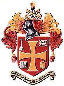
The coat of arms of City of Wolverhampton Council was granted on 31 December 1898, on the occasion of the 50th anniversary of the foundation of the council.[33]
The various symbols within the arms are representative of the history of the city. The book represents the education within the city, specifically the 16th century Wolverhampton Grammar School;[33] the woolpack represents the mediaeval woollen trade within the city;[33] the column is a representation of the Saxon pillar that can be found within the churchyard of St. Peter's Collegiate Church in the city centre;[33] whilst the keys are representative of the church itself and its dedication to St. Peter.[33] The padlock represents one of the major industries of the area at the time of the granting of the arms – that of lock-making;[33] whilst the brazier at the top is indicative of the general metal-working industries in the area.[33] The cross is ascribed to King Edgar.[33]
The motto on the coat of arms is 'Out of Darkness Cometh Light'.[33]
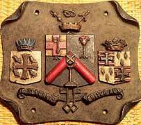
Prior to 1898 there was a former coat of arms that had been in use since 1848, though these arms were never officially granted.[34]
References
- ↑ "City of Wolverhampton Council: Contact Us". Wolverhampton City Council. Archived from the original on 23 May 2008. Retrieved 29 May 2008.
- ↑ "Wolverhampton City Council local elections 2008". BBC Online. 2 May 2008. Retrieved 29 May 2008.
- ↑ Ltd, Hemming Group. "Last year's local government winners of the MJ Achievement Awards". awards.themj.co.uk. Retrieved 2017-10-21.
- ↑ "Looking for a council house". Wolverhampton City Council. Retrieved 13 May 2011.
- ↑ "Current State of the Parties". wolverhampton.gov.uk/home. Retrieved 31 December 2015.
- ↑ "Thematic Map showing Usual Resident Population (KS101EW)". Office for National Statistics. Retrieved 4 May 2008.
- ↑ "Bilston East ward dataset – Population Density (UV02)". Office for National Statistics. Retrieved 4 May 2008.
- ↑ "Bilston North ward dataset – Population Density (UV02)". Office for National Statistics. Retrieved 4 May 2008.
- ↑ "Blakenhall ward dataset – Population Density (UV02)". Office for National Statistics. Retrieved 4 May 2008.
- ↑ "Bushbury North ward dataset – Population Density (UV02)". Office for National Statistics. Retrieved 4 May 2008.
- ↑ "Bushbury South and Low Hill ward dataset – Population Density (UV02)". Office for National Statistics. Retrieved 4 May 2008.
- ↑ "East Park ward dataset – Population Density (UV02)". Office for National Statistics. Retrieved 4 May 2008.
- ↑ "Ettingshall ward dataset – Population Density (UV02)". Office for National Statistics. Retrieved 4 May 2008.
- ↑ "Fallings Park ward dataset – Population Density (UV02)". Office for National Statistics. Retrieved 4 May 2008.
- ↑ "Graiseley ward dataset – Population Density (UV02)". Office for National Statistics. Retrieved 4 May 2008.
- ↑ "Heath Town ward dataset – Population Density (UV02)". Office for National Statistics. Retrieved 4 May 2008.
- ↑ "Merry Hill ward dataset – Population Density (UV02)". Office for National Statistics. Retrieved 4 May 2008.
- ↑ "Oxley ward dataset – Population Density (UV02)". Office for National Statistics. Retrieved 4 May 2008.
- ↑ "Park ward dataset – Population Density (UV02)". Office for National Statistics. Retrieved 4 May 2008.
- ↑ "Penn ward dataset – Population Density (UV02)". Office for National Statistics. Retrieved 4 May 2008.
- ↑ "St. Peter's ward dataset – Population Density (UV02)". Office for National Statistics. Retrieved 4 May 2008.
- ↑ "Spring Vale ward dataset – Population Density (UV02)". Office for National Statistics. Retrieved 4 May 2008.
- ↑ "Tettenhall Regis ward dataset – Population Density (UV02)". Office for National Statistics. Retrieved 4 May 2008.
- ↑ "Tettenhall Wightwick ward dataset – Population Density (UV02)". Office for National Statistics. Retrieved 4 May 2008.
- ↑ "Wednesfield North ward dataset – Population Density (UV02)". Office for National Statistics. Retrieved 4 May 2008.
- ↑ "Wednesfield South ward dataset – Population Density (UV02)". Office for National Statistics. Retrieved 4 May 2008.
- ↑ "Revised ward boundaries as of 10th June 2004" (PDF). City of Wolverhampton Council. 10 Jun 2004. Archived from the original (PDF) on 27 Sep 2009.
- ↑ Keith Farley (1985). "Wolverhampton 985 – 1985". Wolverhampton History & Heritage Society. Retrieved 8 July 2007.
- ↑ "Local Government in Wolverhampton". The History of Wolverhampton – The City and its People. 2005. Retrieved 15 July 2007.
- 1 2 "Archive Gazetter – Wolverhampton". Staffordshire County Archives. Archived from the original on 7 March 2012. Retrieved 23 July 2008.
- 1 2 "Relationships / unit history of WOLVERHAMPTON". A Vision of Britain. Archived from the original on 1 October 2007. Retrieved 15 July 2007.
- ↑ HMSO. Local Government in England: Government Proposals for Reorganisation. Cmnd. 4584
- 1 2 3 4 5 6 7 8 9 "Wolverhampton Coat of Arms – Wolverhampton History". Wolverhampton City Council. Retrieved 11 June 2008.
- ↑ Wolverhampton Borough Council Coat of Arms