Fort Good Hope
| Fort Good Hope Rádeyîlîkóé | |
|---|---|
| Charter Community | |
 | |
 Fort Good Hope  Fort Good Hope | |
| Coordinates: 66°15′31″N 128°37′43″W / 66.25861°N 128.62861°WCoordinates: 66°15′31″N 128°37′43″W / 66.25861°N 128.62861°W | |
| Country | Canada |
| Territory | Northwest Territories |
| Region | Sahtu Region |
| Constituency | Sahtu |
| Census division | Region 2 |
| Charter Community | 1 April 1995 |
| Government | |
| • Chief | Wilfred Glenn` McNeely Jr. |
| • Senior Administrative Officer | Robert Moretti |
| • MLA | Daniel McNeely |
| Area[1] | |
| • Land | 47.25 km2 (18.24 sq mi) |
| Elevation | 268 m (879 ft) |
| Population (2016)[1] | |
| • Total | 516 |
| • Density | 10.9/km2 (28/sq mi) |
| Time zone | UTC-7 (Mountain (MST)) |
| • Summer (DST) | UTC-6 (MDT) |
| Canadian Postal code | X0E 0H0 |
| Area code(s) | 867 |
| Telephone exchange | 598 |
| - Living cost | 177.5A |
| - Food price index | 166.9B |
|
Sources: Department of Municipal and Community Affairs,[2] Prince of Wales Northern Heritage Centre,[3] Canada Flight Supplement[4] ^A 2013 figure based on Edmonton = 100[5] ^B 2015 figure based on Yellowknife = 100[5] | |
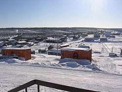
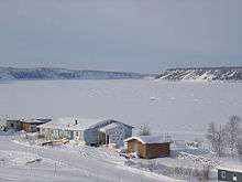
Fort Good Hope, formerly Fort Hope, also now known as the Charter Community of K'asho Got'ine), is a charter community in the Sahtu Region of the Northwest Territories, Canada. It is located on a peninsula between Jackfish Creek and the east bank of the Mackenzie River, about 145 km (90 mi) northwest of Norman Wells. The two principal languages are North Slavey and English. Hunting and trapping are two major sources of income. The Church of Our Lady of Good Hope, a National Historic Site, is located in the community. The church, completed in 1885, was once home to Father Émile Petitot.
Demographics
According to the 2016 Census the population was 516, a increase of 0.2% from the 2011 Census. In 2006 the Indigenous population was 465, of which 435 were First Nations, 20 Métis and 10 Inuit.[1] In 2017 the Government of the Northwest Territories reported that the population was 570 with an average yearly growth rate of 0.1% from 2007.[5]
| Historical population | |||||||||||||||||||||||||||||||||||||||||||||||||||||||||||||||||||||||||
|---|---|---|---|---|---|---|---|---|---|---|---|---|---|---|---|---|---|---|---|---|---|---|---|---|---|---|---|---|---|---|---|---|---|---|---|---|---|---|---|---|---|---|---|---|---|---|---|---|---|---|---|---|---|---|---|---|---|---|---|---|---|---|---|---|---|---|---|---|---|---|---|---|---|
|
| ||||||||||||||||||||||||||||||||||||||||||||||||||||||||||||||||||||||||
| Sources: NWT Bureau of Statistics (2001 - 2017)[6] | |||||||||||||||||||||||||||||||||||||||||||||||||||||||||||||||||||||||||
Transportation
The only all season access is by air, Fort Good Hope Airport, with flights operated by North-Wright Airways from Inuvik, Norman Wells and Colville Lake.[7] The community can be accessed in summer using the Mackenzie River. There is no passenger service and the route is primarily used by the Northern Transportation Company for the summer sealift. Winter access is possible via a winter road from Wrigley located further south. The NWT government is seeking federal funding to help extend the Mackenzie Highway from Wrigley to Tsiigehtchic, where it would connect with the Dempster Highway, as of winter 2014 at least eight major river crossings are in place for the new road, some of which are in use as winter crossings.
First Nations
Fort Good Hope is represented by the K’asho Go’tine Community Council and belong to the Sahtu Dene Council.[8] Through the council they are in negotiations with the Government of Canada for a land claims settlement.
Education
Fort Good Hope currently has three institutes providing some form of education. For pre-school, there is the Fort Good Hope Daycare. Elementary, junior high and senior high school students attend Chief T'Selehye School. However, if one attends Aurora College Learning Centre, located in the town, in the developmental studies program one can, if required, upgrade their marks from high school or upgrade their academic courses that is required for Aurora College admission or college and university admission.
Communication infrastructure
- Full postal service
- Satellite television
- Two radio stations
- 4G cellular service as of August 20, 2013
Climate
Fort Good Hope experiences a subarctic climate, with long, cold winters and short, warm summers. The highest temperature ever recorded was 35.0 °C (95 °F) on 20 June 1911,[9] 11 July 1920[10] and 5 July 1998.[11] The coldest temperature ever recorded was −56.1 °C (−69 °F) on 31 January 1917[12] and 4 February 1947.[13]
| Climate data for Fort Good Hope Airport, 1981–2010 normals, extremes 1907–present | |||||||||||||
|---|---|---|---|---|---|---|---|---|---|---|---|---|---|
| Month | Jan | Feb | Mar | Apr | May | Jun | Jul | Aug | Sep | Oct | Nov | Dec | Year |
| Record high °C (°F) | 6.7 (44.1) |
13.3 (55.9) |
15.6 (60.1) |
21.8 (71.2) |
30.5 (86.9) |
35.0 (95) |
35.0 (95) |
33.9 (93) |
30.6 (87.1) |
22.8 (73) |
5.4 (41.7) |
5.9 (42.6) |
35.0 (95) |
| Average high °C (°F) | −23.8 (−10.8) |
−19.7 (−3.5) |
−14.1 (6.6) |
−0.2 (31.6) |
10.5 (50.9) |
20.9 (69.6) |
22.4 (72.3) |
18.4 (65.1) |
10.2 (50.4) |
−2.3 (27.9) |
−15.9 (3.4) |
−19.8 (−3.6) |
−1.1 (30) |
| Daily mean °C (°F) | −27.8 (−18) |
−24.2 (−11.6) |
−20.0 (−4) |
−6.9 (19.6) |
4.7 (40.5) |
14.8 (58.6) |
16.7 (62.1) |
12.7 (54.9) |
5.4 (41.7) |
−5.9 (21.4) |
−19.8 (−3.6) |
−24.0 (−11.2) |
−6.2 (20.8) |
| Average low °C (°F) | −31.7 (−25.1) |
−28.7 (−19.7) |
−25.8 (−14.4) |
−13.6 (7.5) |
−1.1 (30) |
8.6 (47.5) |
10.9 (51.6) |
7.1 (44.8) |
0.5 (32.9) |
−9.4 (15.1) |
−23.7 (−10.7) |
−28.1 (−18.6) |
−11.2 (11.8) |
| Record low °C (°F) | −56.1 (−69) |
−56.1 (−69) |
−49.4 (−56.9) |
−41.7 (−43.1) |
−25.6 (−14.1) |
−5.6 (21.9) |
−2.8 (27) |
−7.2 (19) |
−17.0 (1.4) |
−38.9 (−38) |
−48.3 (−54.9) |
−55.0 (−67) |
−56.1 (−69) |
| Average precipitation mm (inches) | 19.6 (0.772) |
21.0 (0.827) |
16.4 (0.646) |
9.4 (0.37) |
11.5 (0.453) |
27.1 (1.067) |
41.3 (1.626) |
39.7 (1.563) |
33.6 (1.323) |
29.5 (1.161) |
23.2 (0.913) |
22.5 (0.886) |
294.8 (11.606) |
| Average rainfall mm (inches) | 0.0 (0) |
0.0 (0) |
0.0 (0) |
0.2 (0.008) |
6.7 (0.264) |
27.1 (1.067) |
41.3 (1.626) |
39.7 (1.563) |
27.6 (1.087) |
2.4 (0.094) |
0.0 (0) |
0.0 (0) |
144.9 (5.705) |
| Average snowfall cm (inches) | 19.7 (7.76) |
21.2 (8.35) |
16.6 (6.54) |
9.3 (3.66) |
4.9 (1.93) |
0.1 (0.04) |
0.0 (0) |
0.0 (0) |
6.0 (2.36) |
27.3 (10.75) |
23.6 (9.29) |
22.6 (8.9) |
151.2 (59.53) |
| Average precipitation days (≥ 0.2 mm) | 8.5 | 8.7 | 8.0 | 4.5 | 4.1 | 6.8 | 9.2 | 9.5 | 10.0 | 12.2 | 10.3 | 9.7 | 101.2 |
| Average rainy days (≥ 0.2 mm) | 0.0 | 0.0 | 0.0 | 0.2 | 2.4 | 6.8 | 9.2 | 9.4 | 8.3 | 1.1 | 0.0 | 0.0 | 37.3 |
| Average snowy days (≥ 0.2 cm) | 8.5 | 8.7 | 7.9 | 4.4 | 1.9 | 0.1 | 0.0 | 0.0 | 2.1 | 11.2 | 10.3 | 9.8 | 64.7 |
| Source: Environment Canada[11][14][15][9][10][12][13] | |||||||||||||
See also
References
- 1 2 3 Census Profile, 2016 Census Fort Good Hope, Chartered community (Census subdivision), Northwest Territories and Northwest Territories (Territory)
- ↑ "NWT Communities - Fort Good Hope". Government of the Northwest Territories: Department of Municipal and Community Affairs. Retrieved 2014-01-21.
- ↑ "Northwest Territories Official Community Names and Pronunciation Guide". Prince of Wales Northern Heritage Centre. Yellowknife: Education, Culture and Employment, Government of the Northwest Territories. Archived from the original on 2016-01-13. Retrieved 2016-01-13.
- ↑ Canada Flight Supplement. Effective 0901Z 19 July 2018 to 0901Z 13 September 2018.
- 1 2 3 Fort Good Hope - Statistical Profile
- ↑ Population Estimates By Community from the GNWT
- ↑ North-Wright Airways flight schedule
- ↑ Indian and Northern Affairs Canada Archived 2007-06-11 at Archive.is
- 1 2 "June 1911". Canadian Climate Data. Environment Canada. Climate ID: 2201500. Retrieved 20 May 2016.
- 1 2 "July 1920". Canadian Climate Data. Environment Canada. Climate ID: 2201500. Retrieved 20 May 2016.
- 1 2 "Fort Good Hope A" (CSV (3069 KB)). Canadian Climate Normals 1981–2010. Environment Canada. Climate ID: 2201400. Retrieved 2014-01-09.
- 1 2 "January 1917". Canadian Climate Data. Environment Canada. Climate ID: 2201500. Retrieved 20 May 2016.
- 1 2 "February 1947". Canadian Climate Data. Environment Canada. Climate ID: 2201500. Retrieved 20 May 2016.
- ↑ "Fort Good Hope 2". Canadian Climate Data. Environment Canada. Climate ID: 2201500. Retrieved 20 May 2016.
- ↑ "Fort Good Hope CS". Canadian Climate Data. Environment Canada. Climate ID: 2201450. Retrieved 20 May 2016.
External links
| Wikimedia Commons has media related to Fort Good Hope. |
| Census divisions | |||||||
|---|---|---|---|---|---|---|---|
| Former census divisions | |||||||
| Dehcho Region |
| ||||||
| Inuvik Region |
| ||||||
| North Slave Region |
| ||||||
| Sahtu Region |
| ||||||
| South Slave Region |
| ||||||
| Weather stations (outside of communities) | |||||||
| Mine sites |
| ||||||
| DEW line and NWS sites |
| ||||||
| Hudson's Bay Company trading posts | |||||||
| Former districts |
| ||||||
| |||||||