Fort Vermilion
| Fort Vermilion | ||
|---|---|---|
| Hamlet | ||
 Aerial view from north | ||
| ||
 Fort Vermilion | ||
| Coordinates: 58°23′24″N 116°01′00″W / 58.39000°N 116.01667°WCoordinates: 58°23′24″N 116°01′00″W / 58.39000°N 116.01667°W | ||
| Country |
| |
| Province |
| |
| Region | Northern Alberta | |
| Census division | 17 | |
| Specialized municipality | Mackenzie County | |
| Established | 1788 (oldest in Alberta) | |
| Government[1] | ||
| • Type | Unincorporated | |
| • Reeve | Peter F. Braun | |
| • Governing body |
Mackenzie County Council
| |
| • MP | Arnold Viersen (Cons - Peace River—Westlock) | |
| • MLA | Debbie Jabbour (NDP - Peace River) | |
| Area[2] | ||
| • Total | 6.81 km2 (2.63 sq mi) | |
| Elevation[3] | 270 m (890 ft) | |
| Population (2011)[2] | ||
| • Total | 727 | |
| • Density | 110/km2 (280/sq mi) | |
| • Dwellings | 278 | |
| Time zone | UTC−7 (MST) | |
| • Summer (DST) | UTC−6 (MDT) | |
| Postal code | T0H 1N0 | |
| Area code(s) | +1-780 | |
| Highways | Highway 88 (Bicentennial Highway) | |
| Waterways | Peace River | |
Fort Vermilion is a hamlet on the Peace River in northern Alberta, Canada, within Mackenzie County.[4]
Established in 1788, Fort Vermilion shares the title of oldest European settlement in Alberta with Fort Chipewyan.[5][6] Fort Vermilion contains many modern amenities to serve its inhabitants as well as the surrounding rural community. The municipal office of Mackenzie County, Alberta's largest municipality by land area, is located in Fort Vermilion.
The hamlet is located in census division No. 17.
History
.JPG)
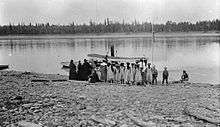
The area was inhabited by Dunneza (Beaver), Dene and later Cree first nations long before the arrival of European traders and settlers.
Named for the vermilion coloured clays lining the river banks, Fort Vermilion began as a trading community for the North West Company, upstream of the impassible Vermilion Chutes.[7] The fort was established in 1788, following the expeditions of Alexander MacKenzie. Winter residents would trade furs with the native trappers, then send the furs by river during the summer to exchange points to the east and then to Montreal. The fort was later transferred to the Hudson's Bay Company after the 1821 merger. By 1830, it was a prosperous fur trading post.[8] The first Anglican church was built in 1877.[9]
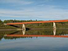
The main access to the settlements was by means of the river, using river boats and then ferries to haul materials in the summer months, when the water was not frozen. In 1903 the first steam-powered vessel to serve Fort Vermilion was the St. Charles built to navigate the 526 miles (847 km) the upper reaches of the Peace River, from Hudson's Hope to Fort Vermilion.[7] In 1974 a bridge was built over the Peace River immediately west of Fort Vermilion, effectively ending the winter isolation of the community.
The original Old Bay House, home of the chief factor, still exists and is now part of the Fort Vermilion National Historic Site. It was listed as such in 1968, for its importance as site of North West Company and Hudson's Bay Company posts.[10]
The visitor centre is hosted in a 1923 dovetailed log house. Built on the banks of the Peace River, it was moved to its present location in 1983. Another heritage building is the 1907 Clark House, built for the Hudson's Bay clerk quarters, and moved in 1994 to the present location near the visitor centre. The Trappers Shack, built in 1912, is another dovetailed log house. It was listed as a provincial historic site.[5]
Geography
Fort Vermilion is located approximately 77 kilometres (48 mi) southeast of High Level and 661 kilometres (411 mi) northwest of Edmonton on the Highway 88 (Bicentennial Highway). The hamlet of La Crete is located approximately 40 km (25 mi) southwest of Fort Vermilion on Highway 697.
The hamlet is one of the northernmost communities in the Peace River Country. Peace Country, in the aspen parkland biome, is Canada's northernmost land suitable for agriculture. The landscape is dominated by aspen, poplars and spruce, occasionally interspersed with areas of grasslands. Wildlife is abundant in the area, and includes bears, moose, deer, beavers, foxes, coyotes and Canada geese.[8]
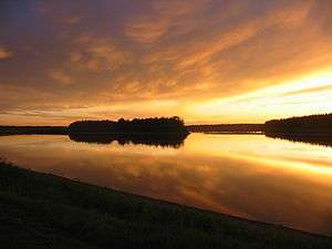
The hamlet is situated on the southern banks of the Peace River, with an elevation ranging from 255 m (837 ft) to 282 m (925 ft). The North Vermilion Settlement lies on the opposite (northern) shore of the river, while Fort Vermilion Airport is located 6 km (3.7 mi) downstream.
Climate

Despite being so high in latitude, Fort Vermilion experiences a humid continental climate, with long, cold winters and brief but fairly warm summers. Temperatures during the winter can drop to −40 °C (−40.0 °F) to −50 °C (−58.0 °F). Summer days benefit from long hours of daylight due to its northern location.[8] Mosquitoes are a hazard during the summer months.
Fort Vermilion holds the record for the coldest temperature in Canada recorded outside Yukon, when on 11 January 1911, the temperature dropped down to −61.1 °C (−78 °F).[11][12] The highest temperature ever recorded was 38.3 °C (101 °F) on 17 August 1912.[12]
| Climate data for Fort Vermilion CDA, 1961–1990 normals, extremes 1905–present | |||||||||||||
|---|---|---|---|---|---|---|---|---|---|---|---|---|---|
| Month | Jan | Feb | Mar | Apr | May | Jun | Jul | Aug | Sep | Oct | Nov | Dec | Year |
| Record high °C (°F) | 11.7 (53.1) |
11.7 (53.1) |
17.2 (63) |
28.3 (82.9) |
33.9 (93) |
36.7 (98.1) |
37.8 (100) |
38.3 (100.9) |
31.1 (88) |
26.7 (80.1) |
16.5 (61.7) |
18.3 (64.9) |
38.3 (100.9) |
| Average high °C (°F) | −18.2 (−0.8) |
−12 (10) |
−3.7 (25.3) |
7.8 (46) |
16.7 (62.1) |
21.6 (70.9) |
23.1 (73.6) |
21.3 (70.3) |
14.6 (58.3) |
6.7 (44.1) |
−6.8 (19.8) |
−15.7 (3.7) |
4.6 (40.3) |
| Daily mean °C (°F) | −22.7 (−8.9) |
−17.3 (0.9) |
−10 (14) |
1.8 (35.2) |
10.2 (50.4) |
15.0 (59) |
16.9 (62.4) |
15.0 (59) |
8.9 (48) |
2.2 (36) |
−10.5 (13.1) |
−19.8 (−3.6) |
−0.9 (30.4) |
| Average low °C (°F) | −27.3 (−17.1) |
−22.8 (−9) |
−16.2 (2.8) |
−4.2 (24.4) |
3.7 (38.7) |
8.4 (47.1) |
10.6 (51.1) |
8.7 (47.7) |
3.2 (37.8) |
−2.4 (27.7) |
−14.4 (6.1) |
−24.2 (−11.6) |
−6.4 (20.5) |
| Record low °C (°F) | −61.1 (−78) |
−57.2 (−71) |
−47.2 (−53) |
−38.9 (−38) |
−14.4 (6.1) |
−8.9 (16) |
−6.7 (19.9) |
−5.6 (21.9) |
−15 (5) |
−32 (−26) |
−43.9 (−47) |
−57.8 (−72) |
−61.1 (−78) |
| Average precipitation mm (inches) | 20.2 (0.795) |
17.5 (0.689) |
19.8 (0.78) |
18.8 (0.74) |
35.3 (1.39) |
47.1 (1.854) |
64.4 (2.535) |
54.7 (2.154) |
35.4 (1.394) |
28.1 (1.106) |
20.8 (0.819) |
19.7 (0.776) |
381.7 (15.028) |
| Average rainfall mm (inches) | 0.9 (0.035) |
0.7 (0.028) |
0.8 (0.031) |
7.6 (0.299) |
32.9 (1.295) |
47.1 (1.854) |
64.4 (2.535) |
54.7 (2.154) |
34.5 (1.358) |
16.1 (0.634) |
1.3 (0.051) |
0.9 (0.035) |
261.9 (10.311) |
| Average snowfall cm (inches) | 21.0 (8.27) |
17.5 (6.89) |
20.7 (8.15) |
11.7 (4.61) |
2.2 (0.87) |
0.0 (0) |
0.0 (0) |
0.0 (0) |
0.8 (0.31) |
10.8 (4.25) |
20.9 (8.23) |
20.2 (7.95) |
125.8 (49.53) |
| Source: Environment Canada[12][13] | |||||||||||||
Demographics

As a designated place in the 2016 Census of Population conducted by Statistics Canada, Fort Vermilion recorded a population of 639 living in 224 of its 294 total private dwellings, a change of −12.1% from its 2011 population of 727. With a land area of 5.8 km2 (2.2 sq mi), it had a population density of 110.2/km2 (285.3/sq mi) in 2016.[14]
As a designated place in the 2011 Census, Fort Vermilion had a population of 727 living in 239 of its 278 total dwellings, a 1.8% increase from its 2006 population of 714. With a land area of 6.81 km2 (2.63 sq mi), it had a population density of 106.75/km2 (276.5/sq mi) in 2011.[2]
Education
.JPG)
Two schools are located in Fort Vermilion, both administered by the Fort Vermilion School Division No. 52.[15]
Fort Vermilion Public is part of the public school system and offers education from grade 6 to grade 12. Approximately 150 students attend this school. St. Mary's Elementary functions in the Catholic school system and is a kindergarten to grade 6 school. It has approximately 145 students.
The Northern Lakes College, established in 1999, has one of its 26 campuses in Fort Vermilion. It was previously known as Alberta Vocational Centre Grouard, and offered education to First Nations students.[16]
Infrastructure
.JPG)
The Community Complex includes a hockey rink, a dance hall and a curling rink. The Fort Vermilion Heritage Centre manages 25 sites (listed as both provincial and national historic sites), including the old log houses, the Dominion Experimental Farm, First Nations and natural history exhibits.[17] Also located at the community complex is a RV waste dumping site and potable water refill location. The community complex also boasts workout facilities, a splash park, ball diamonds and playground -making it a great stop to relax and cool off on hot summer days.
St. Theresa General Hospital is a facility built in 1983, offering 26 acute-care beds and 8 long-term-care beds, as well as an emergency department. It employs approximately 76 health workers, and is administered by Alberta Health Services.[18] The Provincial Court of Alberta maintains a circuit court in Fort Vermilion,[19] with the base point located in High Level. The court used to reside in the old hospital building but now has its own facility beside St. Marys school. The old hospital building has been re-purposed as an office space for MARA (Mackenzie Applied Research Association) at the experimental farm.
The Fantasy North Golf & Country Club is a 9-hole golf course with a 150-year history. Additional facilities include a mini golf park, driving range and clubhouse.
The hamlet also has by a public library[20] and four churches. St. Theresa Catholic Church, Church of God in Christ, Faith Gospel Fellowship church and St. Lukes Anglican Church. The St. Luke's Anglican Church Cemetery dates back to 1877. Located east of the settlement is the Fort Vermilion Airport (TC LID: CEZ4), administered by Mackenzie County. It has an airport that serves the area with Provicial Air Ambulance services, as well as aerial firefighting. CanWest Air operates a base here with charter and medevac aircraft.
The Rodeo Grounds are located 5 kilometres (3.1 mi) southwest of the community, and hosts a rodeo every year in July (check for dates). The event features cattle roping and bucking broncos along with other competition. Other events and festivals held in Fort Vermilion include Canada Day celebrations, Town and Country Fair, River Daze and Arts and Crafts Show.
DA Thomas park is a day use area in Fort Vermilion that provides picnic tables with campfire spots and a boat launch. There are a number of beautiful white sandy beaches along the peace river that are accessible by boat (upstream and downstream). In North Vermilion (Buttertown) there is a popular beach accessible by road. Ask a local for directions.
Government
Fort Vermilion is in the federal riding of Peace River—Westlock, represented by MP Arnold Viersen. Prior to the 2012 redistribution of federal electoral riding boundaries, the area was part of the Peace River electoral district.
Notable residents
Fort Vermilion was home to cowboy Kenton Randle, known as "Rugged". Born 1960 and deceased 23 November 2003. Kenton was the bareback bronc rider who represented Canada at the 2002 Olympics in Salt Lake City. In November 2015 he was inducted into the Canadian Rodeo Hall of Fame as a Legend of Rodeo.
Fort Vermilion was the childhood home of writers - and brothers - Will Ferguson and Ian Ferguson. Will vividly describes his childhood there in his travel memoirs Beauty Tips from Moose Jaw. Among other things he mentions that the town was included in the 1976 version of Ghost Towns of Alberta, much to the chagrin of its residents at that time.
Dave Hancock, named 15th premier of Alberta on 23 March 2014 following the resignation of Alison Redford, grew up in Fort Vermilion.[21]
See also
References
- ↑ "Municipal Officials Search". Alberta Municipal Affairs. September 22, 2017. Retrieved September 25, 2017.
- 1 2 3 "Population and dwelling counts, for Canada, provinces and territories, and designated places, 2011 and 2006 censuses (Alberta)". Statistics Canada. 2012-02-08. Retrieved 2012-04-07.
- ↑ "Alberta Private Sewage Systems 2009 Standard of Practice Handbook: Appendix A.3 Alberta Design Data (A.3.A. Alberta Climate Design Data by Town)" (PDF) (PDF). Safety Codes Council. January 2012. pp. 212–215 (PDF pages 226–229). Retrieved October 8, 2013.
- ↑ Alberta Municipal Affairs (2010-04-01). "Specialized and Rural Municipalities and Their Communities" (PDF). Archived from the original (PDF) on 2012-02-29. Retrieved 2010-06-29.
- 1 2 Discover the Peace Country. "Hamlet of Fort Vermilion". Retrieved 2007-02-13.
- ↑ Athabasca Tribal Council - Athabasca Chipewyan First Nation Archived 1 May 2008 at the Wayback Machine.
- 1 2 3
Edward L. Affleck. "Steamboating on the Peace River" (PDF). British Columbia History. Archived from the original on 2012-12-06.
The brothers built a fleet of small primitive steamers, extending by 1903 to the waters of the Peace above the Vermilion Chutes. In that year the pint—sized sternwheeler St. Charles began to work the 526 mile stretch from Fort Vermilion to Hudson’s Hope, carrying lumber and supplies for the Mission at Fort St. John in British Columbia, as well as goods for the North-West Mounted Police.
- 1 2 3 St. Mary's School. "About Fort Vermilion". Archived from the original on 28 December 2007. Retrieved 16 February 2008.
- ↑ Clark, Edith J. Lawrence (1982). Fort Vermilion before Alberta : an early history of the Ft. Vermilion district. Erskine, Alberta: Pioneers of Ft. Vermilion. p. 14. Archived from the original on 2016-01-13.
- ↑ Parks Canada. "Fort Vermilion National Historic Site of Canada". Retrieved 2008-02-16.
- ↑ Columbo, John Robert (1995), The 1996 Canadian Global Almanac, Toronto, Ontario: Macmillan Canada, p. 22
- 1 2 3 "Fort Vermilion CDA". Canadian Climate Normals 1961–1990. Environment Canada. Retrieved 25 April 2016.
- ↑ "Fort Vermilion". Environment Canada. 22 September 2015. Retrieved 25 April 2016.
- ↑ "Population and dwelling counts, for Canada, provinces and territories, and designated places, 2016 and 2011 censuses – 100% data (Alberta)". Statistics Canada. February 8, 2017. Retrieved February 13, 2017.
- ↑ "Fort Vermilion School District". Retrieved 2007-02-13.
- ↑ "Northern Lakes College". Archived from the original on 2007-09-21. Retrieved 2008-02-15.
- ↑ Alberta Online Encyclopedia. "Fort Vermilion Heritage Centre". Retrieved 2008-08-16.
- ↑ Northern Lights Health Region. "St. Theresa General Hospital". Retrieved 2008-02-16.
- ↑ Provincial Court of Alberta. "Provincial Court Fort Vermilion". Retrieved 2008-02-16.
- ↑ "Fort Vermilion Community Library". Retrieved 2008-02-16.
- ↑ "Archived copy". Archived from the original on 1 May 2014. Retrieved 21 March 2014.
Places adjacent to Fort Vermilion | |
|---|---|