Aztec, New Mexico
| Aztec, New Mexico Kinteel (Navajo) | |
|---|---|
| County Seat | |
 Aztec Public Library (2008) | |
 Location within San Juan County and New Mexico | |
| Coordinates: 36°49′20″N 107°59′34″W / 36.82222°N 107.99278°WCoordinates: 36°49′20″N 107°59′34″W / 36.82222°N 107.99278°W[1] | |
| Country | United States |
| State | New Mexico |
| County | San Juan |
| Area | |
| • Total | 13.1 sq mi (34 km2) |
| • Land | 13 sq mi (30 km2) |
| • Water | 0.1 sq mi (0.3 km2) |
| Elevation[1] | 5,646 ft (1,721 m) |
| Population (2010)[2] | |
| • Total | 6,763 |
| • Estimate (2016)[3] | 5,960 |
| • Density | 520/sq mi (200/km2) |
| Time zone | UTC-7 (Mountain (MST)) |
| • Summer (DST) | UTC-6 (MDT) |
| ZIP code | 87410 |
| Area code | 505 |
| FIPS code | 35-05780 [1] |
| GNIS ID | 0898624 [1] |
| Website | aztecnm.gov |
Aztec (Navajo: Kinteel) is a city and county seat of San Juan County, New Mexico, United States.[1][4] As of the 2010 census, the city population was 6,763. The Aztec Ruins National Monument is located on the north side of the city.
Geography
Aztec is located at 36°49′20″N 107°59′34″W / 36.82222°N 107.99278°W (36.8222261, -107.9928455).[1][5] According to the United States Census Bureau, the city has a total area of 13.1 square miles (34 km2), of which, 13.0 square miles (34 km2) of it is land and 0.1 square miles (0.26 km2) of it (0.8%) is water.
Climate
Demographics
| Historical population | |||
|---|---|---|---|
| Census | Pop. | %± | |
| 1910 | 509 | — | |
| 1920 | 489 | −3.9% | |
| 1930 | 740 | 51.3% | |
| 1940 | 756 | 2.2% | |
| 1950 | 885 | 17.1% | |
| 1960 | 4,137 | 367.5% | |
| 1970 | 3,354 | −18.9% | |
| 1980 | 5,512 | 64.3% | |
| 1990 | 5,479 | −0.6% | |
| 2000 | 6,378 | 16.4% | |
| 2010 | 6,763 | 6.0% | |
| Est. 2016 | 5,960 | [3] | −11.9% |
| U.S. Decennial Census[7] | |||
Aztec is part of the Farmington, New Mexico Metropolitan Statistical Area.
2000 census
As of the census of 2000,[2] there are 6,378 people, 2,330 households, and 1,589 families residing in the city. The population density is 253.1/km² (655.7/mi²). There are 2,545 housing units at an average density of 101.0/km² (261.6/mi²). The racial makeup of the city is 79.23% White, 0.38% African American, 9.31% Native American, 0.14% Asian, 0.13% Pacific Islander, 7.53% from other races, and 3.29% from two or more races. 19.22% of the population are Hispanic or Latino of any race.
There are 2,330 households out of which 35.3% have children under the age of 18 living with them, 50.5% are married couples living together, 12.5% have a female householder with no husband present, and 31.8% are non-families. 27.6% of all households are made up of individuals and 11.5% have someone living alone who is 65 years of age or older. The average household size is 2.51 and the average family size is 3.06.
In the city the population is spread out with 26.6% under the age of 18, 10.7% from 18 to 24, 29.5% from 25 to 44, 20.2% from 45 to 64, and 13.0% who are 65 years of age or older. The median age is 34 years. For every 100 females, there are 104.6 males. For every 100 females age 18 and over, there are 101.1 males.
The median income for a household in the city is $33,110, and the median income for a family is $39,509. Males have a median income of $36,845 versus $17,841 for females. The per capita income for the city is $14,750. 17.4% of the population and 14.6% of families are below the poverty line. Out of the total people living in poverty, 20.6% are under the age of 18 and 15.7% are 65 or older.
Parks and recreation
The City of Aztec has 10 parks for an approximate total of 132 acres.
- Riverside Park (Community Park, 30.6 acre)
- Tiger Park (Community Park, 18.9 acre)
- Minium Park (Community Park 3.9 acre)
- Hartman Park (Sports Complex 27.8 acre)
- Cap Walls Park (Neighborhood Park 1.7 acre)
- Florence Park (Neighborhood Park 2.7 acre)
- Kokopelli Park (Neighborhood Park 0.6 acre)
- Main Avenue Courtyard (Downtown Park 0.2 acre)
- Swire-Townsend Refuge (Conservancy Area, 41.8 acre)
- Rio Animas Park (Conservancy Area 3.8 acre)
In addition, there are over 16.5 miles (26.5 km) of trails established. Trail surfaces vary from concrete sidewalks to wood mulch, gravel and earthen construction.
Government
The City of Aztec practices a Commission-Manager form of government as established in the New Mexico state statutes. The five commissioners are elected at large. The Mayor and Mayor Pro-tem are elected among the five commissioners.
Education
Aztec Municipal Schools serves the City of Aztec and rural areas in northeastern San Juan County.
Tourism
Aztec Ruins National Monument
Located within the city limits of Aztec, the Aztec Ruins National Monument is a UNESCO World Heritage site managed by the National Park Service. Visitors are allowed to take a self-guided tour through the ruins of the main roomblock and restored Great Kiva. The Ruins also offers special events and tours throughout the year.
Dinetah Pueblitos

For the more remote and off the beaten path archaeological experience, the cultural buff can explore several canyon and mesa areas which were the ancestral homelands of the Navajo people. Navajo pueblitos (also known as Dinetah Pueblitos) refer to the defensive sites along canyon rims and outcrops that the Navajo people occupied in this region during the late 17th and early 18th centuries. Many of the sites are located on Bureau of Land Management lands and require four-wheel drive and high clearance vehicles to access. Roads are often not passable when wet.
Aztec Arches
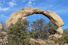
East and north of Aztec on public lands managed by the BLM are over 300 natural windows and arches. Many of these natural arches are small "windows", but there are a number of arches large enough to walk below. Over 26 canyons have been inventoried for arches and hoodoos.
Alien Run Mountain Bike Trail
Mountain biking is very popular in San Juan County, New Mexico. Aztec has over 30 miles of trails of which the most popular is the Alien Run Trail. The trail is located on BLM lands and consists of a short loop (6.1 mi easy-moderate), long loop (additional 3.4 mi moderate) and the outer limits loop (6.7 mi difficult).
Angel Peak Scenic Area
More public lands administered by the BLM, the Angel Peak Scenic Area offers a more colorful badlands and canyon landscape in contrast to the Bisti or Lybrook badlands. Three picnic areas and one campground with nine tent sites is available on a first-come, first-served basis.
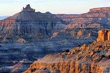
Bisti /De-Na-Zin Wilderness
.jpg)
The Bisti/De-Na-Zin Wilderness is public land managed by the BLM. Originally formed through the deposition of sediments from an ancient sea and river deltas millions of years ago, subsequent millions of years of erosion has carved out strange land forms, hoodoos and has exposed lots of petrified logs and stumps. It is also famous for several major dinosaur finds including "Spike" the Pentaceratops and "the Bisti Beast" a Bistahieversornow Tyrannosaur on display at the New Mexico Museum of Natural History and Science.
The western portion of this wilderness is known as the Bisti while the eastern portion is known as the De-Na-Zin. Each area offers slightly different geological deposits and land formations. Evening photography is the best as the sunsets provide a blazing palette of oranges and reds.
Ah-Shi-Sle-Pah Wilderness Study Area
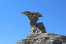
Similar to the Bisti, Ah-Shi-Sle-Pah Wilderness Study Area is located between the Bisti /De-Na-Zin Wilderness and Chaco Canyon. Also managed by the BLM, this area formed in similar fashion as the Bisti. However this region has more multi-colored sandstone deposits, strange hoodoos, petrified wood, and dinosaur bones. One of the first Pentaceratops was collected from here by Charles Sternberg.
Lybrook Badlands

Yet another area managed by the BLM, this area was formed about the same time as the Bisti and Ah-Shi-Sle-Pah. This region offers a uniquely different scale of landscape. Hoodoo in this region are massive and the terrain much greater in elevation differences, thereby exposing a greater geological time frame than the Bisti or Ah-Shi-Sle-Pah. This region is a bit more accessible due to oil field roads traversing the region. However, extreme caution is required when driving on as these roads as they are impassible when wet.
Notable people
- Alex Kennedy – NASCAR driver
- Uma Krishnaswami – Children's author
- Richard Wetherill – Southwest archaeologist; excavated a number of Chaco Canyon ruins
Gallery
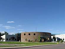 San Juan County Administration Building
.jpg) Denver and Rio Grande Western steam train at Aztec depot, 1967
Denver and Rio Grande Western steam train at Aztec depot, 1967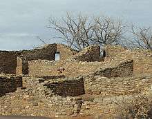 Aztec Ruins National Monument is a popular attraction in Aztec.
See also
References
- 1 2 3 4 5 6 Geographic Names Information System (GNIS) details for Aztec, New Mexico; United States Geological Survey (USGS); November 13, 1980.
- 1 2 "American FactFinder". United States Census Bureau. Archived from the original on 2015-05-12. Retrieved 2014-12-07.
- 1 2 "Population and Housing Unit Estimates". Retrieved June 9, 2017.
- ↑ "Find a County". National Association of Counties. Archived from the original on 2011-05-31. Retrieved 2011-06-07.
- ↑ "US Gazetteer files: 2010, 2000, and 1990". United States Census Bureau. 2011-02-12. Retrieved 2011-04-23.
- 1 2 3 4 "Climate Aztec - New Mexico". U.S. Climate Data. Retrieved 20 April 2017.
- ↑ "Census of Population and Housing". Census.gov. Archived from the original on May 12, 2015. Retrieved June 4, 2015.
External links
| Wikimedia Commons has media related to Aztec, New Mexico. |
Municipalities and communities of San Juan County, New Mexico, United States | ||
|---|---|---|
| Cities | 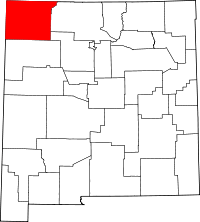 | |
| CDPs |
| |
| Unincorporated communities | ||
| Indian reservations | ||
| Footnotes | ‡This populated place also has portions in an adjacent county or counties | |