Wagon Mound National Historic Landmark
|
Wagon Mound | |
 | |
  | |
| Nearest city | Wagon Mound, New Mexico |
|---|---|
| Coordinates | 36°0′39″N 104°42′10″W / 36.01083°N 104.70278°WCoordinates: 36°0′39″N 104°42′10″W / 36.01083°N 104.70278°W |
| Area | 150 acres (61 ha) |
| Built | 1868 |
| NRHP reference # | 66000478[1] |
| NMSRCP # | 32 |
| Significant dates | |
| Added to NRHP | October 15, 1966 |
| Designated NHL | May 23, 1963[2] |
| Designated NMSRCP | December 20, 1968 |
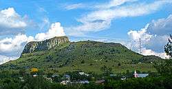
The Wagon Mound is a butte that was a major landmark for pioneers along the Cimarron Cutoff of the Old Santa Fe Trail, a well-known settlement route connecting St. Louis, Missouri and Santa Fe, New Mexico. It is located just east of Wagon Mound, New Mexico, a village named after the butte. The bute is a designated National Historic Landmark, along with Santa Clara Canyon, a site just northwest of the village where travelers on the trail frequently camped and took on water.[3] [4]
Description and history
Wagon Mound is a roughly lozenge-shaped mesa with its highest point at about 6,930 feet (2,110 m). New Mexico State Road 120 runs eastward from the village of Wagon Mound to the north of the mesa, while New Mexico State Road 271 runs southeastearly from the village to its south and west. The village is located directly west of the mesa, with two small mesas, known as the Pilot Knobs, to its west. Wagon Mound is readily visible from the Rabbit Ears, the major landmark further east on the trail.[4]
Wagon Mound was an important landmark on the Cimarron Cutoff branch of the Santa Fe Trail for several reasons. First, it was the last major landmark before reaching Santa Fe, signalling the approaching end of the journey to westbound travelers. Second, the Santa Clara Canyon, located about 2 miles (3.2 km) to the northwest, had a spring that was a reliable source of water in the desert environment. It also served as a cautionary point, because the topography of Santa Clara Canyon made groups camping their vulnerable to attacks by hostile Native Americans, with one notably large attack occurring in 1850. The route was heavily used between about 1822 and the American Civil War. Usage declined with the advent of the railroad (which followed the Santa Fe Trail route in this area) in the 1870s.[4]
See also
References
- ↑ National Park Service (2010-07-09). "National Register Information System". National Register of Historic Places. National Park Service.
- ↑ "National Historic Landmarks Survey, New Mexico" (PDF). National Park Service. Retrieved December 20, 2016.
- ↑ "Wagon Mound". National Historic Landmark summary listing. National Park Service. Retrieved 2008-06-26.
- 1 2 3 Richard Greenwood (February 10, 1975). National Register of Historic Places Inventory-Nomination: Wagon Mound / Wagon Mound (Santa Clara Spring) (pdf). National Park Service. and Accompanying two photos, from 1962 and 1974 (32 KB)
External links
| Wikimedia Commons has media related to Wagon Mound. |
| Topics | |
|---|---|
| Lists by states |
|
| Lists by insular areas | |
| Lists by associated states | |
| Other areas | |
| |