Rabbit Ears (Clayton, New Mexico)
|
Rabbit Ears | |
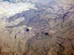 Oblique air photo facing north in August 2011 | |
  | |
| Nearest city | Clayton, New Mexico |
|---|---|
| Coordinates | 36°35′32″N 103°13′28″W / 36.59222°N 103.22444°WCoordinates: 36°35′32″N 103°13′28″W / 36.59222°N 103.22444°W |
| Area | 15,250 acres (61.7 km2)[1] |
| Built | 1868 |
| NRHP reference # | 66000499[2] |
| NMSRCP # | 203 |
| Significant dates | |
| Added to NRHP | October 15, 1966 |
| Designated NHLD | May 23, 1963[3] |
| Designated NMSRCP | November 6, 1970 |
The Rabbit Ears are a pair of mountain peaks in northeastern New Mexico, United States, north of the city of Clayton. The two peaks were a distinctive landmark along the Cimarron Cutoff of the Santa Fe Trail, and major route for westbound settlers in the 19th century. The formation was designated a National Historic Landmark in 1963.[1][3]
Description
The Rabbit Ears are part of a formation known as the Clayton Complex, an area of elevated terrain north of Clayton and south of the state line between New Mexico and Colorado. Its principal features are two peaks that are a regular presence on the landscape, especially when approached from the east. They are called Rabbit Ears Mountain and Mount Clayton, although the latter has also been historically called the Round Mound.[1] Rabbit Ears Mountain, which has two peaks, is located directly north of Clayton, and is skirted to the south and west by New Mexico State Road 370. Mount Clayton lies to its west, south of the junction of United States Route 85 and New Mexico State Road 453.
The Cimarron Cutoff of the Santa Fe Trail was one of two major branches of the Santa Fe Trail, a major 19th-century settlement route connecting Kansas City, Missouri and Santa Fe, New Mexico. Its route branched from the Mountain Route near Fort Dodge, roughly following the watershed of the Cimarron River into what is now northeastern New Mexico, where it then went southwesterly toward Santa Fe. The eastern portion of the route is roughly covered by present-day United States Route 56 and United States Route 412.
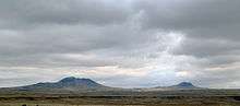
The Rabbit Ears were a key landmark because they were a highly visible feature of the landscape for more than 30 miles (48 km), and because they were one of the signs of a sure water supply across that entire area. As a consequence, there are three areas that were regularly used as camp sites by westbound travelers near the two mountains. McNees Crossing on Corrumpa (or McNees) Creek, Turkey Creek Camp on what is now called Alamos Creek, and Rabbit Ears Camp on Cienequilla Creek. Each of these creeks ran reliably in the spring, and continued to provide water even after they stopped running fully. Camps would be located along their banks, their exact locations varying based on water availability. Remnant trail ruts are visible in each of these areas.[1]
The Rabbit Ears formation figures prominently in Louis L'Amour's novel Mustang Man.
See also
![]()
![]()
References
- 1 2 3 4 Richard Greenwood (December 31, 1981). "National Register of Historic Places Inventory-Nomination: Rabbit Ears (Clayton Complex) / Clayton Complex" (pdf). National Park Service. and Accompanying two photos, from 1975 (32 KB)
- ↑ National Park Service (2010-07-09). "National Register Information System". National Register of Historic Places. National Park Service.
- 1 2 "Rabbit Ears". National Historic Landmark summary listing. National Park Service. Retrieved 2008-06-04.
External links

- Photo of Rabbit Ears Mountain
| Topics | |
|---|---|
| Lists by states |
|
| Lists by insular areas | |
| Lists by associated states | |
| Other areas | |
| |