Monte Spinarda
| Monte Spinarda | |
|---|---|
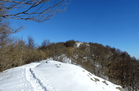 Monte Spinarda in winter | |
| Highest point | |
| Elevation | 1,357 m (4,452 ft) [1] |
| Prominence | 403 m (1,322 ft) [2] |
| Coordinates | 44°13′39.47″N 08°04′10.52″E / 44.2276306°N 8.0695889°ECoordinates: 44°13′39.47″N 08°04′10.52″E / 44.2276306°N 8.0695889°E |
| Geography | |
 Monte Spinarda Location in the Alps | |
| Location | Liguria/Piemonte, Italy |
| Parent range | Ligurian Alps |
| Climbing | |
| First ascent | ancestral |
| Easiest route | from Colle del Quazzo or Calizzano |
Monte Spinarda is a 1,357-metre (4,452 ft) mountain of the Ligurian Alps, in Italy.
Geography
The mountain belongs to the Ligurian Alps and is located between the province of Savona (Liguria, south) and the province of Cuneo (Piedmont, north). Monte Spinarda is the tripoint where the Ligurian comune of Calizzano and the Piedmontese ones of Garessio and Priola meet. Is located on the drainage divide between Tanaro and Bormida valleys. In the SOIUSA (International Standardized Mountain Subdivision of the Alps) it belongs to the Ligurian Prealps and, within them, to Monte Carmo group and Dorsale Spinarda-Sotta subgroup (SOIUSA code:I/A-1.I-A.2.b).[3]
Geology
The Anfiboliti di monte Spinarda, an outcrop of amphibolites recordered in the Italian official geologic map[4], was named after the mountain.
History
The area surrounding Monte Spinarda was involved by wartime operations linked to the Italian campaigns of Napoleone Bonaparte and in 1799 the Frenche Army occupied its summit. Nearby, in a place called Vignale, during the XIX Century mineralogist found some gold in the form of sulphate.[5]
Access to the summit
The summit of Monte Spinarda can be easily reached on foot by Colle del Quazzo[6] or, with a longer walk, from Calizzano[7]. During snowy winters the summit can also be accessed with snowshoes. The hike is appreciated not only for the good views on the surrounding mountains, but also for its low risk of avalanches[8].
Conservation
Monte Spinarda slopes are mainly covered with beech woods and shrubs. Its Ligurian side belongs to the SIC (Site of Community Importance) called Monte Spinarda - Rio Nero - code IT1323014.[9]
Maps
- Cartografia ufficiale italiana in scala 1:25.000 e 1:100.000 (Map). Istituto Geografico Militare. Retrieved 2018-03-03.
- Carta dei sentieri e stradale scala 1:25.000 n. 19 Bassa val Tanaro Val Bormida e Cebano (Map). Ciriè: Fraternali editore.
References
![]()
- ↑ Italian official map 1:25.00 of Istituto Geografico Militare (on-line on www.pcn.minambiente.it)
- ↑ key col: saddle east of Colle San Bernardo at 954 m
- ↑ Marazzi, Sergio (2005). Atlante Orografico delle Alpi. SOIUSA (in Italian). Priuli & Verlucca. ISBN 978-88-8068-273-8.
- ↑ Servizio geologico (1971). Note illustrative della carta geologica d'Italia alla scala 1:100.000 (in Italian). 92-93. Nuova tecnica grafica. p. 5. Retrieved 2018-02-22.
- ↑ Casalis, Goffredo (1847). Dizionario geografico-storico-statistico-commerciale degli stati del Redi Sardegna (in Italian). Maspero. p. 755. Retrieved 2018-02-22.
- ↑ "Spinarda (Monte) dal Colle Case Quazzo e il Bric Meriano" (in Italian). Retrieved 2018-02-23.
- ↑ "Spinarda (Monte) Traversata ad anello del Monte Spinarda" (in Italian). Retrieved 2018-02-23.
- ↑ "Spinarda (Monte) da Colle del Quazzo" (in Italian). Retrieved 2018-02-23.
- ↑ "Monte Spinarda - Rio Nero" (PDF) (in Italian). Regione Liguria. Retrieved 2018-02-21.