Monte Reixa
| Monte Reixa | |
|---|---|
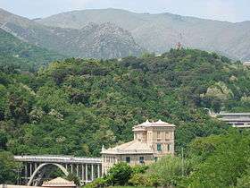 Monte Reixa from Voltri | |
| Highest point | |
| Elevation | 1,183 m (3,881 ft) [1] |
| Coordinates | 44°27′03″N 8°40′01″E / 44.45083°N 8.66694°ECoordinates: 44°27′03″N 8°40′01″E / 44.45083°N 8.66694°E |
| Geography | |
 Monte Reixa Location in Italy | |
| Location | Liguria, Italy |
| Parent range | Ligurian Appennines |
Monte Reixa is a mountain in Liguria, northern Italy, part of the Ligurian Appennines.
Geography
The mountain stands on the Adriatic / Ligurian drainage divide between Passo del Faiallo and Monte Beigua. It is located between the provinces of Genova and Savona, in Liguria, and represents the tripoint where the municipalities of Sassello, Arenzano and Genova meet.[2] From its northern slopes rises the Orba, a relevant stream of Tanaro basin.
Nature conservation
Monte Reixa belongs to the Parco naturale regionale del Beigua (Beigua Natural Regional Park).[3]
Access to the summit
The mountain is easily accessible by signposed traks departing from Passo del Faiallo or Voltri.[4]
The Alta Via dei Monti Liguri, a long-distance trail from Ventimiglia (province of Imperia) to Bolano (province of La Spezia), passes very close to the mountain's summit.[5]
References
- ↑ Istituto Geografico Centrale - Carta dei sentieri 1:50.000 n. 16 Genova - Varazze -Ovada
- ↑ Limiti Amministrativi (Comunali, Provinciali, Regionali) sc. 1:25000 - ed. 2011; Regione Liguria, on-line su geoportale.regione.liguria.it
- ↑ "Mappa del Parco". www.parcobeigua.it. Retrieved 2016-05-01.
- ↑ "Reixa m. 1183 Rocca Vaccaria m. 1167". www.escursioniliguria.it (in Italian). Retrieved 2016-05-01.
- ↑ "Tappa n. 20". www.altaviadeimontiliguri.it (in Italian). Associazione Alta Via dei Monti Liguri. Retrieved 2016-05-01.
![]()