Regensburg (district)
| Regensburg | |
|---|---|
| District | |
.svg.png) | |
| Country |
|
| State | Bavaria |
| Adm. region | Upper Palatinate |
| Capital | Regensburg |
| Government | |
| • District admin. | Tanja Schweiger (Free Voters) |
| Area | |
| • Total | 1,396 km2 (539 sq mi) |
| Population (31 December 2017)[1] | |
| • Total | 192,200 |
| • Density | 140/km2 (360/sq mi) |
| Time zone | UTC+01:00 (CET) |
| • Summer (DST) | UTC+02:00 (CEST) |
| Vehicle registration | R |
| Website | landkreis-regensburg.de |
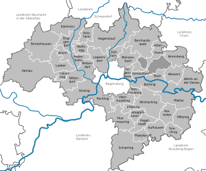
Regensburg is a Landkreis (district) in Bavaria, Germany. It is bounded by (from the north and clockwise) the districts of Schwandorf, Cham, Straubing-Bogen, Kelheim and Neumarkt. The city of Regensburg is enclosed by, but does not belong to the district; it is nonetheless its administrative seat.
History
The region became a part of Bavaria in the late 12th century, when the line of the counts of Regensburg and Stefling came to an end. While Regensburg became a Free Imperial City (meaning subordinate to the emperor only), the surrounding lands were Bavarian property.
While the district dates back to medieval times, its present shape was established in 1972.
Geography
The district is located on either side of the Danube. Another major river is the Regen which joins the Danube in Regensburg. In its northernmost parts the district is occupied by the foothills of the Bavarian Forest.
Coat of arms
 |
The coat of arms displays:
|
Towns and municipalities
| Towns | Municipalities | |
|---|---|---|
References
- ↑ "Fortschreibung des Bevölkerungsstandes". Bayerisches Landesamt für Statistik und Datenverarbeitung (in German). September 2018.
External links
| Wikimedia Commons has media related to Landkreis Regensburg. |
- Official website (German)