Tysfjorden
| Tysfjorden Divtasvuodna | |
|---|---|
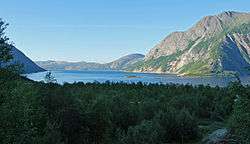 View of the Tysfjorden from Musken | |
| Location | Tysfjord, Nordland |
| Coordinates | 68°11′06″N 16°10′42″E / 68.1851°N 16.1784°ECoordinates: 68°11′06″N 16°10′42″E / 68.1851°N 16.1784°E |
| Basin countries | Norway |
| Max. length | 62 kilometres (39 mi) |
| Max. depth | 897 metres (2,943 ft) |
| Islands | Hulløya |
| Settlements |
Bognes, Drag, Kjøpsvik, Musken, Storå, and Rørvika |
Tysfjorden (Lule Sami: Divtasvuodna, English: Tys Fjord[1][2][3]) is a fjord in the municipality of Tysfjord in Nordland county, Norway. The fjord stretches southwards from Korsnes along the Ofoten fjord all the way to Hellmobotn, about 62 kilometres (39 mi) to the southeast (near the border with Sweden). The island of Hulløya is located about halfway through the fjord. Tysfjorden is the deepest fjord in Northern Norway reaching to 897 metres (2,943 ft) below sea level near Hulløya. There is no bridge or tunnel crossing the fjord, and no road passing the end of it inside Norway. The fjord ends 6 km from the border to Sweden. There are regular ferry crossings over the fjord from Bognes to Skarberget and from Drag to Kjøpsvik.[4]
See also
References
- ↑ Emanuelsson, Urban. 2009. The Rural Landscapes of Europe: How Man Has Shaped European Nature. Stockholm: Swedish Research Council Formas, p. 247.
- ↑ Merriam-Webster's Geographical Dictionary. 1997. Springfield, MA: Merriam-Webster, p. 1212.
- ↑ Storrusten, Erling. 1998. Hurtigruten: The World's Most Beautiful Sea Voyage. Narvik: Ofotens og Vesteraalens Dampskibsselskab, p. 69.
- ↑ Store norske leksikon. "Tysfjorden" (in Norwegian). Retrieved 2012-05-11.
External links

This article is issued from
Wikipedia.
The text is licensed under Creative Commons - Attribution - Sharealike.
Additional terms may apply for the media files.