Kelheim
| Kelheim | ||
|---|---|---|
 | ||
| ||
 Kelheim Location of Kelheim within Kelheim district 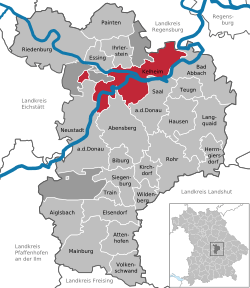 | ||
| Coordinates: 48°55′N 11°52′E / 48.917°N 11.867°ECoordinates: 48°55′N 11°52′E / 48.917°N 11.867°E | ||
| Country | Germany | |
| State | Bavaria | |
| Admin. region | Lower Bavaria | |
| District | Kelheim | |
| Government | ||
| • Mayor | Horst Hartmann (SPD) | |
| Area | ||
| • Total | 76.76 km2 (29.64 sq mi) | |
| Elevation | 343 m (1,125 ft) | |
| Population (2017-12-31)[1] | ||
| • Total | 16,716 | |
| • Density | 220/km2 (560/sq mi) | |
| Time zone | CET/CEST (UTC+1/+2) | |
| Postal codes | 93301–93309 | |
| Dialling codes | 09441 | |
| Vehicle registration | KEH | |
| Website | www.kelheim.de | |

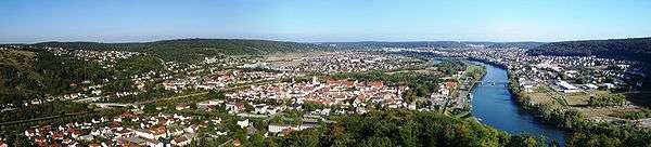
Kelheim is a town and municipality in Bavaria, Germany. It is the capital of the district Kelheim and is situated at the confluence of Altmühl and Danube. Kelheim has a population of around 15,750.
History
Kelheim is the site of a large Iron Age oppidum from the La Tène period, which has been tentatively identified with the Celtic city of Alcimoennis mentioned by Ptolemy in his Geography. The ramparts of the fort cross the promontory between the rivers Altmühl and Danube. There is an inner defensive line enclosing 60 ha near the confluence, then a long outer rampart enclosing an enormous area of 630 ha. A small promontory fort on the other bank of the Danube has a series of short linear ramparts protecting a settlement in the bend of a meander. This is aligned with the end of the outer rampart on the far bank, dominating traffic on the river. Kelheim has given its name to the pfostenschlitzmauer style of rampart construction characterized by vertical wooden posts set into the stone facing.
Kelheim was first mentioned in the 9th century. At this time it was the seat of a count (Graf). According to a tradition of Braunau in Rohr Abbey Kelheim has got borough rights in 1151.
G. Schneider & Sohn has a large weissbier brewery in the city.
Culture and sights

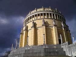
- Hall of Liberation on the Michelsberg (built by Leo von Klenze)
- Danube Gorge and Weltenburg Abbey, Wipfelsfurt and Klösterl.
- Kelheim is the home of the G._Schneider_&_Sohn brewing company.
Born in Kelheim
- Otto I, Duke of Bavaria (c. 1117-1183), Duke of Bavaria
- Louis I, Duke of Bavaria (1173-1231), Duke of Bavaria
- Otto II, Duke of Bavaria (1206-1253), Duke of Bavaria
- Albert II, Duke of Bavaria (1368-1397), Governor in the Lower Bavaria part of the duchy of Bavaria
- Friedrich L. Bauer (* 1924), pioneer of computer science
- Fritz Fischer (* 1956), a former biathlete
- Stephan Ebn (* 1978), drummer and music producer
- Thomas Paulus (* 1982), footballer
- Philipp Heerwagen (* 1983), football goalkeeper
- Daniel Brodmeier (* 1987), sportsman
References
- ↑ "Fortschreibung des Bevölkerungsstandes". Bayerisches Landesamt für Statistik und Datenverarbeitung (in German). September 2018.
External links
| Wikimedia Commons has media related to Kelheim. |
- Official website

- Kelheim360.de - Virtual 360° Panoramic Tour of old Town Kelheim
Towns and municipalities in Kelheim (district) | ||
|---|---|---|