Kakamega County
| Kakamega County | |||
|---|---|---|---|
| County | |||
| |||
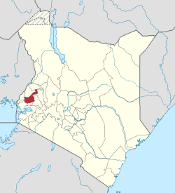 Location in Kenya | |||
| Country |
| ||
| Formed | March 4th 2013 | ||
| Capital | Kakamega | ||
| Government | |||
| • Governor | Wycliffe Oparanya | ||
| Area | |||
| • Total | 3,033.8 km2 (1,171.4 sq mi) | ||
| Population (2009) | |||
| • Total | 1,660,651 [1] | ||
| Time zone | UTC+3 (EAT) | ||
| Website | kakamega.go.ke | ||

Kakamega County is a county in the former Western Province of Kenya. Its capital and largest town is Kakamega. It has a population of 1,660,651 and an area of 3,033.8 km².
Divisions
| Local authorities (councils) | |||
| Authority | Type | Population* | Urban pop.* |
|---|---|---|---|
| Kakamega | Municipality | 73,607 | 57,128 |
| Malava | Town | 46,614 | 1,704 |
| Kakamega County | County | 483,201 | 0 |
| Total | - | 603,422 | 58,832 |
| * 1999 census. Source: | |||
| Administrative divisions | |||
| Division | Population* | Urban pop.* | Headquarters |
|---|---|---|---|
| Ikolomani | 92,104 | 0 | Ikolomani |
| Ileho | 32,545 | 0 | Kambili |
| Kabras | 149,510 | 1,530 | Malava |
| Kakamega municipality | 74,115 | 51,770 | Kakamega |
| Lurambi | 85,863 | 0 | Shisilu |
| Navakholo | 65,337 | 0 | Navakholo |
| Shinyalu | 103,948 | 0 | Shinyalu |
| Total | 603,422 | 53,300 | - |
| * 1999 census. Sources: , , | |||
The county has twelve constituencies (2013):
- Lugari Constituency
- Likuyani Constituency
- Malava Constituency
- Lurambi Constituency
- Navakholo Constituency
- Mumias West Constituency
- Mumias East Constituency
- Matungu Constituency
- Butere Constituency
- Khwisero Constituency
- Shinyalu Constituency
- Ikolomani Constituency
The Mumias Constituency was divided intp Mumias West and Mumias East.
Services and Urbanisation
| County | Stats for the County (Percent) | ||||||||
|---|---|---|---|---|---|---|---|---|---|
| Urbanisation | 15.2 | ||||||||
| Literacy | 72.7 | ||||||||
| Attending School (15-18 Yrs) | 76.3 | ||||||||
| Paved Roads | 4.9 | ||||||||
| Good Roads | 54.1 | ||||||||
| Electricity Access | 5.6 | ||||||||
| Poverty Rate | 53 | ||||||||
|
Stats for the County | |||||||||
Source: USAid Kenya
Villages and settlements
References
- ↑ "Kenya Census 2009". Retrieved 1 November 2016.
Coordinates: 0°17′00″N 34°45′00″E / 0.283333°N 34.75°E
This article is issued from
Wikipedia.
The text is licensed under Creative Commons - Attribution - Sharealike.
Additional terms may apply for the media files.