Kajiado County
| Kajiado County | |||
|---|---|---|---|
| County | |||
| |||
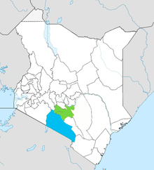
 Location in Kenya | |||
| Country |
| ||
| Formed | March 4th 2013 | ||
| Capital | Kajiado | ||
| Government | |||
| • Governor | Joseph Ole Lenku | ||
| Area | |||
| • Total | 21,292.7 km2 (8,221.2 sq mi) | ||
| Population (2009) | |||
| • Total | 687,312 [1] | ||
| Time zone | UTC+3 (EAT) | ||
| Website | kajiado.go.ke | ||

Kajiado County is a county in the former Rift Valley Province of Kenya. It has a population of 687,312 and an area of 21,292.7 km². The county borders Nairobi and extends to the Tanzania border further south. The county capital is Kajiado but the largest town is Ngong. Its main tourist attraction is wildlife.
Administration
| Local authorities (councils) | |||
| Authority | Type | Population | Urban pop. size |
|---|---|---|---|
| Kajiado | Town | 12,204 | 9,128 |
| Olkejuado | County | 393,850 | 71,223 |
| Total | - | 406,054 | 80,351 |
| * 1999 census. Source: | |||
The county is divided into seven administrative divisions. The newly created Isinya division is not included in the following table based on 1999 census:
| Administrative divisions | |||
| Division | Population* | Urban pop.* | Headquarters |
|---|---|---|---|
| Central | 69,402 | 16,444 | Kajiado |
| Loitokitok | 95,430 | 7,495 | |
| Magadi | 20,112 | 0 | Magadi |
| Mashuru | 35,666 | 2,248 | Mashuru |
| Namanga | 35,673 | 5,503 | Namanga |
| Ngong | 149,771 | 20,657 | Ngong |
| Total | 406,054 | 38,299 | - |
| * 1999 census. Sources: , , | |||
Constituencies
Services
| County | Stats for the County (Percent) | ||||||||
|---|---|---|---|---|---|---|---|---|---|
| Literacy | 55.4 | ||||||||
| Attending School (15-18 Yrs) | 44.9 | ||||||||
| Paved Roads | 5.9 | ||||||||
| Good Roads | 38.4 | ||||||||
| Electricity Access | 39.8 | ||||||||
|
Stats for the County | |||||||||
Source: USAid Kenya
Nairobi Metro
Kajiado County is within Greater Nairobi which consists of 4 out of 47 counties in Kenya but the area generates about 60% of the nation's wealth.[2][3] The counties are:
| Area | County | Area (km2) | Population Census 2009 | Cities/Towns/Municipalities in the Counties |
|---|---|---|---|---|
| Core Nairobi | Nairobi County | 694.9 | 3,138,369 | Nairobi |
| Northern Metro | Kiambu County | 2,449.2 | 1,623,282 | Kiambu, Thika, Limuru, Ruiru, Karuri, Kikuyu |
| Southern Metro | Kajiado County | 21,292.7 | 687,312 | Kajiado, Olkejuado, Bissil, Ngong, Kitengela, Kiserian, Ongata Rongai |
| Eastern Metro | Machakos County | 5,952.9 | 1,098,584 | Kangundo-Tala, Machakos, Athi River |
| Totals | Nairobi Metro | 30,389.7 | 6,547,547 |
Source: NairobiMetro/ Kenya Census
Stats
Urbanisation
| County | Urbanisation in Nairobi Metro (Percent) | ||||||||
|---|---|---|---|---|---|---|---|---|---|
| Nairobi County | 100 | ||||||||
| Kiambu County | 60.8 | ||||||||
| Machakos County | 52 | ||||||||
| Kajiado County | 41.4 | ||||||||
32.3 | |||||||||
|
Urbanisation by County within Nairobi Metro | |||||||||
Source: OpenDataKenya
Wealth/Poverty Level
| County | Poverty Level in Nairobi Metro (Percent) | ||||||||
|---|---|---|---|---|---|---|---|---|---|
| Kajiado County | 11.6 | ||||||||
| Kiambu County | 21.8 | ||||||||
| Nairobi County | 22 | ||||||||
| Machakos County | 59.6 | ||||||||
45.9 | |||||||||
|
Poverty level by County | |||||||||
Source: OpenDataKenya Worldbank
See also
- Amboseli Reserve is in the Kajiado County
- Nyiri Desert, a high proportion of the county lies in the desert
- Kitengela, a plain and a town of the same name in Kajiado County
See also
References
- ↑ "Kenya Census 2009 - Census - Kenya". Scribd. Retrieved 20 April 2018.
- ↑ http://196.200.27.243:8080/xmlui/bitstream/handle/123456789/111/Nairobi.pdf?sequence=3%5Bpermanent+dead+link%5D
- ↑ http://www.nairobimetro.go.ke/index.php?option=com_docman&task=doc_download&gid=43&Itemid=90%5Bpermanent+dead+link%5D.
External links
- https://web.archive.org/web/20060518005113/http://www.kajiado-district-dev-trust.org.uk/
- https://web.archive.org/web/20070402092415/http://www.kajiadochildrenshome.com/
Nairobi metropolitan area | ||
|---|---|---|
Population - 7.8 million | ||
| Counties | 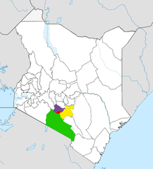 | |
| Major city 3.8 million | ||
| Urban Centres over 200K | ||
| Other major Urban Centres | ||
| Future developments | ||