Tsunan
| Tsunan 津南町 | |||
|---|---|---|---|
| Town | |||
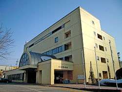 Tsunan town hall | |||
| |||
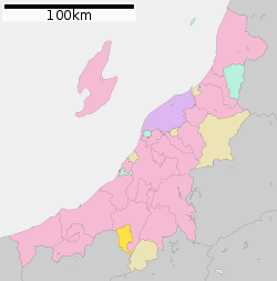 Location of Tsunan in Niigata | |||
 Tsunan | |||
| Coordinates: 37°0′51.4″N 138°39′9.1″E / 37.014278°N 138.652528°ECoordinates: 37°0′51.4″N 138°39′9.1″E / 37.014278°N 138.652528°E | |||
| Country | Japan | ||
| Region | Chūbu (Kōshin'etsu) (Hokuriku) | ||
| Prefecture | Niigata | ||
| District | Nakauonuma | ||
| Area | |||
| • Total | 170.21 km2 (65.72 sq mi) | ||
| Population (September 2018) | |||
| • Total | 9,725 | ||
| • Density | 57/km2 (150/sq mi) | ||
| Time zone | UTC+9 (Japan Standard Time) | ||
| Symbols | |||
| • Tree | Paulownia tomentosa | ||
| • Flower | Chrysanthemum morifolium | ||
| • Bird | Japanese bush-warbler | ||
| Phone number | 025-765-3111 | ||
| Address | 585 Shimofunato, Tsunan-machi, Nakauonuma-gun, Niigata-ken 949-8201 | ||
| Website | Official website | ||


Tsunan (津南町 Tsunan-machi) is a town located in Niigata Prefecture, Japan. As of 30 September 2018, the town had an estimated population of 9,725 in 3555 households [1], and a population density of 57.9 persons per km². The total area of the town was 170.21 square kilometres (65.72 sq mi).
Geography
Tsunan is located in southwestern Niigata Prefecture, in a mountainous area bordering northern Nagano Prefecture. Due to its geographical location between the Sea of Japan and the surrounding Japanese Alps, it has one of the highest annual snowfalls in Japan. There are numerous ski resorts within the region. Mount Naeba (2143 meters) is partly located within the town limits.
Surrounding municipalities
Climate
Tuscan has a Humid climate (Köppen Cfa) characterized by warm, wet summers and cold winters with heavy snowfall. The average annual temperature in Tsunan is 12.3 °C. The average annual rainfall is 1918 mm with September as the wettest month.The temperatures are highest on average in August, at around 25.4 °C, and lowest in January, at around 0.2 °C.[2]
| Climate data for Tsunan, Niigata (1981-2010) | |||||||||||||
|---|---|---|---|---|---|---|---|---|---|---|---|---|---|
| Month | Jan | Feb | Mar | Apr | May | Jun | Jul | Aug | Sep | Oct | Nov | Dec | Year |
| Average high °C (°F) | 1.7 (35.1) |
2.2 (36) |
5.7 (42.3) |
13.2 (55.8) |
19.8 (67.6) |
23.2 (73.8) |
26.5 (79.7) |
28.4 (83.1) |
23.6 (74.5) |
17.4 (63.3) |
11.4 (52.5) |
5.2 (41.4) |
14.9 (58.8) |
| Daily mean °C (°F) | −1.4 (29.5) |
−1.3 (29.7) |
1.7 (35.1) |
8.0 (46.4) |
14.4 (57.9) |
18.7 (65.7) |
22.2 (72) |
23.6 (74.5) |
19.2 (66.6) |
13.0 (55.4) |
7.0 (44.6) |
1.6 (34.9) |
10.6 (51) |
| Average low °C (°F) | −4.7 (23.5) |
−5.2 (22.6) |
−2.3 (27.9) |
3.3 (37.9) |
9.4 (48.9) |
14.8 (58.6) |
18.7 (65.7) |
19.8 (67.6) |
15.5 (59.9) |
9.0 (48.2) |
3.2 (37.8) |
−1.5 (29.3) |
6.7 (44) |
| Average precipitation mm (inches) | 235.9 (9.287) |
157.0 (6.181) |
116.8 (4.598) |
79.7 (3.138) |
102.2 (4.024) |
136.1 (5.358) |
184.4 (7.26) |
152.9 (6.02) |
177.2 (6.976) |
151.1 (5.949) |
164.2 (6.465) |
218.1 (8.587) |
1,875.6 (73.843) |
| Average snowfall cm (inches) | 443 (174.4) |
320 (126) |
208 (81.9) |
75 (29.5) |
4 (1.6) |
0 (0) |
0 (0) |
0 (0) |
0 (0) |
0 (0) |
27 (10.6) |
272 (107.1) |
1,349 (531.1) |
| Mean monthly sunshine hours | 68.6 | 82.4 | 113.6 | 166.8 | 181.2 | 140.3 | 138.8 | 174.7 | 119.6 | 123.4 | 105.5 | 84.9 | 1,499.8 |
| Source: Japan Meteorological Agency | |||||||||||||
Demographics
Per Japanese census data,[3] the population of Tsunan has declined steadily over the past 40 years.
| Census Year | Population |
|---|---|
| 1970 | 16,092 |
| 1980 | 13,841 |
| 1990 | 12,955 |
| 2000 | 12,389 |
| 2010 | 10,881 |
History
The area of present-day Tsunan was part of ancient Echigo Province and was tenryō territory under the direct control of the Tokugawa shogunate in the Edo period. Following the Meiji restoration, the area was organised into various villages within Nakauonuma District, Niigata The town of Tsunan was established on January 1, 1955 by the merger of the villages of Tomaru, Kamigō, Ashigasaki, Akinari, Nakafukami and Shimofunato.
Economy
The local economy is dominated by agriculture. The area is known for its rice, sake, tomatoes, sunflowers, and buckwheat noodles. The town is also within commuting distance of neighbouring Tōkamachi.
Education
Tsunan has three public elementary schools and one public middle school operated by the town government. There is one public high school operated by the Niigata Prefecture Board of Education.
Transportation
Railway
Highway
Local attractions
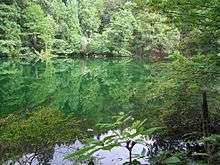
- Ryu-ga-kubo, one of the 100 Famous Springs of Japan
- Nishiotaki Dam
- Echigo-Tsumari Art Triennial
References
External links

- Official Website (in Japanese)
| Wards of Niigata | ||
|---|---|---|
| Special cities | ||
| Cities | ||
| Districts | ||