Tōkamachi
| Tōkamachi 十日町市 | |||
|---|---|---|---|
| City | |||
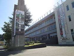 Tōkamachi City Hall | |||
| |||
 Location of Tōkamachi in Niigata | |||
 Tōkamachi | |||
| Coordinates: 37°7′39.1″N 139°45′20.6″E / 37.127528°N 139.755722°ECoordinates: 37°7′39.1″N 139°45′20.6″E / 37.127528°N 139.755722°E | |||
| Country | Japan | ||
| Region | Chūbu (Kōshin'etsu) (Hokuriku) | ||
| Prefecture | Niigata | ||
| Government | |||
| • Mayor | Yoshifumi Sekiguchi[1] | ||
| Area | |||
| • Total | 590.39 km2 (227.95 sq mi) | ||
| Population (September 30, 2018) | |||
| • Total | 53,333 | ||
| • Density | 90/km2 (230/sq mi) | ||
| Time zone | UTC+9 (Japan Standard Time) | ||
| Symbols | |||
| • Tree | Fagus crenata | ||
| • Flower | Lilium | ||
| • Bird | Swan | ||
| Phone number | 025-757-3111 | ||
| Address | 3-3 Chitose, Tokamachi-shi, Niigata-ken 948-8501 | ||
| Website | Official website | ||


Tōkamachi (十日町市 Tōkamachi-shi) is a city located in Niigata Prefecture, Japan. As of 30 September 2018, the city had an estimated population of 53,333 in 19,823 households [2], and a population density of 91.6 persons per km². The total area of the city was 590.39 square kilometres (227.95 sq mi), although some borders of the city are not well defined. Tōkamachi derives its name from the fact that a market was held every tenth day of the month. Similarly, the nearby former town of Muikamachi had its own local market held on days ending in six each month.[3]
Geography
Tōkamachi is located in an inland region of southwest Niigata Prefecture. Parts of the city are within the borders of the Jōshin'etsu-kōgen National Park.
Surrounding municipalities
Climate
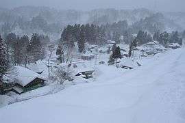
Tōkamachi has a Humid climate (Köppen Cfa) characterized by warm, wet summers and cold winters with heavy snowfall. The average annual temperature in Tōkamachi is 12.5 °C. The average annual rainfall is 2077 mm with September as the wettest month.The temperatures are highest on average in August, at around 25.6 °C, and lowest in January, at around 0.4 °C.[4] Because Tōkamachi lies in a valley, wind patterns bring in clouds from both the Sea of Japan as well as the Pacific Ocean. The mountains surrounding the city (though not terribly high in altitude) act as any other mountains that affect rain and snow patterns providing a barrier for cloud patterns. This causes a great deal of the built up precipitation to drop on the city. The Tōkamachi area receives the most snow of any area on the main island of Honshu.
| Climate data for Tokamachi, Niigata (1981-2010) | |||||||||||||
|---|---|---|---|---|---|---|---|---|---|---|---|---|---|
| Month | Jan | Feb | Mar | Apr | May | Jun | Jul | Aug | Sep | Oct | Nov | Dec | Year |
| Average high °C (°F) | 3.0 (37.4) |
3.7 (38.7) |
7.4 (45.3) |
15.3 (59.5) |
21.8 (71.2) |
25.2 (77.4) |
28.4 (83.1) |
30.4 (86.7) |
25.6 (78.1) |
19.5 (67.1) |
13.1 (55.6) |
6.5 (43.7) |
16.7 (62) |
| Daily mean °C (°F) | −0.2 (31.6) |
0.0 (32) |
2.7 (36.9) |
9.0 (48.2) |
15.5 (59.9) |
19.9 (67.8) |
23.5 (74.3) |
24.9 (76.8) |
20.5 (68.9) |
14.1 (57.4) |
8.0 (46.4) |
2.6 (36.7) |
11.7 (53.1) |
| Average low °C (°F) | −3.0 (26.6) |
−3.4 (25.9) |
−1.2 (29.8) |
3.6 (38.5) |
10.0 (50) |
15.6 (60.1) |
19.8 (67.6) |
20.9 (69.6) |
16.6 (61.9) |
9.8 (49.6) |
3.9 (39) |
−0.4 (31.3) |
7.7 (45.8) |
| Average precipitation mm (inches) | 415.2 (16.346) |
268.4 (10.567) |
179.4 (7.063) |
102.1 (4.02) |
106.3 (4.185) |
141.2 (5.559) |
209.9 (8.264) |
156.1 (6.146) |
171.5 (6.752) |
164.9 (6.492) |
231.9 (9.13) |
349.1 (13.744) |
2,496 (98.268) |
| Average snowfall cm (inches) | 417 (164.2) |
308 (121.3) |
175 (68.9) |
39 (15.4) |
1 (0.4) |
0 (0) |
0 (0) |
0 (0) |
0 (0) |
0 (0) |
12 (4.7) |
212 (83.5) |
1,164 (458.4) |
| Mean monthly sunshine hours | 55.9 | 79.4 | 111.6 | 166.5 | 192.4 | 150.7 | 153.4 | 192.5 | 125.7 | 125.8 | 98.7 | 71.3 | 1,523.9 |
| Source: Japan Meteorological Agency | |||||||||||||
Demographics
Per Japanese census data,[5] the population of Tōkamachi has declined steadily over the past 40 years.
| Census Year | Population |
|---|---|
| 1970 | 85,365 |
| 1980 | 78,791 |
| 1990 | 70,938 |
| 2000 | 65,033 |
| 2010 | 58,911 |
History
The area of present-day Tōkamachi was part of ancient Echigo Province, and was part of the tenryō territories held directly by then Tokugawa shogunate. Following the Meiji restoration, was the capital of the newly-formed Nakauonuma District of Niigata Prefecture, and was proclaimed a village on April 1, 1889 with the creation of the modern municipalities system. It was raised to town status on September 24, 1897. Tōkamachi gained city status on March 31, 1954, by merging with the neighbouring villages of Nakajō, Kawaji and Rokka. The village of Yoshida (from Nakauonuma District) was annexed on December 1, 1954 followed by the village of Shimojō (from Nakauonuma District) on February 1, 1955. On April 1, 1962 - Tōkamachi absorbed the village of Mizusawa (from Nakauonuma District). The Chūetsu earthquake of October 23, 2004 caused only minor damage to the city. On April 1, 2005 Tōkamachi absorbed the towns of Matsudai and Matsunoyama (both from Higashikubiki District); the town of Kawanishi, and the village of Nakasato (both from Nakauonuma District) to create the new and expanded city of Tōkamachi.
Government
Tōkamachi has a mayor-council form of government with a directly elected mayor and a unicameral city legislature of 24 members. [6]The city contributes two members to the Niigata Prefectural Assembly. In terms of national politics, the city is part of Niigata District No.6 of the lower house of the National Diet of Japan.
Economy
Sericulture and the production of silk is a traditional mainstay of the local economy. Agriculture, notably the production of Koshihikari rice is also very important.
Education
Tōkamachi has 18 public elementary schools and nine public middle schools operated by the city government and one private elementary and one private middle school. There are four public high schools operated by the Niigata Prefectural Board of Education. The prefectural also operates three special education schools.
Transportation
Railway
![]()
- Echigo-Tazawa - Echigo-Mizusawa - Doichi - Tōkamachi - Uonuma-Nakajō - Gejō
Highway
Sister cities
International

Inside Japan
- Sapporo, Hokkaido
- Yokohama, Kanagawa
- Shibushi, Kagoshima
- Wako, Saitama
- (All signed on August 27, 2004)
Local attractions

- Tōkamachi is home to the Tōkamachi Snow Festival, which takes place every February.
- Tōkamachi also hosts the Echigo-Tsumari Art Triennial
References
- ↑ 市長プロフィール [Mayor's profile] (in Japanese). City of Tokamachi. Retrieved 2014-03-25.
- ↑ Tōkamachi city official statistics(in Japanese)
- ↑ 市長への便り(平成25年7月) [Mayor answers questions related to name of city] (in Japanese). City of Tokamachi. Archived from the original on 2014-03-25. Retrieved 2014-03-25.
- ↑ Tōkamachi climate data
- ↑ Tōkamachi population statistics
- ↑ Tōkamachi city council official home page(in Japanese)
External links
| Wikimedia Commons has media related to Tokamachi, Niigata. |
| Wikivoyage has a travel guide for Tokamachi. |
- Official website (in Japanese)
| Wards of Niigata | ||
|---|---|---|
| Special cities | ||
| Cities | ||
| Districts | ||