Goulburn, New South Wales
| Goulburn New South Wales | |||||||||||||||
|---|---|---|---|---|---|---|---|---|---|---|---|---|---|---|---|
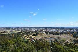 Goulburn seen from Rocky Hill | |||||||||||||||
|
Goulburn | |||||||||||||||
| Coordinates | 34°45′17″S 149°37′7″E / 34.75472°S 149.61861°ECoordinates: 34°45′17″S 149°37′7″E / 34.75472°S 149.61861°E | ||||||||||||||
| Population | 22,890 (2016 census)[1] | ||||||||||||||
| Established | 1833 | ||||||||||||||
| Postcode(s) | 2580 | ||||||||||||||
| Elevation | 702 m (2,303 ft) | ||||||||||||||
| Location | |||||||||||||||
| LGA(s) | Goulburn Mulwaree Council | ||||||||||||||
| County | Argyle | ||||||||||||||
| Parish | Goulburn | ||||||||||||||
| State electorate(s) | Goulburn | ||||||||||||||
| Federal Division(s) | Hume | ||||||||||||||
| |||||||||||||||
| |||||||||||||||
Goulburn /ˈɡoʊlbərn/ is a regional city in the Southern Tablelands of New South Wales, Australia approximately 195 kilometres (121 mi) south-west of Sydney, Australia, and 90 kilometres (56 mi) north-east of Canberra. It was proclaimed as Australia's first inland city through letters patent by Queen Victoria in 1863. Goulburn had a population of 22,890 at the 2016 census.[1] Goulburn is the seat of Goulburn Mulwaree Council.
Goulburn is a railhead on the Main Southern line, a service centre for the surrounding pastoral industry, and also stopover for those travelling on the Hume Highway. It has a central park and many historic buildings. It is also home to the monument the Big Merino, a sculpture that is the world's largest concrete constructed sheep.
History
Goulburn was named by surveyor James Meehan after Henry Goulburn, Under-Secretary for War and the Colonies, and the name was ratified by Governor Lachlan Macquarie. The Mulwaree People are the original people of the land they belonged to the Ngunawal and Gandangara language groups,[2] a Murring/Wiradjuri word indicating a special Indigenous cultural area.
The colonial government made land grants to free settlers such as Hamilton Hume in the Goulburn area from the opening of the area to settlement in about 1820. Land was later sold to settlers within the Nineteen Counties, including Argyle County (the Goulburn area). The process displaced the local indigenous Mulwaree population and the introduction of exotic livestock drove out a large part of the Aboriginal peoples' food supply.[3]
The Mulwaree People lived throughout the area covering Goulburn, Crookwell and Yass.[1] and belong to the Ngunawal language group. To the north of Goulburn Gundungurra was spoken within the lands of the Dharawal People. This was due to Gundungurra people of the Blue Mountains being driven south from their traditional land due to Governor Macquarie's parties sent to massacre the Dharawal[4] and Gundungurra[5] People.
Their neighbours were the Dharawal to their north and Dharug surrounding Sydney,[5] Darkinung, Wiradjuri Ngunawal and Thurrawal, (eastwards)[5] peoples.[4] The reduction of the food supply and the introduction of exotic diseases, substantially reduced the local indigenous population. Some local Aborigines survived at the Tawonga Billabong Aboriginal Settlement established under the supervision of the Tarago police. In the 1930s the local billabong dried up and the Aboriginal people moved away although some have, over time, made their way back to their traditional lands.
The first recorded settler in Goulburn established 'Strathallan' in 1825 (on the site of the present Police Academy) and a town was originally surveyed in 1828, although moved to the present site of the city in 1833 when the surveyor Robert Hoddle laid it out. [6]
George Johnson purchased the first land in the area between 1839 and 1842 and became a central figure in the town's development. He established a branch store with a liquor licence in 1848. By 1841 Goulburn had a population of some 1,200 – a courthouse, police barracks, churches, hospital and post office and was the centre of a great sheep and farming area.
A telegraph station opened in 1862, by which time there were about 1,500 residents, a blacksmith's shop, two hotels, two stores, the telegraph office and a few cottages. The town was a change station (where coach horses were changed) for Cobb & Co by 1855. A police station opened the following year and a school in 1858. Goulburn was proclaimed a municipal government in 1859 and was made a city in 1863.[7]
Goulburn holds the unique distinction of being proclaimed a City on two occasions. The first, unofficial, proclamation was claimed by virtue of Royal Letters Patent issued by Queen Victoria on 14 March 1863 to establish the Diocese of Goulburn. It was a claim made for ecclesiastical purposes, as it was required by the traditions of the Church of England. The Letters Patent also established St Saviour's Church as the Cathedral Church of the diocese. This was the last instance in which Letters Patent were used in this manner in the British Empire, as they had been significantly discredited for use in the colonies, and were soon to be declared formally invalid and unenforceable in this context.[8] Several legal cases[9] over the preceding decade in particular had already established that the monarch had no ecclesiastical jurisdiction in colonies possessing responsible government. This had been granted to NSW in 1856, seven years earlier. The Letters Patent held authority only over those who submitted to it voluntarily, and then only within the context of the Church – it had no legal civil authority or implications. An absolute and retrospective declaration to this effect was made in 1865 in the Colenso Case,[8] by the Judiciary Committee of the Privy Council. However, under the authority of the Crown Lands Act 1884[10] (48. Vict. No. 18), Goulburn was officially proclaimed a City on 20 March 1885[11] removing any lingering doubts as to its status. This often unrecognised controversy has in no way hindered the development of Goulburn as a regional centre, with an impressive court house (completed in 1887) and other public buildings, as a centre for wool selling, and as an industrial town.

The arrival of the railway in 1869, which was opened on 27 May by the Governor Lord Belmore (an event commemorated by Belmore Park in the centre of the city), along with the completion of the line from Sydney to Albury in 1883, was a boon to the city.[12] Later branchlines were constructed to Cooma (opened in 1889) and later extended further to Nimmitabel and then to Bombala, and to Crookwell and Taralga. Goulburn became a major railway centre with a roundhouse[13] and engine servicing facilities and a factory which made pre-fabricated concrete components for signal boxes and station buildings. The roundhouse is now the Goulburn Rail Heritage Centre with steam, diesel and rolling stock exhibits. CFCL Australia operate the Goulburn Railway Workshops.
St Saviour's Cathedral, designed by Edmund Thomas Blacket, was completed in 1884 with the tower being added in 1988 to commemorate the Bicentenary of Australia. Though completed in 1884, some earlier burials are in the graveyard adjacent to the Cathedral. St Saviour's is the seat of the Bishop of Canberra and Goulburn. The Church of SS Peter and Paul is the former cathedral for the Roman Catholic Archdiocese of Canberra and Goulburn.
The Goulburn Viaduct was built in 1915 replacing an earlier structure. This brick arch railway viaduct spanning the Mulwaree Ponds is the longest on the Main Southern railway line and consists of 13 arches each spanning 13.1 m (43 ft).[14]
In 1962, Goulburn was the focus of the fight for state aid to non-government schools. An education strike was called in response to a demand for installation of three extra toilets at a local Catholic primary school, St Brigid's. The local Catholic archdiocese closed down all local Catholic primary schools and sent the children to the government schools. The Catholic authorities declared that they had no money to install the extra toilets. Nearly 1,000 children turned up to be enrolled locally and the state schools were unable to accommodate them. The strike lasted only a week but generated national debate. In 1963 the prime minister, Robert Menzies, made state aid for science blocks part of his party's platform.[15]
Heritage listings
Goulburn has a number of heritage-listed sites, including:
|
|
Geography
Goulburn is located a small distance east of the peak ridge of the Great Dividing Range and is 690 metres (2,264 ft) above sea-level. It is intersected by the Wollondilly River and the Mulwaree River, and the confluence of these two rivers is also located here. The Wollondilly then flows north east, into Lake Burragorang (Warragamba Dam) and eventually into the Tasman Sea via the Hawkesbury River.
Climate
Owing to its elevation, Goulburn has a subtropical highland climate (Cfb) with warm summers and cold winters, and a high diurnal temperature variation. Its climate is variable, though generally dry with maximum temperatures averaging from 11.6 °C (52.9 °F) in July to 27.8 °C (82.0 °F) in January. Rainfall is distributed evenly throughout the year, with an annual average of 536.2 mm (21.1 in). Temperature extremes have ranged from −10.9 to 40.4 °C (12.4 to 104.7 °F).
| Climate data for Goulburn Airport (1988–2017) | |||||||||||||
|---|---|---|---|---|---|---|---|---|---|---|---|---|---|
| Month | Jan | Feb | Mar | Apr | May | Jun | Jul | Aug | Sep | Oct | Nov | Dec | Year |
| Record high °C (°F) | 40.4 (104.7) |
40.7 (105.3) |
35.9 (96.6) |
30.7 (87.3) |
24.4 (75.9) |
20.7 (69.3) |
19.4 (66.9) |
24.1 (75.4) |
30.5 (86.9) |
31.3 (88.3) |
39.9 (103.8) |
38.6 (101.5) |
40.7 (105.3) |
| Average high °C (°F) | 27.9 (82.2) |
26.4 (79.5) |
23.8 (74.8) |
19.9 (67.8) |
15.9 (60.6) |
12.4 (54.3) |
11.7 (53.1) |
13.4 (56.1) |
16.5 (61.7) |
19.8 (67.6) |
23.0 (73.4) |
25.8 (78.4) |
19.7 (67.5) |
| Average low °C (°F) | 12.7 (54.9) |
12.7 (54.9) |
10.1 (50.2) |
5.7 (42.3) |
2.5 (36.5) |
1.3 (34.3) |
0.3 (32.5) |
0.5 (32.9) |
3.1 (37.6) |
5.1 (41.2) |
8.3 (46.9) |
10.7 (51.3) |
6.1 (43) |
| Record low °C (°F) | −0.1 (31.8) |
0.7 (33.3) |
−0.1 (31.8) |
−6.3 (20.7) |
−8.1 (17.4) |
−10.2 (13.6) |
−10.4 (13.3) |
−10.9 (12.4) |
−7.4 (18.7) |
−5.6 (21.9) |
−4.4 (24.1) |
−1.2 (29.8) |
−10.9 (12.4) |
| Average rainfall mm (inches) | 48.9 (1.925) |
52.7 (2.075) |
40.0 (1.575) |
25.6 (1.008) |
32.8 (1.291) |
60.9 (2.398) |
33.5 (1.319) |
39.9 (1.571) |
45.8 (1.803) |
50.2 (1.976) |
54.9 (2.161) |
57.6 (2.268) |
549.1 (21.618) |
| Average rainy days (≥ 0.2mm) | 7.5 | 8.6 | 9.7 | 9.3 | 11.4 | 14.5 | 14.2 | 11.5 | 11.5 | 9.4 | 9.5 | 8.3 | 125.4 |
| Average relative humidity (%) | 41 | 45 | 46 | 46 | 54 | 63 | 61 | 52 | 50 | 46 | 45 | 39 | 49 |
| Source: Bureau of Meteorology[35] | |||||||||||||
Water supply
With a history of water shortages, an 84 km underground water supply pipeline was constructed to pump water from the Wingecarribee Reservoir in the Southern Highlands to Goulburn. This pipeline has a capacity of 7.5 ML per day.[36]
The $54 million water supply pipeline is largest construction project in the history of Goulburn.[37]
Landmarks
As a major settlement of southern New South Wales, Goulburn was the administrative centre for the region and was the location for important buildings of the district. The first lock-up in the town was built in 1830.[38] In 1832 a postal service commenced in Goulburn, four years after the service was adopted in New South Wales. The first town plan had been drawn up by Assistant Surveyor Dixon in 1828, but the site was moved, as it was subject to flooding. The new town plan was drawn up by Surveyor Hoddle and was gazetted in 1833.[7]
Gallery
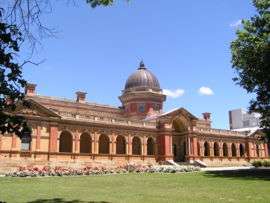
Goulburn's second court house was built in 1847; designed by Mortimer Lewis, the colonial architect.[39] James Barnet, the colonial architect from 1862-90, built a number of buildings in Goulburn. These included the Goulburn Gaol that opened 1884; the current court house that opened in 1887; and a post office in 1881. Barnet's successor, Walter Liberty Vernon, was responsible for the first buildings of Kenmore Hospital, completed in 1894. St Saviour's Anglican Cathedral and Hall were designed by Edmund Blacket. Building started in 1874 and it was dedicated in 1884. It was finally consecrated in 1916. A tower was added in 1988 as part of a Bicentennial project but Blacket's plans included a spire which is yet to be added. E.C. Manfred was a prominent local architect responsible for many of the buildings in the city, including the first public swimming baths opened in 1892; the old Town Hall constructed in 1888; the Goulburn Base Hospital designed in 1886; the old Fire Station built in 1890; the Masonic Temple built in 1928; he also designed the earlier building of 1890 it replaced. Goulburn's first permanent fire station built 1890 and designed by local architect E.C. Manfred. The city was home to Kenmore Hospital, a psychiatric hospital which was finally closed in 2003.[40] Goulburn remains a hub for mental health with facilities now located at the Goulburn Base Hospital.
 The court house, completed in the Victorian Free Classical style designed by Barnet; opened 1887.[39]
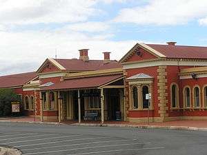 Railway station; completed in 1869.
 Goulburn Correctional Centre – main buildings designed by Barnet in 1884.
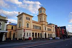 Goulburn Post Office designed by Barnet in 1880-81.
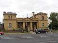 Former police station on Sloane Street, designed by Barnet and opened in 1885.
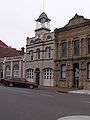 Fire station, completed in 1890.
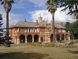 Kenmore Hospital, main buildings designed by Walter Liberty Vernon, completed 1894.
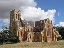 St Saviour's Cathedral, designed by Blacket; building commenced in 1874.
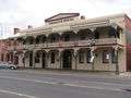 The Coolavin Hotel in Sloane Street; the hotel was built in 1850 but the present facade dates from the 1880s.
 Goulburn brewery.
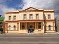 Masonic Temple built in 1928 by local architect E.C. Manfred . It replaced an earlier building from 1890, also designed by Manfred.
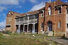 St. John's Orphanage built in 1912 and designed by Manfred.
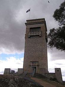 Rocky Hill War Memorial tower opened 1925.
 Elmslea Chambers, built in 1933 for a wealthy pastoralist, in the art deco style.
New South Wales Police Academy
The Police Academy relocated to Goulburn from Sydney in 1984. At this time it was known as the New South Wales Police Academy however the name has subsequently changed.
The Academy has relocated to the former campus of the Goulburn College of Advanced Education located on the banks of the Wollondilly River. The New South Wales Police Academy is now the largest education institution for law enforcement officers in the southern hemisphere.
Since its relocation there has been significant expansion of the facilities including a new site on the Taralga Road which houses the New South Wales Police School of Traffic and Mobile Policing.
Goulburn Medical Clinic

The Goulburn Medical Clinic was established in 1946 making it the most longstanding medical practice in the city. Historically, it was the first group practice of any size established in New South Wales and probably only the third in Australia.[41] The clinic has a mixture of general practitioners and specialists that provide comprehensive healthcare.[41]
Goulburn Gaol
Goulburn is home to Goulburn Correctional Centre, more generically known as Goulburn Gaol. It is a maximum-security male prison, the highest security prison in Australia and is home to some of the most dangerous, and infamous, prisoners.[42]
Goulburn Rail Heritage Centre
The roundhouse at Goulburn was a significant locomotive depot both in the steam and early diesel eras. After closure it became the Goulburn Rail Heritage Centre, a railway museum with preserved steam and diesel locomotives as well as many interesting examples of rolling stock. Some minor rail operators such as RailPower have used the site to restore diesel locomotives to working order for main line use.
Theatre scene
Goulburn is home to Australia's oldest existing theatre company Lieder Theatre Company, established in 1891. The Lieder Theatre Company presents up to five major performance projects each year, along with numerous community events, readings, workshops, and short seasons of experimental and new work. The company, along with the Lieder Youth Theatre Company, is based in the historic Lieder Theatre, built by the company in 1929.[43]
Governance
Goulburn is the seat of the Goulburn Mulwaree Shire local government area (LGA) of New South Wales, Australia, formed in 2004. The most recent elections for Council were held on 13 September 2008. Two of the elected Councillors, Max Hadlow and Keith Woodman resigned due to ill health in 2009. A by-election to fill the vacancies was held in June 2009 and resulted in the election of Councillors Geoffrey Kettle and Geoffrey Peterson. Councillor Geoffrey Kettle was elected Mayor, replacing Councillor Carol James, in September 2010.
Transport
Goulburn is approximately two hours drive from Sydney via the Hume Highway, or a one-hour drive from Canberra via the Federal and Hume Highways. Goulburn was bypassed in 1992 due to increasing traffic on the Hume Highway.
Goulburn railway station is the southern terminus of the Southern Highlands Line which reaches from Campbelltown and is part of the NSW TrainLink intercity passenger train system. Most services on the line terminate at Moss Vale, some 65 km northeast, meaning Goulburn sees limited passenger service. The station is also served by the long distance Southern XPT and Xplorer trains between Sydey and Griffith, Canberra and Southern Cross railway station in Melbourne. All services are operated by NSW TrainLink.
Goulburn Airport is approximately 7 km (4.3 mi) south of Goulburn and services light aircraft.
Public transport within Goulburn consists of the local taxi and bus service operated by PBC Goulburn.
Goulburn Tourist Information Centre has a Tesla Motors Supercharger station.[44]
Media
Radio stations
Radio stations with transmitters located in or nearby to Goulburn include-
AM:
- Radio National (2RN) 1098 AM
- 2GN 1368 AM (commercial)
FM:
- Raw FM 87.6 (narrowcast)
- Triple J (2JJJ) 88.7 FM
- ABC Classic FM (2ABCFM) 89.5 FM
- ABC Local Radio (2ABCRR) 90.3 FM
- Eagle FM 93.5 (2SNO) (commercial)
- SKY Sports Radio 94.3 FM (2KY) (narrowcast)
- ABC NewsRadio (2PNN) 99.9 FM
- Hot Country Radio 100.7 FM (narrowcast)
- 2GCR 103.3 FM (community)
Depending on location some Illawarra and/or Canberra based radio stations can also heard.
Television
Goulburn receives five free-to-air television networks relayed from Canberra, and broadcast from nearby Mt Gray:
A much smaller retransmission site also exists to cover residences in the suburb of Eastgrove.
Notable residents
- Todd Carney, Australian Rugby League player
- Jarrod Croker, Australian Rugby League player, captain Canberra Raiders 2015 -
- Bruce Devlin, former professional golfer who won 8 tournaments on the US PGA Tour
- Michael Diamond, Target Shooter and Olympic Gold Medalist
- Miles Franklin, writer
- William Hovell, a famous English Australian explorer is buried in one of the many cemeteries.
- George Lazenby, (born 1939), the only Australian actor to play James Bond, in On Her Majesty's Secret Service.[45][46]
- George Ogilvie, theatre director, born in Goulburn in 1931
- Simon Poidevin, Australian Rugby Union Player and World Cup Winner in 1991.
- Donald MacDonald, Australian pastoralist.
- Kate Ritchie, actress and former radio host
- Ursula Stephens, Australian ALP Senator serving 2002-2014
- Glen Turner, Australian Kookaburras hockey player
See also
References
- 1 2 Australian Bureau of Statistics (27 June 2017). "Goulburn (SA2)". 2016 Census QuickStats. Retrieved 10 July 2017.

- ↑ "Goulburn". Geographical Names Register (GNR) of NSW. Geographical Names Board of New South Wales. Retrieved 30 April 2006.
- ↑ Goulburn Heritage Study (1981) cited in "Goulburn:Aboriginal'". Archive associated with Australia Street project. University of Technology, Sydney. Archived from the original on 19 August 2006. Retrieved 2006-07-11.
- ↑ "Campbelltown's Aboriginal History" (PDF). macarthur.com.au. Campbelltown Visitor Information Centre. Retrieved 12 April 2018.
- ↑ Wrigley, John. "History of Camden". Camden History. Camden Historical Society. Retrieved 12 April 2018.
- ↑ Colville, Berres Hoddle (July 2006), "Robert Hoddle: pioneer surveyor-artist in Australia", National Library of Australia News, 16 (10): 18–21, ISSN 1035-753X
- 1 2 "Goulburn". Goulburn was declared a municipality in 1859 and was made a city in 1863. Heritage Australia Publishing. Retrieved 10 December 2013.
- 1 2 Judiciary Committee of the Privy Council (1865-03-21). "Case of the Bishop of Natal". The Times. p. 14.
- ↑ Queen v. the Provost of the College of Eton, 1857; Ex parte, the Rev George King, 1861; Long v. the Bishop of Cape Town, 1863; re the Bishop of Natal, 1865.
- ↑ NSW Government Gazette 1884. IV. 17 October 1884. pp. 7107ff.
"ANNO QUADRAGESIMO OCTAVO VICTORIAE REGINAE". New South Wales Government Gazette (541). New South Wales, Australia. 23 October 1884. p. 7107ff – via National Library of Australia. - ↑ NSW Government Gazette 1885. I. 20 March 1885.
"CITIES, TOWNS, AND VILLAGES". New South Wales Government Gazette (122). New South Wales, Australia. 20 March 1885. p. 1931 – via National Library of Australia. - ↑ "OPENING OF THE GREAT SOUTHERN RAILWAY TO GOULBURN". The Sydney Morning Herald. National Library of Australia. 16 June 1869. p. 7. Retrieved 7 December 2013.
- ↑ McLeod, A. R. Goulburn Locomotive Depot, February 1947 Australian Railway History, December 2005 pp483-489
- ↑ "Goulburn Viaduct (Mulwaree Ponds), New South Wales State Heritage Register (NSW SHR) Number H01035". New South Wales State Heritage Register. Office of Environment and Heritage.
- ↑ "The Battle for State Aid". Timeframe. Australian Broadcasting Corporation. 1997. Archived from the original on 6 January 2014. Retrieved 2006-04-02. ; J. Warhurst, Fifty years since the “Goulburn Strike”: Catholics and education politics, Journal of the Australian Catholic Historical Society 33 (2012), 72-82.
- ↑ "Goulburn Post Office, New South Wales State Heritage Register (NSW SHR) Number H01424". New South Wales State Heritage Register. Office of Environment and Heritage. Retrieved 18 May 2018.
- ↑ "St. Saviour's Cathedral, New South Wales State Heritage Register (NSW SHR) Number H01798". New South Wales State Heritage Register. Office of Environment and Heritage. Retrieved 18 May 2018.
- ↑ "Goulburn Brewery, New South Wales State Heritage Register (NSW SHR) Number H00178". New South Wales State Heritage Register. Office of Environment and Heritage. Retrieved 18 May 2018.
- ↑ "Lansdowne, New South Wales State Heritage Register (NSW SHR) Number H00132". New South Wales State Heritage Register. Office of Environment and Heritage. Retrieved 18 May 2018.
- ↑ "CML Building, New South Wales State Heritage Register (NSW SHR) Number H00129". New South Wales State Heritage Register. Office of Environment and Heritage. Retrieved 18 May 2018.
- ↑ "Rossi Bridge over Wollondilly River, New South Wales State Heritage Register (NSW SHR) Number H01479". New South Wales State Heritage Register. Office of Environment and Heritage. Retrieved 18 May 2018.
- ↑ "Goulburn Viaduct (Mulwaree Ponds), New South Wales State Heritage Register (NSW SHR) Number H01035". New South Wales State Heritage Register. Office of Environment and Heritage. Retrieved 18 May 2018.
- ↑ "Goulburn Railway Station, yard group and movable relics, New South Wales State Heritage Register (NSW SHR) Number H01152". New South Wales State Heritage Register. Office of Environment and Heritage. Retrieved 18 May 2018.
- ↑ "Goulburn Correctional Centre complex, New South Wales State Heritage Register (NSW SHR) Number H00808". New South Wales State Heritage Register. Office of Environment and Heritage. Retrieved 18 May 2018.
- ↑ "Riversdale, New South Wales State Heritage Register (NSW SHR) Number H01504". New South Wales State Heritage Register. Office of Environment and Heritage. Retrieved 18 May 2018.
- ↑ "Goulburn Court House and Residence, New South Wales State Heritage Register (NSW SHR) Number H00793". New South Wales State Heritage Register. Office of Environment and Heritage. Retrieved 18 May 2018.
- ↑ "Connollys Mill, New South Wales State Heritage Register (NSW SHR) Number H00215". New South Wales State Heritage Register. Office of Environment and Heritage. Retrieved 18 May 2018.
- ↑ "Old Police Barracks, New South Wales State Heritage Register (NSW SHR) Number H00546". New South Wales State Heritage Register. Office of Environment and Heritage. Retrieved 18 May 2018.
- ↑ "Railway Workshops (former), New South Wales State Heritage Register (NSW SHR) Number H00601". New South Wales State Heritage Register. Office of Environment and Heritage. Retrieved 18 May 2018.
- ↑ "Alpine Lodge Hotel, New South Wales State Heritage Register (NSW SHR) Number H00483". New South Wales State Heritage Register. Office of Environment and Heritage. Retrieved 18 May 2018.
- ↑ "St. Clair, New South Wales State Heritage Register (NSW SHR) Number H00117". New South Wales State Heritage Register. Office of Environment and Heritage. Retrieved 18 May 2018.
- ↑ "Kenmore Hospital Precinct, New South Wales State Heritage Register (NSW SHR) Number H01728". New South Wales State Heritage Register. Office of Environment and Heritage. Retrieved 18 May 2018.
- ↑ "St. Peter and Paul's Former Cathedral, New South Wales State Heritage Register (NSW SHR) Number H01797". New South Wales State Heritage Register. Office of Environment and Heritage. Retrieved 18 May 2018.
- ↑ "Goulburn Pumping Station, Marsden Weir & Appleby Steam Engine, New South Wales State Heritage Register (NSW SHR) Number H00356". New South Wales State Heritage Register. Office of Environment and Heritage. Retrieved 18 May 2018.
- ↑ "GOULBURN AIRPORT AWS". Climate statistics for Australian locations. Bureau of Meteorology. January 2018. Retrieved 11 January 2018.
- ↑ "Goulburn Water Supply Pipeline". The project involved the design and construction of a pipeline and pump station from the Wingecarribee Reservoir near Moss Vale in New South Wales to the Goulburn treatment plant. The pipeline is 84 kilometres long and is capable of supplying the Goulburn community with up to 7.5 million litres of water per day. Commonwealth of Australia. Retrieved 7 December 2013.
- ↑ "June start for Goulburn pipeline". ABC news. 29 July 2009. Retrieved 7 December 2013.
- ↑ "Fast Fact: Goulburn Gaol". Tourism Business Unit of Goulburn Mulwaree Council. Retrieved 20 July 2014.
- 1 2 "Goulburn Court House and Residence". New South Wales State Heritage Register. Office of Environment and Heritage. Retrieved 17 November 2017.
- ↑ Walsh, Gerard (18 February 2013). "Last Kenmore artefact in time for 150th b'day". Goulburn Post. Retrieved 20 July 2014.
- 1 2 Coombes, B. (1996) A History of the Goulburn Medical Clinic. Australia: Argyle Press ISBN 0-646-29851-8
- ↑ Mitchell, Alex (22 April 2007). "Mastermind recruiting Islamic gang inside super jail". The Sydney Morning Herald. Retrieved 6 January 2012.
- ↑ "Lieder Theatre Company". Sydney.com.au. NSW Government. Retrieved 27 May 2018.
- ↑ "Goulburn Supercharger - Tesla Australia". www.tesla.com. Retrieved 7 April 2018.
- ↑ Gordon, Chris. "Lazenby's Goulburn bond" Goulburn Post, 3 November 2010
- ↑ Australian National Portrait Gallery. "Australians in Hollywood". National Portrait Gallery. Retrieved 2010-11-02.
External links
| Wikimedia Commons has media related to Goulburn, New South Wales. |
| Wikivoyage has a travel guide for Goulburn. |
- Goulburn Mulwaree Council
- Goulburn Visitor Information Centre
- "Goulburn". Climate Averages for Australian Sites. Bureau of Meteorology. Retrieved 2006-11-29.
- "Goulburn-Mulwaree election results" (PDF). Results of election. New South Wales Electoral Commission. Archived from the original (PDF) on 27 February 2009. Retrieved 28 September 2008.
- VisitNSW.com – Goulburn Area
| Towns | |
|---|---|
| Localities and rural places |
|
Main Article: Local government areas of New South Wales | |