Marulan
| Marulan New South Wales | |||||||||||||||
|---|---|---|---|---|---|---|---|---|---|---|---|---|---|---|---|
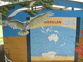 Mural at Marulan which says that it lies on the 150 meridian | |||||||||||||||
|
Marulan | |||||||||||||||
| Coordinates | 34°43′S 150°00′E / 34.717°S 150.000°ECoordinates: 34°43′S 150°00′E / 34.717°S 150.000°E | ||||||||||||||
| Population | 1,178 (2016 census)[1] | ||||||||||||||
| Established | 1868 | ||||||||||||||
| Postcode(s) | 2579 | ||||||||||||||
| Location | |||||||||||||||
| LGA(s) | Goulburn Mulwaree Council | ||||||||||||||
| County | Argyle | ||||||||||||||
| Parish | Marulan | ||||||||||||||
| State electorate(s) | Goulburn | ||||||||||||||
| Federal Division(s) | Hume | ||||||||||||||
| |||||||||||||||
Marulan is a small town in the Southern Tablelands of New South Wales, Australia in the Goulburn Mulwaree Council local government area. It is located south-west of Sydney on the Hume Highway, although it bypasses the town proper. Marulan lies on the 150th meridian east. It has a railway station on NSW TrainLink's Southern Highlands Line. Marulan was previously known as Mooroowoolen.
At the 2016 census, Marulan had a population of 1,178 people.[1]
History
In the early years of European settlement at Sydney, exploration southwest of Sydney was slow. In 1818, Hamilton Hume and James Meehan reached "the Goulburn plains" for the first time. Governor Lachlan Macquarie ordered the construction of the Great South Road (the basis of the northern end of the Hume Highway) in 1819 from Picton to the Goulburn Plains.
The southern part of Macquarie's road ran from Sutton Forest roughly along existing minor roads to Canyonleigh, Brayton, Carrick and Towrang, where it joined the current route to Goulburn. Branching from this route (now called the Illawarra Highway at this point) just south of Sutton Forest, a road, now known as Old Argyle Road, developed in the 1820s. It ran to Bungonia, via Wingello, Tallong, and the southern outskirts of Marulan, all, except Wingello, located in Argyle County,[note 1] along with Goulburn.[2] In the early 19th century Bungonia was expected to become a major centre, but it subsequently proved unsuitable for intensive agriculture.
When Thomas Mitchell rerouted the Great South Road in the 1830s, he decided to bring these two roads together and build a junction at old Marulan, with roads proceeding to Goulburn and Bungonia.[2] When the Main Southern railway reached Marulan in 1868, the town migrated 3 km north to the railway station. Nevertheless, the old cemetery remains at the Bungonia Road intersection. A quarry is being developed near the intersection, so an interchange has been built there.
Heritage listings
Marulan has a number of heritage-listed sites, including:
- Old Marulan Town[3]
- 16501 Hume Highway, Narambulla Creek: Wandi[4]
- Main Southern railway: Marulan railway station[5]
Notes
- ↑ Counties never became serious units of government in New South Wales, but they are still referred to in land titles.
References
| Wikimedia Commons has media related to Marulan, New South Wales. |
- 1 2 Australian Bureau of Statistics (27 June 2017). "Marulan (State Suburbs)". 2016 Census QuickStats. Retrieved 10 July 2016.

- 1 2 Lay, Max (1984). History of Australian Roads. Australian Road Research Board. ISBN 0-86910-164-1.
- ↑ "Old Marulan Town, New South Wales State Heritage Register (NSW SHR) Number H00127". New South Wales State Heritage Register. Office of Environment and Heritage. Retrieved 18 May 2018.
- ↑ "The Ben Hall Sites - Wandi, New South Wales State Heritage Register (NSW SHR) Number H01827". New South Wales State Heritage Register. Office of Environment and Heritage. Retrieved 18 May 2018.
- ↑ "Marulan Railway Station and yard group, New South Wales State Heritage Register (NSW SHR) Number H01188". New South Wales State Heritage Register. Office of Environment and Heritage. Retrieved 18 May 2018.
| Towns | |
|---|---|
| Localities and rural places |
|
Main Article: Local government areas of New South Wales | |