Laggan, New South Wales
| Laggan New South Wales | |||||||||||||||
|---|---|---|---|---|---|---|---|---|---|---|---|---|---|---|---|
 | |||||||||||||||
|
Laggan | |||||||||||||||
| Coordinates | 34°25′S 149°32′E / 34.417°S 149.533°ECoordinates: 34°25′S 149°32′E / 34.417°S 149.533°E | ||||||||||||||
| Population | 358 (2016 census)[1] | ||||||||||||||
| Postcode(s) | 2583 | ||||||||||||||
| Location | |||||||||||||||
| LGA(s) | Upper Lachlan Shire | ||||||||||||||
| State electorate(s) | Goulburn | ||||||||||||||
| Federal Division(s) | Hume | ||||||||||||||
| |||||||||||||||
Laggan is a small village in the Southern Tablelands, New South Wales, Australiain Upper Lachlan Shire. At the 2016 census, Laggan had a population of 358.[1]
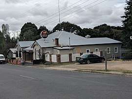
The village/locality has a small primary school, a café, as well as a pub and many historic buildings, and also is the home of the monthly Laggan Village Markets. Founded for pastoral use, as well as a stop for convicts during earlier times, the village is now a tourist attraction.[2]
References
- 1 2 Australian Bureau of Statistics (27 June 2017). "Laggan (State Suburb)". 2016 Census QuickStats. Retrieved 6 July 2017.

- ↑ Tuena and Laggan
| Towns | |
|---|---|
| Localities and rural places |
|
Main Article: Local government areas of New South Wales | |
This article is issued from
Wikipedia.
The text is licensed under Creative Commons - Attribution - Sharealike.
Additional terms may apply for the media files.