Burnie, Tasmania
| Burnie Tasmania | |||||||||
|---|---|---|---|---|---|---|---|---|---|
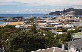 A view of Burnie CBD and port | |||||||||
 Burnie | |||||||||
| Coordinates | 41°03′49″S 145°52′31″E / 41.06361°S 145.87528°ECoordinates: 41°03′49″S 145°52′31″E / 41.06361°S 145.87528°E | ||||||||
| Population | 19,385 (2016 census)[1] | ||||||||
| Time zone | AEST (UTC+10) | ||||||||
| • Summer (DST) | AEDT (UTC+11) | ||||||||
| Location |
| ||||||||
| LGA(s) | City of Burnie | ||||||||
| State electorate(s) | Montgomery, Murchision | ||||||||
| Federal Division(s) | Braddon | ||||||||
| |||||||||
Burnie is a port city on the north-west coast of Tasmania. When founded in 1827, Burnie was named Emu Bay but it was renamed for William Burnie, a director of the Van Diemen's Land Company, in the early 1840s. Burnie was proclaimed a city by Queen Elizabeth ll on April 26, 1988.
At the 2016 Australian Census Burnie had an urban population of 19,385.[1] Burnie is governed by the City of Burnie local government area.
Economy
The key industries are heavy manufacturing, forestry and farming. The Burnie port along with the forestry industry provides the main source of revenue for the city.[2][3] Burnie was the main port for the west coast mines after the opening of the Emu Bay Railway in 1897. Most industry in Burnie was based around the railway and the port that served it.
After the hand over of the Surrey Hills and Hampshire Hills lots, the agriculture industry was largely replaced by forestry. The influence of forestry had a major role on Burnie's development in the 1900s with the founding of the pulp and paper mill by Associated Pulp and Paper Mills in 1938 [4] and the woodchip terminal in the later part of the century. The Burnie Paper Mill closed in 2010 after failing to secure a buyer.[5]
Population
According to the 2016 census of Population, there were 19,385 people in Burnie - Somerset urban centre.
- Aboriginal and Torres Strait Islander people made up 7.2% of the population.
- 85.4% of people were born in Australia. The next most common countries of birth were England 2.5% and New Zealand 0.8%.
- 91.5% of people spoke only English at home.
- The most common responses for religion were No Religion 37.5%, Anglican 18.5% and Catholic 15.4%.[1]
Facilities and education
Tasmania's third largest hospital, The North West Regional Hospital is on Brickport Road. It provides both in and outpatient services for general medicine, general surgery, orthopaedics, psychiatry, and paediatrics.
Burnie has a central business district with several national retailers. Just outside the CBD there are other major retailers including: Harvey Norman Superstore; Spotlight; Godfreys; SuperCheap Auto.
Other amenities include the multi-function "Burnie Arts and Function Centre" (formerly known as the Civic Centre), post office, police station, supreme court, public and private hospital, as well as numerous sporting and social organisations.
Burnie is also home to the Cradle Coast campus of the University of Tasmania, and campuses of the Tasmanian Polytechnic and the Tasmanian Academy. The University of Tasmania campus includes the Cuthbertson Research Laboratores run by the Tasmanian Institute of Agricultural Research.
Transport
Burnie Airport is located in the adjacent town of Wynyard, a 20-minute drive from the City of Burnie.
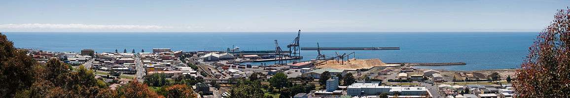
Burnie Port is Tasmania's largest general cargo port[6] and was once Australia's fifth largest container port. It is the nearest Tasmanian port to Melbourne and the Australian mainland. As with other ports in Tasmania, it is operated by the government owned TasPorts.[7]
The port currently operates as a container port with a separate terminal for the exportation of woodchips. The port was planned to be expanded in 2013 so that it could accommodate extra freight from the proposed north-west mines in the Tarkine.[8]
Burnie is connected with Devonport via the four lane Bass Highway and a rail link which is used for freight purposes. Burnie is also connected to the west coast of Tasmania by the Murchison Highway.
Bus service Metro Tasmania provides transport around the city and its suburbs.,[9] Redline Coaches provides daily coach services to several towns and to the city of Hobart.[10]
Suburbs
Climate
Burnie has an oceanic climate with mild summers and cool winters. The average temperature in summer ranges from 12 to 21 °C with drier days as warm as 30 °C, with around 16 hours of sunlight per day. In winter, temperature ranges from 6 to 13 °C, and only 8 hours of sunlight. Relative humidity averages over 60% for the year in the afternoon.
Burnie averages 994 mm of rainfall per year. Most of the rain is during the cooler months from May to October. The summer months bring constant daily sunshine and only occasional rainfall with temperatures up to 30 °C on the warmest and driest days. Nearly every day from January to March has a maximum temperature of 20–25 °C.
| Climate data for Round Hill, Burnie (1981–2010 normals; extremes since 1944) | |||||||||||||
|---|---|---|---|---|---|---|---|---|---|---|---|---|---|
| Month | Jan | Feb | Mar | Apr | May | Jun | Jul | Aug | Sep | Oct | Nov | Dec | Year |
| Record high °C (°F) | 33.8 (92.8) |
31.0 (87.8) |
28.9 (84) |
26.2 (79.2) |
24.0 (75.2) |
18.9 (66) |
18.3 (64.9) |
18.9 (66) |
22.4 (72.3) |
27.6 (81.7) |
31.5 (88.7) |
31.2 (88.2) |
33.8 (92.8) |
| Average high °C (°F) | 21.2 (70.2) |
21.5 (70.7) |
20.3 (68.5) |
18.0 (64.4) |
15.6 (60.1) |
13.7 (56.7) |
13.0 (55.4) |
13.4 (56.1) |
14.6 (58.3) |
16.1 (61) |
18.1 (64.6) |
19.6 (67.3) |
17.1 (62.8) |
| Average low °C (°F) | 13.3 (55.9) |
13.8 (56.8) |
12.5 (54.5) |
10.8 (51.4) |
9.1 (48.4) |
7.3 (45.1) |
6.6 (43.9) |
6.7 (44.1) |
7.4 (45.3) |
8.5 (47.3) |
10.3 (50.5) |
11.7 (53.1) |
9.8 (49.6) |
| Record low °C (°F) | 2.8 (37) |
3.9 (39) |
3.5 (38.3) |
0.5 (32.9) |
0.0 (32) |
−1.1 (30) |
−1.7 (28.9) |
−2.0 (28.4) |
0.0 (32) |
−0.8 (30.6) |
1.0 (33.8) |
2.9 (37.2) |
−2.0 (28.4) |
| Average precipitation mm (inches) | 43.0 (1.693) |
33.9 (1.335) |
42.7 (1.681) |
67.7 (2.665) |
80.3 (3.161) |
97.0 (3.819) |
104.5 (4.114) |
104.0 (4.094) |
92.5 (3.642) |
74.0 (2.913) |
63.0 (2.48) |
62.1 (2.445) |
864.7 (34.043) |
| Average rainy days (≥ 0.2 mm) | 9.9 | 7.1 | 9.0 | 11.0 | 13.8 | 15.0 | 17.1 | 17.4 | 16.5 | 14.6 | 11.9 | 10.3 | 153.6 |
| Mean daily sunshine hours | 8.2 | 7.7 | 6.2 | 5.3 | 4.1 | 4.0 | 4.1 | 4.5 | 5.3 | 6.8 | 7.3 | 7.5 | 5.9 |
| Source #1: Bureau of Meteorology[11][12] | |||||||||||||
| Source #2: Bureau of Meteorology (1965–1993 sunshine hours)[13] | |||||||||||||
Sport
Australian rules football is popular in Burnie. The city's team was the Burnie Dockers Football Club in the Tasmanian State League. Their ground was West Park Oval.
Rugby union is also played in Burnie. The local club is the Burnie Rugby Union Club. They are the current Tasmanian Rugby Union Statewide Division Two Premiers and were promoted to the Statewide First Division for the 2008 season. Their nickname is "The Mighty Emus". The club has been in existence since 1953 but at the end of the 1980s, were forced into a temporary absence from all competitions and relinquishing their place in the statewide First Division. Their home ground is Upper Burnie Sports centre. Gerry Horch is a past player, past president, life member, and local identity.
Soccer is also represented on the north coast with Burnie United FC having four teams compete in the northern premier league, the women's team, under 18 team, reserve team and division one team. recently last year they have entered two youth side in the under 16 and under 14 northern league.
Burnie hosts an ATP Challenger Tour tennis event, the Burnie International, during the week following the Australian Open.
Athletics events include the annual Burnie Gift and Burnie Ten.
Media
The Advocate newspaper was established in 1890 servicing the North West region. The mailroom is located in Burnie whilst the local press operations ceased in mid-2008 and were relocated to Launceston..
Burnie has access to the ABC, SBS, WIN and Southern Cross television stations. The fifth channel, Tasmanian Digital Television, has recently started transmitting from the tower at Round Hill, east of the suburb of South Burnie.
There are two commercial radio stations, 7BU at 558 kHz on the AM band and Sea FM on 101.7 on the FM band. Many Melbourne radio stations can be received in Burnie.
Notable people
- Cameron Baird – Australian soldier, posthumously awarded the VC for actions in Afghanistan
- Alpha Wolf – Australian nu metalcore band
- Justin Heazlewood – Australian songwriter, author, actor and humourist also known as The Bedroom Philosopher
- Josh Earl – Comedian and former host of Spicks and Specks
- Eddie Jones – Current head coach of the English rugby union football team
- Vicki O'Halloran – Administrator of the Northern Territory
- David Guest – Australian field hockey player. 2008 Olympic bronze medalist
- Brendon Gale – AFL player Richmond Football Club
- Maverick Weller– AFL player-Gold Coast Suns and St Kilda Football Club
- Lachie Weller – AFL player-Fremantle Football Club and Gold Coast Suns
- Eli Templeton – AFL player-St Kilda Football Club
References
- 1 2 3 Australian Bureau of Statistics (27 June 2017). "Burnie-Somerset (Urban Centre)". 2016 Census QuickStats. Retrieved 28 September 2017.


- ↑ Burnie Port Authority (1986), Port of Burnie, Tasmania : port information, Burnie Port Authority, ISBN 978-0-7246-1452-3
- ↑ "Archived copy". Archived from the original on 10 April 2013. Retrieved 7 April 2013.
- ↑ "Burnie Paper Mill Nearing Completion". The Advocate. Burnie, Tas.: National Library of Australia. 4 December 1937. p. 7. Retrieved 7 April 2013.
- ↑ "Burnie paper mill to shut", Australasian Business Intelligence, COMTEX News Network, Inc, 2010-04-13, ISSN 1320-6680
- ↑ "Tasports". Archived from the original on 20 June 2015.
- ↑ Sean Ford (23 December 2013). "Single port body failed: Chamber". The Advocate. Archived from the original on 24 December 2013.
- ↑ "Burnie port upgrade". The West Australian. 15 February 2013. Archived from the original on 12 April 2013. Retrieved 16 March 2013.
- ↑ Metro Tasmania website Archived 2 January 2007 at the Wayback Machine.
- ↑ "Redline". www.redlinecoaches.com.au. Archived from the original on 12 March 2018. Retrieved 7 May 2018.
- ↑ "Climate statistics for Round Hill, Burnie". bom.gov.au. Bureau of Meteorology. Retrieved 28 October 2017.
- ↑ "Climate statistics for Round Hill, Burnie". bom.gov.au. Bureau of Meteorology. Archived from the original on 17 December 2012. Retrieved 16 July 2017.
- ↑ "Climate statistics for Elliott Research Station". bom.gov.au. Bureau of Meteorology. Archived from the original on 7 May 2018. Retrieved 16 July 2017.
External links
| Wikimedia Commons has media related to Burnie, Tasmania. |
- Burnie City Council
- Watch historical footage of Burnie, Hobart, Launceston and the rest of Tasmania from the National Film and Sound Archive of Australia's collection.
| City of Burnie |
|
|---|---|
| General |
| |
|---|---|---|
| Regions |
| |
| Cities | ||
Tasmania portal | ||