Cooma
| Cooma New South Wales | |||||||||||||||
|---|---|---|---|---|---|---|---|---|---|---|---|---|---|---|---|
 Cooma Court House | |||||||||||||||
|
Cooma | |||||||||||||||
| Coordinates | 36°14′06″S 149°07′33″E / 36.23500°S 149.12583°ECoordinates: 36°14′06″S 149°07′33″E / 36.23500°S 149.12583°E | ||||||||||||||
| Population | 6,742 (2016 census)[1] | ||||||||||||||
| Established | 1849 | ||||||||||||||
| Postcode(s) | 2630 | ||||||||||||||
| Elevation | 800 m (2,625 ft) | ||||||||||||||
| Location | |||||||||||||||
| LGA(s) | Snowy Monaro Regional Council | ||||||||||||||
| County | Beresford | ||||||||||||||
| State electorate(s) | Monaro | ||||||||||||||
| Federal Division(s) | Eden-Monaro | ||||||||||||||
| |||||||||||||||
| |||||||||||||||
Cooma is a town in the south of New South Wales, Australia. It is located 114 kilometres (71 mi) south of the national capital, Canberra, via the Monaro Highway. It is also on the Snowy Mountains Highway, connecting Bega with the Riverina.
At the 2016 census, Cooma had a population of 6,742.[1] Cooma is the main town of the Monaro region. It is 800 metres (2,620 ft) above sea level. The name could have derived from an Aboriginal word Coombah, meaning 'big lake' or 'open country'.[2]
Cooma was explored by Captain J. M. Currie in 1823. It was first surveyed in 1840, and was gazetted in 1849.[3] Cooma was proclaimed a municipality in 1879. Cooma is 5 kilometres (3 mi) south of the banks of the Murrumbidgee River, a main tributary of the Murray–Darling basin. Cooma sources its water from the river.
History
The railway from Sydney was extended from Royalla to Cooma in 1889 under the supervision of John Whitton.[4] The line was closed to rail passenger traffic in 1989.[5][6] The estimated population of Cooma was 47 in 1851 and it grew to 2330 (1911), 1969 (1933), 2249 (1947), 9103 (1966), 7353 (1976) and 7978 (1981).[7][8][9][10][11]
In 1949, the town became the headquarters of the Snowy Mountains Scheme and grew rapidly. Those working on the Snowy Scheme depended on the railway and during construction of the scheme, the railways were one of the largest employers in the region.[4] In 1959 the tenth anniversary of the scheme was celebrated with the erection of an avenue of flags representing the 27 nationalities of people working on the scheme.
Cooma has developed a growing tourism industry as it became the main rest stop for many travellers heading to the NSW snow fields during the winter months. As a result, the town nicknamed itself the 'Gateway to the Snowy Mountains'.
The Aviation Pioneers' Memorial at Cooma contains artifacts recovered from the Avro 618 Ten aircraft Southern Cloud, which crashed on 21 March 1931 in the Toolong range of the Australian Alps. The wreck was not found until 26 October 1958.[12]
Heritage listings
Cooma has a number of heritage-listed sites, including:
- Bradley Street: Cooma railway station[13]
- 59 - 61 Lambie Street: Royal Hotel[14]
- Sharp Street: Rock Bolting Development Site[15]
Education
Government schools include Monaro High School, a high school that serves the town and seven of the neighboring rural towns and villages including Peak View, Berridale, Jindabyne, Nimmitabel, Bredbo and Dalgety.[16] The other two government schools support primary education and are Cooma Public School[17] and Cooma North Public School,[18] both providing education for students in kindergarten to year 6.
The Roman Catholic school is called St Patrick's Parish School and provides education from kindergarten to year 10.[19] The Snowy Mountains Christian School, an independent Christian school provides education from kindergarten to year 10.[20]
Tertiary education is provided by TAFE NSW Illawarra Institute Cooma campus.[21] Another Tertiary Education centre is the newly opened Cooma Universities Centre
Climate
Cooma has a subtropical highland (Cfb) climate, owing to its elevation and high diurnal temperature variation. Summers are warm with cool nights, and winters are chilly with freezing nighttime lows. The area is relatively dry (by south-east coastal Australia standards), as it falls in a rain shadow. Despite its dryness, it only has 90.1 clear days annually, lower than the adjacent coastal areas of Wollongong and Sydney (106 and 107 clear days, respectively).[22][23]
Strong cold fronts often push through the region in winter and snow is not uncommon in Cooma from June to August, however is generally light and rarely settles for more than 24 hours. Severe thunderstorms are semi-frequent in summer and due to the towns elevation can carry large quantities of hail.[24]
Mean daily minimum temperatures range from −2.7 °C (27.1 °F) (July) to 10.8 °C (51.4 °F) (January), with an annual mean daily minimum of 4.1 °C (39.4 °F). Mean daily maximum temperatures range from 11.4 °C (52.5 °F) (July) to 27.3 °C (81.1 °F) (January), with an annual mean daily maximum of 19.4 °C (66.9 °F).[24]
| Climate data for Cooma | |||||||||||||
|---|---|---|---|---|---|---|---|---|---|---|---|---|---|
| Month | Jan | Feb | Mar | Apr | May | Jun | Jul | Aug | Sep | Oct | Nov | Dec | Year |
| Record high °C (°F) | 39.0 (102.2) |
38.9 (102) |
35.2 (95.4) |
30.4 (86.7) |
24.2 (75.6) |
19.6 (67.3) |
20.9 (69.6) |
24.5 (76.1) |
29.4 (84.9) |
33.1 (91.6) |
36.5 (97.7) |
36.7 (98.1) |
39.0 (102.2) |
| Average high °C (°F) | 27.3 (81.1) |
26.3 (79.3) |
23.8 (74.8) |
19.5 (67.1) |
15.6 (60.1) |
11.9 (53.4) |
11.4 (52.5) |
13.3 (55.9) |
16.3 (61.3) |
19.5 (67.1) |
22.5 (72.5) |
25.1 (77.2) |
19.4 (66.9) |
| Average low °C (°F) | 10.8 (51.4) |
10.6 (51.1) |
8.2 (46.8) |
4.1 (39.4) |
0.7 (33.3) |
−1.3 (29.7) |
−2.7 (27.1) |
−1.9 (28.6) |
1.2 (34.2) |
3.8 (38.8) |
7.0 (44.6) |
9.1 (48.4) |
4.1 (39.4) |
| Record low °C (°F) | −0.2 (31.6) |
−1.0 (30.2) |
−1.9 (28.6) |
−6.5 (20.3) |
−8.6 (16.5) |
−11.5 (11.3) |
−11.4 (11.5) |
−10.5 (13.1) |
−8.6 (16.5) |
−6.8 (19.8) |
−3.9 (25) |
−3.0 (26.6) |
−11.5 (11.3) |
| Average precipitation mm (inches) | 58.3 (2.295) |
59.7 (2.35) |
57.4 (2.26) |
39.5 (1.555) |
29.6 (1.165) |
40.2 (1.583) |
28.1 (1.106) |
27.4 (1.079) |
34.9 (1.374) |
44.8 (1.764) |
64.6 (2.543) |
57.1 (2.248) |
541.6 (21.322) |
| Average precipitation days | 8.1 | 7.8 | 8.4 | 8.4 | 7.9 | 9.9 | 8.5 | 8.6 | 9.9 | 9.6 | 11.0 | 9.2 | 107.3 |
| Average afternoon relative humidity (%) | 40 | 44 | 45 | 49 | 54 | 59 | 54 | 48 | 45 | 44 | 43 | 41 | 47 |
| Source: [24] | |||||||||||||
Media
Newspapers
One newspaper operates in Cooma,The Monaro Post, which began in 2006, and is independently owned by Gail Eastaway, Tracy Frazer and Louise Platts.
Radio stations
- 2XL 918 AM (commercial)
- Snow FM 97.7 FM (commercial)
- Triple J 100.1 FM
- ABC South-East 810 AM/1602 AM
- Radio National 95.3 FM/100.9 FM
- Classic FM 99.3
- Monaro FM 90.5 (community)
- Racing Radio 96.9 FM
- Vision Radio 88.0 FM (narrowcast, relay)
Note: transmitters for 2XL and Snow FM, as well as some ABC services, are in place throughout the Snowy Mountains.
Television
Cooma receives five free-to-air television networks including all the digital free-to-air channels relayed from Canberra, broadcast from the Telstra site Radio Hill translator in Cooma Common, off Polo Flat Road.
Stations available include:[25]
Another transmitter for the Cooma and surrounding Monaro region is located at Mount Roberts approximately 30 km NNE of the town, broadcasting The Three Commercial Networks and the ABC services, but not SBS Television Services.
Transport
Cooma is serviced by Cooma - Snowy Mountains Airport which is 15 kilometres from the CBD. Cooma has a bus service connecting various areas of town three times a day run by Cooma Coaches. Snowliner Coaches also operate services. Cooma has a taxi service run by Cooma Radio Taxis.
NSW TrainLink operate road coach services from Canberra to Bombala and Eden.[26] Cooma was served by the Cooma Mail until May 1986 and the Canberra Monaro Express until September 1988.[27]
The Cooma Monaro Railway is a heritage railway using CPH railmotors built in the 1920s. Until operations were suspended in January 2014, the railway operated a weekend and public holiday service on an 18 kilometre section of the Bombala railway line north to Bunyan and Chakola.[28]
People associated with Cooma
People born in Cooma include:
- Samantha Armytage - breakfast show host
- John Bērziņš - bishop of Caracas of the Russian Orthodox Church Outside Russia; first Australian-born orthodox bishop
- Andreas Breitfuss - hospitality professional and mountain climber
- Torah Bright - Olympic snowboarder
- Jamie Burns - NSW cricketer, 1927
- Carmen Duncan - actress
- Paula Duncan - actress
- Michael Gordon - rugby league player in the National Rugby League
- A. D. Hope - poet and Essayist
- Pat Hughes DFC - Royal Australian Air Force pilot
- Keegan Joyce - actor and singer has a song called "Cooma" included in his album, Snow On Higher Ground
- Horst Kwech - Austrian born, Cooma raised, motor racing driver in the early US based Trans-Am Series
- Virginia Lette - media personality
- Steve Liebmann - journalist
- John Tierney - Senator in the Government of Australia
- John Tranter - poet
- Brett White - rugby league player in the National Rugby League
- Jack Williams - rugby league player in the Under 20s competition
- Sam Williams - rugby league player in the National Rugby League
- Charlotte Wood - writer
Gallery
 Cooma Post Office
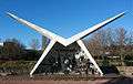 Aviation Pioneers' Memorial at Cooma
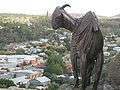 Bronze Nanny Goat, Nanny Goat Hill Lookout at Cooma
 Cooma Monaro Railway's CPH railmotor 6 at Chakola station
See also
- Cooma Correctional Centre
- Snowy Mountains Scheme
- Bombala railway line - Railway line through Cooma
References
- 1 2 Australian Bureau of Statistics (27 June 2017). "Cooma (SA2)". 2016 Census QuickStats. Retrieved 6 July 2017.

- ↑ "Cooma". Geographical Names Register (GNR) of NSW. Geographical Names Board of New South Wales. Retrieved 12 July 2009.
- ↑ "Centenary of Federation Monument". Cooma-Monaro Shire Council. 2014. Retrieved 2 March 2015.
- 1 2 "Cooma Railway Precinct". NSW Heritage Register. Office of Environment and Heritage: Government of New South Wales. 11 November 2009. Retrieved 5 April 2012.
- ↑ "Bombala Line". www.nswrail.net. Retrieved 2007-01-21.
- ↑ "Cooma Railway Station". www.nswrail.net. Retrieved 2007-01-21.
- ↑ "CENSUS OF THE COMMONWEALTH OF AUSTRALIA 1911 - Part XIV Summary" (PDF). Census of the Commonwealth of Australia 1911. Australian Bureau of Statistics. 1911. p. 211. Retrieved 18 March 2013.
- ↑ "CENSUS OF THE COMMONWEALTH OF AUSTRALIA 30th June 1933 - PART VIII. POPULATION AND OCCUPIED DWELLINGS IN LOCALITIES" (PDF). CENSUS OF THE COMMONWEALTH OF AUSTRALIA 30th June 1933. Australian Bureau of Statistics. p. 23. Retrieved 18 March 2013.
- ↑ "CENSUS OF THE COMMONWEALTH OF AUSTRALIA 30th June, 1947 - PART VIII. - POPULATION AND OCCUPIED DWELLINGS IN LOCALITIES" (PDF). CENSUS OF THE COMMONWEALTH OF AUSTRALIA 30th June, 1947. Australian Bureau of Statistics. p. 17. Retrieved 18 March 2013.
- ↑ "CENSUS OF POPULATION AND HOUSING, 30 JUNE 1966 - Vol.5, Part 1 - New South Wales" (PDF). CENSUS OF POPULATION AND HOUSING, 30 JUNE 1966 COMMONWEALTH OF AUSTRALIA. COMMONWEALTH BUREAU OF CENSUS AND STATISTICS. December 1970. p. 9. Retrieved 18 March 2013.
- ↑ "CENSUS OF POPULATION AND HOUSING, 30 JUNE 1981 PERSONS AND DWELLINGS IN LOCAL GOVERNMENT AREAS AND URBAN CENTRES - NEW SOUTH WALES" (PDF). CENSUS OF POPULATION AND HOUSING, 30 JUNE 1981. AUSTRALIAN BUREAU OF STATISTICS. 1983. p. 37. Retrieved 18 March 2013.
- ↑ "Into the Abyss & Back" (PDF). Flight Safety Magazine. FLIGHT SAFETY AUSTRALIA. July–August 2006. pp. 40–42. Retrieved 18 March 2013.
- ↑ "Cooma Railway Station and yard group, New South Wales State Heritage Register (NSW SHR) Number H01116". New South Wales State Heritage Register. Office of Environment and Heritage. Retrieved 18 May 2018.
- ↑ "Royal Hotel & Outbuildings, New South Wales State Heritage Register (NSW SHR) Number H00616". New South Wales State Heritage Register. Office of Environment and Heritage. Retrieved 18 May 2018.
- ↑ "Rock Bolting Development Site, New South Wales State Heritage Register (NSW SHR) Number H01984". New South Wales State Heritage Register. Office of Environment and Heritage. Retrieved 18 May 2018.
- ↑ "Monaro High School". NSW Government: Education and Communities. Retrieved 5 April 2012.
- ↑ "Cooma Public School". NSW Government: Education and Communities. Retrieved 5 April 2012.
- ↑ "Cooma North Public School". NSW Government: Education and Communities. Retrieved 5 April 2012.
- ↑ "St Patrick's Parish School, Cooma". Catholic Education Office Archdiocese of Canberra and Goulburn. Retrieved 5 April 2012.
- ↑ "Snowy Mountains Christian School". Snowy Mountains Christian School. Retrieved 5 April 2012.
- ↑ "Cooma Campus". TAFE NSW Illawarra Institute. Retrieved 5 April 2012.
- ↑ "Bureau of Meteorology – Summary statistics WOLLONGONG UNIVERSITY". Australian Bureau of Meteorology. Retrieved 20 November 2014.
- ↑ "Climate statistics for Australian locations". Bureau of Meteorology. Retrieved 15 November 2013.
- 1 2 3 "Climate statistics for Cooma Visitors Centre". Bureau of Meteorology. Retrieved 10 July 2018.
- ↑ "Television". Times2. The Canberra Times. 15 June 2010. p. 12.
- ↑ "Southern timetable" (PDF). NSW Trainlink. 26 November 2017.
- ↑ Banger C. The Railway Refreshment Rooms of New South Wales 1855-1995. ARHS Bulletin, Vol 54, no.790. August 2003.
- ↑ "Cooma Monaro Railway". Cooma Monaro Railway. Retrieved 5 April 2012.
External links
| Wikivoyage has a travel guide for Cooma. |
![]()
- "Climate for Cooma". Bureau of Meteorology. Australian Government. Retrieved 2009-02-24.