Coastal mountain ranges
(not part of the
Great Dividing Range) | | Mid North Coast | |
|---|
Allyn, Barrington
& Mount Royal |
- Brumlow Tops (1,586 m or 5,203 ft)
- Polblue (1,575 m or 5,167 ft)
- Barrington (1,555 m or 5,102 ft)
- Careys Peak (1,544 m or 5,066 ft)
- Eremeren Point (1,537 m or 5,043 ft)
- Royal (1,185 m or 3,888 ft)
- Allyn (1,125 m or 3,691 ft)
- Cabrebald (1,000 m or 3,281 ft)
- Ben Bullen
- Gunama
- Lumeah
|
|---|
| Gibraltar and Sugarloaf | |
|---|
| Blue Mountains |
- Coricudgy (1,255 m or 4,117 ft)
- unnamed peak (1,189 m or 3,901 ft)
- Pomany (1,109 m or 3,638 ft)
- Piddington (1,094 m or 3,589 ft)
- Boyce (1,093 m or 3,586 ft)
- York (1,061 m or 3,481 ft)
- Victoria (1,059 m or 3,474 ft)
- Banks (1,049 m or 3,442 ft)
- Tomah (1,016 m or 3,333 ft)
- Wilson (1,008 m or 3,307 ft)
- Kings Tableland (1,000 m or 3,281 ft)
- Narrow Neck Plateau (1,000 m or 3,281 ft)
- Castle Cliff (986 m or 3,235 ft)
- Solitary (950 m or 3,117 ft)
- Hay (944 m or 3,097 ft)
- Podgers (890 m or 2,920 ft)
- Irvine (850 m or 2,789 ft)
- Debert (840 m or 2,756 ft)
- Camp Cave (800 m or 2,625 ft)
- Warrigal (760 m or 2,493 ft)
- Notts (750 m or 2,461 ft)
- Harris (736 m or 2,415 ft)
- Centre (620 m or 2,034 ft)
- Hall (617 m or 2,024 ft)
- Gibson (608 m or 1,995 ft)
- Scorpion (558 m or 1,831 ft)
- Linda Rock (599 m or 1,965 ft)
- Cookem (569 m or 1,867 ft)
- Gospers
- Bedford
- Cameron
- Coriaday
- Erskine
- Mistake
- Monundilla
- Whaite
- Wirraba
- Pearces
- Wedding Cake
|
|---|
| Illawarra |
- Bells (803 m or 2,635 ft)
- Knights Hill (709 m or 2,326 ft)
- Noorinan (663 m or 2,175 ft)
- Saddleback (600 m or 1,969 ft)
- Wanyambilli Hill (564 m or 1,850 ft)
- Kembla (534 m or 1,752 ft)
- Burelli (531 m or 1,742 ft)
- Kembla West (512 m or 1,680 ft)
- Brisbane (469 m or 1,539 ft)
- Keira (464 m or 1,522 ft)
- Warra (464 m or 1,522 ft)
- Brokers Nose (440 m or 1,444 ft)
- Nebo (252 m or 827 ft)
|
|---|
| The Budawangs |
- Budawang (1,129 m or 3,704 ft)
- Currockbilly (1,087 m or 3,566 ft)
- Wog Wog (893 m or 2,930 ft)
- Cole (876 m or 2,874 ft)
- Sturgiss (858 m or 2,815 ft)
- Fosters (857 m or 2,812 ft)
- Barneys Hill (855 m or 2,805 ft)
- The Castle (831 m or 2,726 ft)
- Shrouded Gods (809 m or 2,654 ft)
- Donjon (786 m or 2,579 ft)
- Clyde (781 m or 2,562 ft)
- Quiltys (775 m or 2,543 ft)
- Wirritin (674 m or 2,211 ft)
- Pigeon House / Didthul (720 m or 2,362 ft)
- Bushwalker (640 m or 2,100 ft)
- Byangee (500 m or 1,640 ft)
- Coolangatta
- Tarn
|
|---|
|
|---|
| Great Dividing Range | | Tweed |
- Warning (1,156 m or 3,793 ft)
- Bar (1,130 m or 3,707 ft)
- Glenugie (316 m or 1,037 ft)
- Chincogan (260 m or 853 ft)
- Gladstone
- Goobergooberyam
- Moombil
|
|---|
| McPherson and Nightcap |
- Barney (1,359 m or 4,459 ft)
- Burrell 933 m or 3,061 ft)
- Neville (919 m or 3,015 ft)
- Nardi (812 m or 2,664 ft)
- Matheson (804 m or 2,638 ft)
- Peates (604 m or 1,982 ft)
|
|---|
| Mid North Coast | |
|---|
| Nandewar |
- Kaputar (1,489 m or 4,885 ft)
- Dowe (1,457 m or 4,780 ft)
- Mount Coryah (1,409 m or 4,623 ft)
- Lindesay (1,373 m or 4,505 ft)
- Grattai (1,301 m or 4,268 ft)
- Bushy (1,260 m or 4,134 ft)
- Round (1,250 m or 4,101 ft)
- Yulludunida (1,225 m or 4,019 ft)
- Castle Top (1,120 m or 3,675 ft)
- Gins (1,120 m or 3,675 ft)
- Ningadhun (1,013 m or 3,323 ft)
|
|---|
| Liverpool and Watagan |
- unnamed (1,300 m or 4,265 ft)
- Pandoras Pass (788 m or 2,585 ft)
- Warrawolong (641 m or 2,103 ft)
|
|---|
| New England and Moonbi |
- Round (1,585 m or 5,200 ft)
- Point Lookout (1,564 m or 5,131 ft)
- Ben Lomond (1,512 m or 4,961 ft)
- Grundy (1,463 m or 4,800 ft)
- Barren (1,437 m or 4,715 ft)
- Hyland (1,434 m or 4,705 ft)
- Duval (1,393 m or 4,570 ft)
- Black Jack (1,300 m or 4,265 ft)
- Gulligal (1,230 m or 4,035 ft)
- Oaky (1,070 m or 3,510 ft)
- Cooee (1,020 m or 3,346 ft)
- Flaggy (984 m or 3,228 ft)
- Big Billy (884 m or 2,900 ft)
- Dorrigo (762 m or 2,500 ft)
- Burning (520 m or 1,706 ft)
- Yarrowyck
|
|---|
| Central Tablelands | |
|---|
| The Brindabellas and Scabby |
- Bimberi (1,913 m or 6,276 ft)
- Gingera (1,857 m or 6,093 ft)
- Kelly (1,829 m or 6,001 ft)
- Ginini (1,762 m or 5,781 ft)
- Franklin (1,646 m or 5,400 ft)
- Aggie (1,421 m or 4,662 ft)
- Coree (1,421 m or 4,662 ft)
- Bramina (1,392 m or 4,567 ft)
- Bulls Head (1,375 m or 4,511 ft)
- Black Bottle (1,356 m or 4,449 ft)
- Lickhole (1,188 m or 3,898 ft)
- Brindabella (972 m or 3,189 ft)
|
|---|
| Monaro | |
|---|
| Snowies | | Main |
- Kosciuszko (2,228 m or 7,310 ft)
- Townsend (2,209 m or 7,247 ft)
- unnamed peak on Etheridge Ridge (2,180 m or 7,152 ft)
- Alice Rawson Peak (2,160 m or 7,087 ft)
- Byatts Camp (2,159 m or 7,083 ft)
- Carruthers (2,145 m or 7,037 ft)
- Abbott Peak (2,145 m or 7,037 ft)
- Mount Northcote (2,131 m or 6,991 ft)
- Muellers Peak (2,120 m or 6,955 ft)
- Clark (2,100 m or 6,890 ft)
- Lee (2,100 m or 6,890 ft)
- Gungartan (2,068 m or 6,785 ft)
- Tate (2,068 m or 6,785 ft)
- Jagungal (2,061 m or 6,762 ft)
- Perisher (2,054 m or 6,739 ft)
- Stilwell (2,040 m or 6,693 ft)
- Watsons Crags (2,020 m or 6,627 ft)
- Back Perisher (2,014 m or 6,608 ft)
- Anton (2,000 m or 6,562 ft)
- Anderson (1,997 m or 6,552 ft)
- Blue Cow (1,994 m or 6,542 ft)
- The Granite Peaks (1,980 m or 6,496 ft)
- Dicky Cooper Bogong (1,980 m or 6,496 ft)
- Gills Knobs (1,940 m or 6,365 ft)
- Guthega Peak (1,924 m or 6,312 ft)
- Blue Calf (1,905 m or 6,250 ft)
- Sentinel (1,900 m or 6,234 ft)
- Mount Piper (1,830 m or 6,004 ft)
- Round (1,756 m or 5,761 ft)
|
|---|
| Ramshead |
- Rams Head (2,190 m or 7,185 ft)
- Twynam (2,178 m or 7,146 ft)
- Rams Head North (2,177 m or 7,142 ft)
- Little Twynam (2,120 m or 6,955 ft)
|
|---|
|
|---|
| Other mountains in the GDR |
- Yengo (668 m or 2,192 ft)
|
|---|
|
|---|
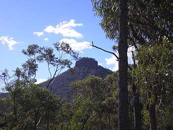

 The summit
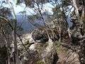
 View from the summit
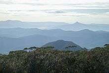 As seen from Mount Budawang, (Pigeon House on right horizon)
 The rare Pigeon House ash on Pigeon House Mountain