Grafton, New South Wales
| Grafton New South Wales | |||||||||
|---|---|---|---|---|---|---|---|---|---|
 Grafton Bridge across the Clarence River | |||||||||
 Grafton | |||||||||
| Coordinates | 29°41′0″S 152°56′0″E / 29.68333°S 152.93333°ECoordinates: 29°41′0″S 152°56′0″E / 29.68333°S 152.93333°E | ||||||||
| Population | 18,668 (2016)[1] | ||||||||
| Established | 1851 | ||||||||
| Postcode(s) | 2460 | ||||||||
| Elevation | 5 m (16 ft) | ||||||||
| Location | |||||||||
| LGA(s) | Clarence Valley Council | ||||||||
| County | Clarence | ||||||||
| State electorate(s) | Clarence | ||||||||
| Federal Division(s) | Page | ||||||||
| |||||||||
Grafton is a city in the Northern Rivers region of the Australian state of New South Wales. It is located on the Clarence River, approximately 500 kilometres (310 mi) north-northeast of the state capital Sydney. The closest major cities, Brisbane and the Gold Coast, are located across the border in South-East Queensland. According to the 2016 census, the Grafton "significant urban area" had a population of 18,668 people.[1] The city is the largest settlement and administrative centre of the Clarence Valley Council, which has over 50,000 people.
History
Before European settlement, the Clarence River marked the border between the Bundjalung[2] and Gumbaynggirr peoples, and so descendants of both language groups can now be found in the Grafton region.
Grafton, like many other settlements in the area, was first opened up to white settlement by the cedar-getters. An escaped convict, Richard Craig, discovered the district in 1831. With the wealth of 'red gold' cedar just waiting for exploitation, he was given a pardon and one hundred pounds to bring a party of cedar-getters on the cutter 'Prince George' to the region. Word of such wealth to be had did not take long to spread and one of the arrivals was pioneer John Small on the 'Susan' in 1838, and he first occupied land on Woodford Island. 'The Settlement' (as the embryonic Grafton was then imaginatively named) was established shortly after.
In 1851, Governor FitzRoy officially named the town "Grafton", after his grandfather, the Duke of Grafton, a former Prime Minister of the United Kingdom.[3] Grafton was proclaimed a city in 1885. Local industries include logging, beef cattle, fishing/prawning, sugar, manufacturing and tourism.
The Grafton Bridge, connecting the main townsite with South Grafton, opened in 1932. It completed the standard-gauge rail connection between Sydney and Brisbane, and also forming a vital link for the Pacific Highway. Previously the only way to travel from Grafton to South Grafton was via ferry. As a result, South Grafton developed quite a separate identity, and in fact had its own municipal government from 1896 to 1956.
Heritage listings
Grafton has a number of heritage-listed sites, including:
- Duke Street: Christ Church Cathedral[4]
- 170 Hoof Street: Grafton Correctional Centre[5]
- North Coast railway: Grafton Bridge[6]
- 95 Prince Street: Saraton Theatre[7]
- 150 Victoria Street: Arcola, Grafton[8]
Climate
Grafton has a humid subtropical climate with significantly more rainfall and higher temperatures in summer than in winter. Rainfall is lower than in stations directly on the coast, but monthly rain totals can often surpass 300 millimetres (12 in). The wettest month since records began was March 1974 when Cyclone Zoe produced a monthly total of 549.0 millimetres (21.61 in), whilst during periods of anticyclonic control and strong westerly winds monthly rainfall can be very low; for instance in August 2017 only 0.2 millimetres (0.01 in) fell. Grafton gets around 115.2 clear days on an annual basis. Grafton like many NSW regional centres, is affected by heatwaves in the summer months. On 12 February 2017 Grafton recorded a maximum temperature of 46.3, the town's highest recorded temperature since records began.[9]
| Climate data for Grafton | |||||||||||||
|---|---|---|---|---|---|---|---|---|---|---|---|---|---|
| Month | Jan | Feb | Mar | Apr | May | Jun | Jul | Aug | Sep | Oct | Nov | Dec | Year |
| Record high °C (°F) | 43.8 (110.8) |
46.3 (115.3) |
39.0 (102.2) |
36.7 (98.1) |
31.7 (89.1) |
30.5 (86.9) |
28.2 (82.8) |
36.3 (97.3) |
38.3 (100.9) |
39.3 (102.7) |
43.8 (110.8) |
43.4 (110.1) |
46.3 (115.3) |
| Average high °C (°F) | 30.1 (86.2) |
29.3 (84.7) |
28.3 (82.9) |
26.2 (79.2) |
23.1 (73.6) |
20.8 (69.4) |
20.5 (68.9) |
22.1 (71.8) |
24.8 (76.6) |
26.7 (80.1) |
28.1 (82.6) |
29.7 (85.5) |
25.8 (78.4) |
| Average low °C (°F) | 19.7 (67.5) |
19.7 (67.5) |
18.0 (64.4) |
14.9 (58.8) |
11.3 (52.3) |
8.1 (46.6) |
6.3 (43.3) |
7.3 (45.1) |
10.4 (50.7) |
13.7 (56.7) |
16.2 (61.2) |
18.4 (65.1) |
13.7 (56.7) |
| Record low °C (°F) | 12.8 (55) |
12.7 (54.9) |
10.8 (51.4) |
3.6 (38.5) |
0.5 (32.9) |
−2.0 (28.4) |
−2.2 (28) |
−0.2 (31.6) |
1.8 (35.2) |
3.9 (39) |
6.7 (44.1) |
7.0 (44.6) |
−2.2 (28) |
| Average rainfall mm (inches) | 138.9 (5.469) |
145.3 (5.72) |
129.8 (5.11) |
89.2 (3.512) |
81.8 (3.22) |
69.1 (2.72) |
39.2 (1.543) |
39.5 (1.555) |
36.7 (1.445) |
80.1 (3.154) |
104.4 (4.11) |
120.5 (4.744) |
1,074.5 (42.302) |
| Average rainy days (≥ 1.0 mm) | 10.7 | 11.0 | 11.1 | 8.0 | 7.7 | 5.7 | 4.6 | 4.3 | 5.3 | 7.4 | 9.3 | 10.1 | 95.2 |
| Average afternoon relative humidity (%) | 56 | 60 | 59 | 57 | 57 | 54 | 49 | 43 | 44 | 49 | 52 | 54 | 53 |
| Source #1: Bureau of Meteorology[10] | |||||||||||||
| Source #2: For February record high: Weatherzone[9] | |||||||||||||
Culture
Grafton is known and promoted as the Jacaranda City, in reference to its tree-lined streets and to the annual Jacaranda Festival. Inaugurated in 1935, Jacaranda is held each October/November. A half-day public holiday is observed locally on the first Thursday of November, the Festival's focal day.
A half-day public holiday is also observed for the Grafton Cup horse race, held each year on the second Thursday in July. It is the high point of the city's annual Racing Carnival—Australia's largest and richest non-metropolitan Carnival—which takes place over a fortnight in that month.
Grafton is the birthplace of several renowned country music players. Local artist Troy Cassar-Daley received four Golden Guitar awards at the 2006 Tamworth Country Music Awards—the largest and most prestigious country music awards in Australia. At the same event Samantha McClymont, the 2005/2006 Grafton Jacaranda Queen and sister of Brooke McClymont, also received an award for her country music talent.
A vision of Grafton with its numerous brilliantly-flowered trees in bloom is immortalised in Australian popular music in Cold Chisel's song Flame Trees, written by band member Don Walker, who had lived in Grafton during his formative years.
Notable buildings
Christ Church Cathedral, designed by John Horbury Hunt, was consecrated in 1884 and is the seat of the Anglican Diocese of Grafton.[11]
Schaeffer House is a historic 1900 Federation house and contains the collection of the Clarence River Historical Society, which was formed in 1931.[12]
Transportation
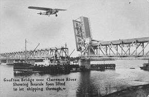
The Murwillumbah – Byron Bay – Lismore railway (opened in 1894) was extended to Grafton's original railway station in 1905;[13] for details, see Murwillumbah railway line. The North Coast Line reached South Grafton's railway station from Sydney in 1915. Pending the opening of the combined road and rail bascule bridge in 1932, Grafton had a train ferry to connect the two railways. Clarence Valley Regional Airport is the airport that services Grafton.
Grafton also lies on the Pacific Highway, the main North–South road route through Eastern Australia, and links it to the Gwydir Highway, one of the primary East-West routes through Eastern Australia.
Busways Grafton is the operator for local town routes, as well as out-of-town routes to Junction Hill, Jackadgery/Cangai, Copmanhurst, and Maclean and Yamba.
Lawrence Bus Service operates a shopper service, as well as school service on school days, to and from Lawrence.
Northern Rivers Buslines operates a weekday service to Lismore via Maclean, Evans Head and Coraki.
NSW TrainLink provides a coach service to Byron Bay, connecting off the train from Sydney. It also offers a coach service to Moree via Glen Innes, connecting from the train from Brisbane.
Industry
From 1904 to 1917 the Grafton Copper Mining Company Ltd operated a copper mine, smelter and tramway at Cangai,[14] more than 100 km from Grafton via the Clarence and Mann rivers, today about 70 km over the Gwydir Highway. From 1952 to 1997, first as an independent company, then owned by Tooheys since 1961, the Grafton brewery provided Grafton Bitter to the North Coast.[15] The nearby Harwood Mill is the oldest working sugar mill in New South Wales.
Newspapers
The daily newspaper of Grafton is The Daily Examiner, owned by media conglomerate Australian Provincial Newspapers (APN).
Radio and television
Radio stations
- 2GF 1206 AM/103.9 FM (commercial)
- FM 104.7 (commercial)
- Triple J 91.5 FM/96.1 FM
- ABC Northern Rivers 738 AM/94.5 FM
- ABC Classic FM 97.9 FM/95.3 FM
- Radio National 99.5 FM/96.9 FM
- Racing Radio 101.5 FM
- Life FM 103.1 (community)
- Raw FM 87.6
Television channels
- Prime7, 7TWO, 7mate, ishop tv, Racing.com, (Seven Network affiliated channels)
- Nine; 9Gem, 9Go!, 9Life, Extra, owned and operated by the (Nine Network)
- WIN Television; One, Eleven, (Network Ten affiliated channels)
- ABC Television including ABC, ABC2, ABC Me and ABC News 24, part of the Australian Broadcasting Corporation
- Special Broadcasting Service, SBS, SBS Viceland, Food Network and NITV
Pay television services are provided by Foxtel.
Of the three main networks, NBN produces an evening news bulletin containing regional, national and international news, screening every night at 6:00pm on Channel 9. Prime7 News produces a mid north coast new bulletin screening weeknights at 6:00pm. WIN Television produces news updates throughout the day, broadcast from the Wollongong studios.
Education
Public schools
- Gillwinga Public School
- Grafton High School
- Grafton Public School
- South Grafton High School
- South Grafton Public School
- Westlawn Public School
Independent schools
- Clarence Valley Anglican School (formerly The Cathedral School)[16]
- McAuley Catholic College
- St. Joseph's Primary School
- St. Mary's Primary School
- St. Andrew's Christian School
Defunct public schools A large number of small (mostly one-teacher) public schools existed in the Grafton and Clarence Valley areas in the past. These schools have included:
- Alumny Creek 1872–1969 [17]
- Angowrie 1895–1899
- Billys Creek 1946–1963
- Calliope 1890–1983
- Carr's Creek 1877–1964
- Clouds Creek 1943–1964
- Coalcroft 1875–1971 (originally known as Coaldale till 1912)
- Coldstream Lower 1873–1966
- Copmanhurst 1866–1938
- Eatonsville 1881–1961
- Glenferneigh 1928–1967
- Kungala 1926–1977
- Lawrence Lower 1883–1955
- Mororo 1886–1939
- Palmers Channel 1869–1975 (originally known as Taloumbi till 1907)
- Seelands 1889–1967
- Shark Creek 1877–1927
- Smalls Forest 1885–1971
- South Arm 1871–1967
- Southgate 1867–1875
- Stockyard Creek 1882–1895
- Swan Creek 1870–1994
- Trenayr 1901–1970 (originally known as Milers Waterholes till 1912)
- Tullymorgan 1886–1971 (originally known as Cormicks Creek till 1911)
- Tyndale 1868–1975
- Ulgundah Island Aboriginal 1908–1951 (near Maclean)
- Woodford Leigh 1869–1956
- Woombah 1872–1953
Military history
During World War 2, Grafton was the location of RAAF No.6 Inland Aircraft Fuel Depot (IAFD), completed in 1942 and closed on 29 August 1944. Usually consisting of 4 tanks, 31 fuel depots were built across Australia for the storage and supply of aircraft fuel for the RAAF and the US Army Air Forces at a total cost of £900,000 ($1,800,000).[18]
Notable residents
Notable people who were born or lived in Grafton include:
- James Armah (moved to Grafton in 2016) professional dual Commonwealth champion boxer
- Troy Cassar-Daley, Country musician
- Fanny Cohen (born 1887), headmistress[19]
- Matthew Colless (born 1960) astronomer [20] Professor Matthew Colless is the Director of the Research School of Astronomy and Astrophysics (RSAA) at the Australian National University(ANU). He was for nine years previously the Director of the Australian Astronomical Observatory (AAO), Australia's national optical observatory.[21]
- Peter Drysdale (born 1938), economist
- Adam Eckersley, musician
- Havelock Ellis (1859 – 1939), pioneer sexologist, held the position of assistant master at a local private grammar school during 1877.
- Nick Emmett, rugby league player
- James Eggins (1898–1952), politician
- Gary Foley (born 1950), Aboriginal activist, academic, writer
- Charles Hercules Green (1919–1950), officer
- George Green (1883–unknown), rugby league player
- Bill Hirschberg (1880–unknown), rugby union player
- Henry Kendall (18 April 1839 – 1 August 1882)
- Robyn Lambley (born 1965), politician
- Jimmy Lisle (1939–2003), rugby league and rugby union player
- Brent Livermore (born 5 July 1976), field hockey midfielder
- The McClymonts, country music group consisting of sisters Brooke, Samantha and Mollie
- Frank McGuren (1909–1990), politician
- Iven Giffard Mackay (7 April 1882 – 30 September 1966), Lieutenant General[3]
- Bill McLennan (born 1942), statistician
- Chris Masters (born 1948), journalist
- Gillian Mears (born 1964), author
- James Lionel Michael, poet and solicitor (moved to Grafton 1861, died in Grafton 1868)
- Tony Mundine (born 1951), boxer
- Warren Mundine (born 1956), politician
- Kevin Nichols (born 1955), track cyclist
- Sir Earle Page (8 August 1880 – 20 December 1961), Prime Minister of Australia, 1939
- Geoff Page (born 1940) Poet
- Ruby Payne-Scott (1912–1981), pioneer in radiophysics and radio astronomy
- Frank Partridge (1924–1964), recipient of the Victoria Cross
- Cameron Pilley (born 1982), squash player
- Eddie Purkiss (born 1934), rugby union player
- Tyrone Roberts (born 1 June 1991), Newcastle Knights footballer
- Michael Rush (1844-1921), rower
- Henry Ernest Searle (1866–1889), rower[3]
- Sir Grafton Elliot Smith (15 August 1871 – 1 January 1937), anatomist and palaeoanthropologist[3]
- Tse Tsan-tai (1872–1938), Chinese revolutionary[22]
- James Tully (1877–1962), politician
- William Edward Vincent (1823–1861), founded The Clarence and Richmond Examiner
- Brenda Walker (born 1957), writer
- Don Walker (born 1951), Musician
- Arthur Bache Walkom (1889–1976), palaeobotanist and museum director
- Bill Weiley (1901–1989), politician
- Danny Wicks (born 1985), rugby league player
- Graham Wilson, rugby league footballer of the 1960s
- Walter George Woolnough (1876–1958), geologist
- Beau Young (born 1974), singer-songwriter, surfer
References
- 1 2 2016 Census QuickStats
- ↑ Tindale, Norman (1974) "Badjalang" in his Catalogue of Australian Aboriginal Tribes. South Australian Museum Archived 2010-04-06 at the Wayback Machine.
- 1 2 3 4 "The romance of Australian place names". The Australian Women's Weekly. National Library of Australia. 27 May 1964. p. 59. Retrieved 14 October 2013.
- ↑ "Cathedral Church of Christ the King (inc. hall and cottages), New South Wales State Heritage Register (NSW SHR) Number H01654". New South Wales State Heritage Register. Office of Environment and Heritage. Retrieved 18 May 2018.
- ↑ "Grafton Correctional Centre, New South Wales State Heritage Register (NSW SHR) Number H00809". New South Wales State Heritage Register. Office of Environment and Heritage. Retrieved 18 May 2018.
- ↑ "Grafton rail and road bridge over Clarence River, New South Wales State Heritage Register (NSW SHR) Number H01036". New South Wales State Heritage Register. Office of Environment and Heritage. Retrieved 18 May 2018.
- ↑ "Saraton Theatre, New South Wales State Heritage Register (NSW SHR) Number H01401". New South Wales State Heritage Register. Office of Environment and Heritage. Retrieved 18 May 2018.
- ↑ "Arcola – house, stables, garden, fence, New South Wales State Heritage Register (NSW SHR) Number H00714". New South Wales State Heritage Register. Office of Environment and Heritage. Retrieved 18 May 2018.
- 1 2 Over 40 Temperature Records Broken over the Weekend by Joel Pippard, Weatherzone, 13 February 2017
- ↑ "Climate statistics for Grafton". Bureau of Meteorology. Retrieved 27 May 2013.
- ↑ Diocese of Grafton. "Grafton Cathedral". Retrieved 19 May 2006.
- ↑ About Us, Clarence River Historical Society
- ↑ Grafton—Rail Centre of the Clarence for 100 Years Milne, Rod Australian Railway Historical Society, November 2005, pp. 443–463
- ↑ "Assessment of Mineral Resources in the Upper North East CRA Study Area: A project undertaken as part of the NSW Comprehensive Regional Assessments November 1999". November 1999, New South Wales Government & Commonwealth Government. Retrieved on 6 May 2017.
- ↑ "Grafton fought hard to get a brewery" by Lachlan Thompson, The Daily Examiner, 29 October 2012
- ↑ "History of the Cathedral and the Close". Christ Church Cathedral Grafton. Retrieved 1 January 2014.
- ↑ Alumny Creek Public School 125th Anniversary 1872-1997
- ↑ Australia. Royal Australian Air Force. Historical Section (1995), Logistics units, AGPS Press, ISBN 978-0-644-42798-2
- ↑ "Cohen, Fanny (1887–1975)". Australian Dictionary of Biographies. 1981. Retrieved 30 March 2015.
- ↑ Colless, Matthew; Bhathal, Ragbir Singh) (Interviewer (21 March 2018). "Matthew Colless interviewed by Ragbir Bhathal in the Australian astronomers oral history project". Retrieved 21 March 2018 – via Trove.
- ↑ https://researchers.anu.edu.au/researchers/colless-mm
- ↑ "Grafton Chinese Who Led the revolution", The Sydney Morning Herald, 26 September 1932, via Trove
External links
| Wikimedia Commons has media related to Grafton, New South Wales. |
- Clarence Valley Council Website
- Clarence Valley Tourism Website
- Grafton, tropicalnsw.com.au
- Photographs of Grafton in 1994, National Library of Australia
- Jacaranda Festival Grafton
- Gillwinga Public School
- Grafton High School
- Grafton Public School
- South Grafton High School
- South Grafton Public School
- Westlawn Public School
- Clarence Valley Anglican School
- St Josephs Primary School
- St Mary's Primary School
- St. Andrew's Christian School
| Preceding station | NSW Main lines | Following station | ||
|---|---|---|---|---|
towards Border Loop | North Coast Line | towards Maitland |
||
| Preceding station | NSW TrainLink | Following station | ||
| NSW TrainLink North Coast | towards Sydney |
| Authority control |
|---|