Georgiana County

Georgiana
New South Wales
Location in New South Wales
Lands administrative divisions around Georgiana:
Bathurst Bathurst Westmoreland
King Georgiana Westmoreland
King Argyle Argyle

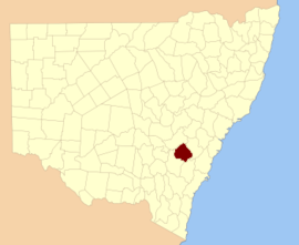
Georgiana County was one of the original Nineteen Counties in New South Wales and is now one of the 141 Cadastral divisions of New South Wales. It lies in the area about halfway between Bathurst and Goulburn. The Lachlan River is the western boundary, with the Crookwell River the southern boundary. It includes Bigga, and the area surrounding the Abercrombie River. It was part of the Electoral district of King and Georgiana from 1856 to 1859.

Georgiana County was named in honour of Georgiana Cavendish, Duchess of Devonshire (1757-1806).[1]

Parishes within this county

A full list of parishes found within this county; their current LGA and mapping coordinates to the approximate centre of each location is as follows:

ParishLGACoordinates
AbercrombieBathurst Regional Council33°54′54″S 149°15′04″E / 33.91500°S 149.25111°E / -33.91500; 149.25111 (Abercrombie)
BallyroeOberon Shire34°01′54″S 149°32′04″E / 34.03167°S 149.53444°E / -34.03167; 149.53444 (Ballyroe)
BeemarangOberon Shire33°54′54″S 149°44′04″E / 33.91500°S 149.73444°E / -33.91500; 149.73444 (Beemarang)
BelmoreUpper Lachlan Shire34°20′54″S 149°28′04″E / 34.34833°S 149.46778°E / -34.34833; 149.46778 (Belmore)
BiggaUpper Lachlan Shire34°02′54″S 149°09′04″E / 34.04833°S 149.15111°E / -34.04833; 149.15111 (Bigga)
BindaUpper Lachlan Shire34°20′54″S 149°24′04″E / 34.34833°S 149.40111°E / -34.34833; 149.40111 (Binda)
BinghamUpper Lachlan Shire34°03′54″S 149°30′04″E / 34.06500°S 149.50111°E / -34.06500; 149.50111 (Bingham)
BlackmanUpper Lachlan Shire34°07′54″S 149°16′34″E / 34.13167°S 149.27611°E / -34.13167; 149.27611 (Blackman)
BolongUpper Lachlan Shire34°14′24″S 149°35′04″E / 34.24000°S 149.58444°E / -34.24000; 149.58444 (Bolong)
BombahBathurst Regional Council33°55′54″S 149°20′04″E / 33.93167°S 149.33444°E / -33.93167; 149.33444 (Bombah)
BubalahlaUpper Lachlan Shire34°12′54″S 149°48′04″E / 34.21500°S 149.80111°E / -34.21500; 149.80111 (Bubalahla)
BucumbaOberon Shire33°53′54″S 149°28′04″E / 33.89833°S 149.46778°E / -33.89833; 149.46778 (Bucumba)
BummarooOberon Shire34°08′54″S 149°42′04″E / 34.14833°S 149.70111°E / -34.14833; 149.70111 (Bummaroo)
BurragaOberon Shire33°53′54″S 149°34′04″E / 33.89833°S 149.56778°E / -33.89833; 149.56778 (Burraga)
BurridgeeUpper Lachlan Shire34°07′54″S 149°32′04″E / 34.13167°S 149.53444°E / -34.13167; 149.53444 (Burridgee)
CarrawaBathurst Regional Council33°43′54″S 149°23′04″E / 33.73167°S 149.38444°E / -33.73167; 149.38444 (Carrawa)
CopperhanniaBathurst Regional Council33°50′54″S 149°15′04″E / 33.84833°S 149.25111°E / -33.84833; 149.25111 (Copperhannia)
CuddyongUpper Lachlan Shire34°13′54″S 149°25′04″E / 34.23167°S 149.41778°E / -34.23167; 149.41778 (Cuddyong)
FinleyOberon Shire34°03′54″S 149°42′04″E / 34.06500°S 149.70111°E / -34.06500; 149.70111 (Finley)
GarrynianOberon Shire33°58′54″S 149°45′04″E / 33.98167°S 149.75111°E / -33.98167; 149.75111 (Garrynian)
GillindichUpper Lachlan Shire34°11′24″S 149°19′34″E / 34.19000°S 149.32611°E / -34.19000; 149.32611 (Gillindich)
GilmandykeOberon Shire33°49′54″S 149°30′04″E / 33.83167°S 149.50111°E / -33.83167; 149.50111 (Gilmandyke)
GlengarryUpper Lachlan Shire34°08′54″S 149°04′04″E / 34.14833°S 149.06778°E / -34.14833; 149.06778 (Glengarry)
GrabineUpper Lachlan Shire33°55′54″S 149°05′34″E / 33.93167°S 149.09278°E / -33.93167; 149.09278 (Grabine)
GrovelandBathurst Regional Council33°48′54″S 149°26′04″E / 33.81500°S 149.43444°E / -33.81500; 149.43444 (Groveland)
GurnangOberon Shire34°00′54″S 149°49′04″E / 34.01500°S 149.81778°E / -34.01500; 149.81778 (Gurnang)
HillasUpper Lachlan Shire34°18′54″S 149°40′04″E / 34.31500°S 149.66778°E / -34.31500; 149.66778 (Hillas)
IsabellaOberon Shire33°57′54″S 149°41′04″E / 33.96500°S 149.68444°E / -33.96500; 149.68444 (Isabella)
JeremyOberon Shire33°59′54″S 149°35′04″E / 33.99833°S 149.58444°E / -33.99833; 149.58444 (Jeremy)
JerrongOberon Shire34°08′54″S 149°48′04″E / 34.14833°S 149.80111°E / -34.14833; 149.80111 (Jerrong)
JulongUpper Lachlan Shire34°16′54″S 149°17′04″E / 34.28167°S 149.28444°E / -34.28167; 149.28444 (Julong)
KangaloolahUpper Lachlan Shire34°07′54″S 149°23′04″E / 34.13167°S 149.38444°E / -34.13167; 149.38444 (Kangaloolah)
KempfieldBathurst Regional Council33°45′54″S 149°17′04″E / 33.76500°S 149.28444°E / -33.76500; 149.28444 (Kempfield)
KeverstoneUpper Lachlan Shire34°07′54″S 149°09′04″E / 34.13167°S 149.15111°E / -34.13167; 149.15111 (Keverstone)
KiammaUpper Lachlan Shire34°25′54″S 149°30′04″E / 34.43167°S 149.50111°E / -34.43167; 149.50111 (Kiamma)
LagganUpper Lachlan Shire34°20′54″S 149°35′04″E / 34.34833°S 149.58444°E / -34.34833; 149.58444 (Laggan)
LeighwoodUpper Lachlan Shire34°11′54″S 149°38′04″E / 34.19833°S 149.63444°E / -34.19833; 149.63444 (Leighwood)
MarkdaleUpper Lachlan Shire34°12′54″S 149°14′04″E / 34.21500°S 149.23444°E / -34.21500; 149.23444 (Markdale)
MegloUpper Lachlan Shire34°03′54″S 149°16′04″E / 34.06500°S 149.26778°E / -34.06500; 149.26778 (Meglo)
Mount LawsonOberon Shire33°50′54″S 149°34′04″E / 33.84833°S 149.56778°E / -33.84833; 149.56778 (Mount Lawson)
MulgowrieUpper Lachlan Shire34°14′54″S 149°09′04″E / 34.24833°S 149.15111°E / -34.24833; 149.15111 (Mulgowrie)
MulgunniaBathurst Regional Council33°48′54″S 149°21′04″E / 33.81500°S 149.35111°E / -33.81500; 149.35111 (Mulgunnia)
RetreatOberon Shire34°03′54″S 149°37′04″E / 34.06500°S 149.61778°E / -34.06500; 149.61778 (Retreat)
RockleyOberon Shire33°42′54″S 149°30′04″E / 33.71500°S 149.50111°E / -33.71500; 149.50111 (Rockley)
SherwoodUpper Lachlan Shire34°13′54″S 149°34′04″E / 34.23167°S 149.56778°E / -34.23167; 149.56778 (Sherwood)
StokeBathurst Regional Council33°54′54″S 149°10′04″E / 33.91500°S 149.16778°E / -33.91500; 149.16778 (Stoke)
ThalabaUpper Lachlan Shire34°16′54″S 149°30′04″E / 34.28167°S 149.50111°E / -34.28167; 149.50111 (Thalaba)
ThompsonUpper Lachlan Shire33°59′54″S 149°30′04″E / 33.99833°S 149.50111°E / -33.99833; 149.50111 (Thompson)
TuenaUpper Lachlan Shire34°01′54″S 149°23′04″E / 34.03167°S 149.38444°E / -34.03167; 149.38444 (Tuena)
Tyrl TyrlUpper Lachlan Shire34°26′54″S 149°38′04″E / 34.44833°S 149.63444°E / -34.44833; 149.63444 (Tyrl Tyrl)
WalbrookOberon Shire30°51′54″S 149°38′04″E / 30.86500°S 149.63444°E / -30.86500; 149.63444 (Walbrook)
WangaloUpper Lachlan Shire34°08′54″S 149°27′04″E / 34.14833°S 149.45111°E / -34.14833; 149.45111 (Wangalo)
WerongOberon Shire34°08′54″S 149°54′04″E / 34.14833°S 149.90111°E / -34.14833; 149.90111 (Werong)
WiarboroughUpper Lachlan Shire34°12′54″S 149°53′04″E / 34.21500°S 149.88444°E / -34.21500; 149.88444 (Wiarborough)
WowaginUpper Lachlan Shire34°19′54″S 149°46′04″E / 34.33167°S 149.76778°E / -34.33167; 149.76778 (Wowagin)
WyndhamOberon Shire34°04′54″S 149°44′34″E / 34.08167°S 149.74278°E / -34.08167; 149.74278 (Wyndham)
YalbraithUpper Lachlan Shire34°14′54″S 149°50′04″E / 34.24833°S 149.83444°E / -34.24833; 149.83444 (Yalbraith)
YarramanUpper Lachlan Shire33°55′54″S 149°16′04″E / 33.93167°S 149.26778°E / -33.93167; 149.26778 (Yarraman)
YewrangaraUpper Lachlan Shire34°02′54″S 149°04′04″E / 34.04833°S 149.06778°E / -34.04833; 149.06778 (Yewrangara)

References

  1. "Georgiana County". Geographical Names Register (GNR) of NSW. Geographical Names Board of New South Wales.
This article is issued from Wikipedia. The text is licensed under Creative Commons - Attribution - Sharealike. Additional terms may apply for the media files.