Belmore, New South Wales
| Belmore Sydney, New South Wales | |||||||||||||||
|---|---|---|---|---|---|---|---|---|---|---|---|---|---|---|---|
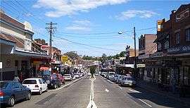 Burwood Road, Belmore | |||||||||||||||
|
Belmore | |||||||||||||||
| Coordinates | 33°55′3″S 151°5′16″E / 33.91750°S 151.08778°ECoordinates: 33°55′3″S 151°5′16″E / 33.91750°S 151.08778°E | ||||||||||||||
| Population | 12,718 (2016 census)[1] | ||||||||||||||
| Postcode(s) | 2192 | ||||||||||||||
| Location | 14 km (9 mi) south-west of Sydney CBD | ||||||||||||||
| LGA(s) | Canterbury-Bankstown Council | ||||||||||||||
| State electorate(s) | |||||||||||||||
| Federal Division(s) | |||||||||||||||
| |||||||||||||||
| Belmore within the Canterbury-Bankstown Council area |
Belmore is a suburb of Sydney, in the state of New South Wales, Australia. Belmore is located 14 kilometres south-west of the Sydney central business district, in the local government area of the Canterbury-Bankstown Council.
History
Belmore is named after the fourth Earl of Belmore, Governor of New South Wales from 1868-1872. The area was known as Darkwater in its early days. Some of the first land grants in 1810 were 40.5 hectares (100 acres) to Richard Robinson east of Sharp Street and Kingsgrove Road and 24 hectares (60 acres) to Thomas Mansfield, to the west. Francis Wild and John Sullivan were each granted 12 hectares (30 acres) in 1823. The area was originally used for market gardens and orchards. Subdivision started after the railway came through in 1895.[2]
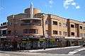
The first school, Belmore South Primary School opened on 25 April 1892 and the post office opened in 1907. The shopping centre began developing in the 1920s and features some classic examples of art-deco architecture.
Heritage listings
Belmore has a number of heritage-listed sites, including:
- Burwood Road: Belmore railway station[3]
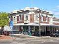
Commercial area
Belmore contains a mixture of residential, commercial and industrial developments. The main commercial area is located along Burwood Road, near Belmore railway station. Commercial and industrial developments are also located along Canterbury Road and surrounding streets.

Transport
Belmore railway station is located on the Bankstown Line of the Sydney Trains network. The line was opened in 1895 and electrified in 1926. The station at Belmore opened on 1 February 1895.
Churches
- All Saints Greek Orthodox Church
- St Alban's Anglican Church
- St Joseph's Catholic Church
- Belmore Church of Christ.
Schools
- Belmore South Public School
- Belmore North Public School
- Belmore Boys High School
- St Joseph's Primary School
- All Saints Grammar[4]
Gallery
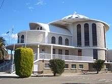 All Saints Greek Orthodox Church
 St Joseph's Catholic Church
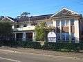 Belmore Boys High School
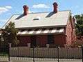
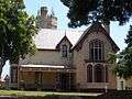 The Towers, a heritage-listed house in Forsyth Street[5]
Sport
Belmore Sports Ground is the home ground of the National Rugby League team Canterbury-Bankstown Bulldogs. It is the current home ground for New South Wales Premier League team Sydney Olympic. The "Back to Belmore" campaign was established in August 2005 to upgrade Belmore Sports Grounds as a top-class sporting facility to NRL standards for the Bulldogs to stage a select number of NRL games at their traditional home ground in the long-term future.
 Belmore Hotel
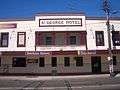 Belmore Brewery, St George Hotel
 Canterbury Leagues Club
Population
Demographics
Belmore is one of Australia's more ethnically diverse suburbs.
According to the 2016 census of Population, there were 12,718 residents in Belmore. 43.7% of residents were born in Australia, compared with the national average of 66.7%. The next most common countries of birth were Greece 6.3%, China 5.3%, Lebanon 4.1%, Vietnam 3.5% and South Korea 2.9%. 27.7% of people only spoke English at home. Other languages spoken at home included Greek 14.1%, Arabic 12.8%, Mandarin 4.6%, Vietnamese 4.4% and Korean 3.6%. The most common responses for religious affiliation were Catholic 24.1%, Eastern Orthodox 17.8%, No Religion 14.3% and Islam 12.9%.[1]
References
- 1 2 Australian Bureau of Statistics (27 June 2017). "Belmore (State Suburb)". 2016 Census QuickStats. Retrieved 16 March 2018.

- ↑ Pollen, Frances (1990). The Book of Sydney Suburbs. Australia: Angus & Robertson Publishers. p. 26. ISBN 0-207-14495-8.
- ↑ "Belmore Railway Station Group, New South Wales State Heritage Register (NSW SHR) Number H01081". New South Wales State Heritage Register. Office of Environment and Heritage. Retrieved 18 May 2018.
- ↑ All Saints Grammar
- ↑ State Heritage Register
External links
| Wikimedia Commons has media related to Belmore, New South Wales. |
- Lesley Muir and Brian Madden (2009). "Belmore". Dictionary of Sydney. Retrieved 25 September 2015. [CC-By-SA]
- City of Canterbury
- All Saints Grammar
- Back to Belmore - Back to the Future, Back to Basics