Fergus County, Montana
| Fergus County, Montana | |
|---|---|
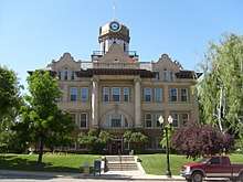 Fergus County Courthouse Lewistown | |
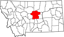 Location in the U.S. state of Montana | |
 Montana's location in the U.S. | |
| Founded | 1885 |
| Named for | James Fergus |
| Seat | Lewistown |
| Largest city | Lewistown |
| Area | |
| • Total | 4,350 sq mi (11,266 km2) |
| • Land | 4,340 sq mi (11,241 km2) |
| • Water | 11 sq mi (28 km2), 0.2% |
| Population (est.) | |
| • (2016) | 11,413 |
| • Density | 2.7/sq mi (1.0/km2) |
| Congressional district | At-large |
| Time zone | Mountain: UTC−7/−6 |
| Website |
www |
Fergus County is a county in the U.S. state of Montana. As of the 2010 census, the population was 11,586.[1] Its county seat is Lewistown.[2] The county was founded in 1885[3] and named for James Fergus, a Montana politician who was instrumental in creating the county (or, according to another source, John Fergus[4]).
Geography
According to the U.S. Census Bureau, the county has a total area of 4,350 square miles (11,300 km2), of which 4,340 square miles (11,200 km2) is land and 11 square miles (28 km2) (0.2%) is water.[5]
Adjacent counties
- Chouteau County, Montana – northwest
- Blaine County, Montana – north
- Phillips County, Montana – northeast
- Petroleum County, Montana – east
- Musselshell County, Montana – southeast
- Golden Valley County, Montana – south
- Wheatland County, Montana – southwest
- Judith Basin County, Montana – west
Major highways
National protected areas
Politics
| Year | Republican | Democratic | Third parties |
|---|---|---|---|
| 2016 | 73.1% 4,269 | 20.6% 1,202 | 6.3% 369 |
| 2012 | 70.1% 4,257 | 27.0% 1,640 | 2.9% 174 |
| 2008 | 65.9% 4,108 | 31.0% 1,933 | 3.1% 191 |
| 2004 | 72.2% 4,425 | 25.8% 1,582 | 2.0% 120 |
| 2000 | 72.6% 4,353 | 22.6% 1,352 | 4.8% 289 |
| 1996 | 59.3% 3,671 | 30.1% 1,866 | 10.6% 657 |
| 1992 | 42.2% 2,736 | 24.9% 1,615 | 33.0% 2,139 |
| 1988 | 64.6% 3,948 | 33.6% 2,052 | 1.9% 116 |
| 1984 | 71.0% 4,585 | 27.9% 1,804 | 1.1% 70 |
| 1980 | 65.0% 4,455 | 26.9% 1,840 | 8.1% 557 |
| 1976 | 57.7% 3,556 | 40.1% 2,470 | 2.2% 134 |
| 1972 | 67.5% 4,082 | 27.3% 1,652 | 5.2% 315 |
| 1968 | 55.6% 3,367 | 34.2% 2,070 | 10.2% 620 |
| 1964 | 47.4% 2,980 | 52.4% 3,300 | 0.2% 13 |
| 1960 | 52.2% 3,294 | 47.6% 2,999 | 0.2% 13 |
| 1956 | 57.8% 3,771 | 42.2% 2,757 | 0.0% 0 |
| 1952 | 65.8% 4,402 | 33.9% 2,271 | 0.3% 18 |
| 1948 | 42.7% 2,411 | 54.1% 3,059 | 3.2% 182 |
| 1944 | 41.1% 2,229 | 58.4% 3,164 | 0.5% 29 |
| 1940 | 40.9% 2,706 | 58.5% 3,873 | 0.6% 40 |
| 1936 | 27.0% 1,821 | 69.3% 4,675 | 3.7% 249 |
| 1932 | 33.6% 2,400 | 62.6% 4,470 | 3.7% 266 |
| 1928 | 60.1% 4,109 | 39.0% 2,667 | 0.9% 62 |
| 1924 | 38.5% 2,942 | 20.7% 1,580 | 40.8% 3,120 |
| 1920 | 60.2% 5,858 | 34.7% 3,371 | 5.1% 498 |
| 1916 | 34.9% 3,290 | 61.0% 5,749 | 4.1% 385 |
| 1912 | 20.3% 745 | 38.0% 1,393 | 41.6% 1,525[7] |
| 1908 | 52.4% 1,529 | 38.1% 1,112 | 9.4% 275 |
| 1904 | 63.2% 1,599 | 30.8% 780 | 5.9% 150 |
Demographics
| Historical population | |||
|---|---|---|---|
| Census | Pop. | %± | |
| 1890 | 3,514 | — | |
| 1900 | 6,937 | 97.4% | |
| 1910 | 17,385 | 150.6% | |
| 1920 | 28,344 | 63.0% | |
| 1930 | 16,531 | −41.7% | |
| 1940 | 14,040 | −15.1% | |
| 1950 | 14,015 | −0.2% | |
| 1960 | 14,018 | 0.0% | |
| 1970 | 12,611 | −10.0% | |
| 1980 | 13,076 | 3.7% | |
| 1990 | 12,083 | −7.6% | |
| 2000 | 11,893 | −1.6% | |
| 2010 | 11,586 | −2.6% | |
| Est. 2016 | 11,413 | [8] | −1.5% |
| U.S. Decennial Census[9] 1790–1960[10] 1900–1990[11] 1990–2000[12] 2010–2015[1] | |||
2000 census
As of the census[13] of 2000, there were 11,893 people, 4,860 households, and 3,197 families residing in the county. The population density was 3 people per square mile (1/km²). There were 5,558 housing units at an average density of 1 per square mile (0/km²). The racial makeup of the county was 97.10% White, 0.08% Black or African American, 1.18% Native American, 0.19% Asian, 0.29% from other races, and 1.16% from two or more races. 0.81% of the population were Hispanic or Latino of any race. 24.5% were of German, 13.5% American, 13.0% Norwegian, 9.3% Irish and 9.0% English ancestry. 97.1% spoke English, 1.2% German and 1.1% Spanish as their first language.
There were 4,860 households out of which 28.70% had children under the age of 18 living with them, 56.10% were married couples living together, 6.70% had a female householder with no husband present, and 34.20% were non-families. 30.50% of all households were made up of individuals and 13.90% had someone living alone who was 65 years of age or older. The average household size was 2.33 and the average family size was 2.91.
In the county, the population was spread out with 24.50% under the age of 18, 6.10% from 18 to 24, 23.60% from 25 to 44, 25.80% from 45 to 64, and 19.90% who were 65 years of age or older. The median age was 42 years. For every 100 females there were 94.80 males. For every 100 females age 18 and over, there were 93.40 males.
The median income for a household in the county was $30,409, and the median income for a family was $36,609. Males had a median income of $27,260 versus $18,138 for females. The per capita income for the county was $15,808. About 10.60% of families and 15.40% of the population were below the poverty line, including 19.40% of those under age 18 and 12.20% of those age 65 or over.
2010 census
As of the 2010 United States Census, there were 11,586 people, 5,099 households, and 3,202 families residing in the county.[14] The population density was 2.7 inhabitants per square mile (1.0/km2). There were 5,836 housing units at an average density of 1.3 per square mile (0.50/km2).[15] The racial makeup of the county was 96.6% white, 1.2% American Indian, 0.2% black or African American, 0.2% Asian, 0.2% from other races, and 1.5% from two or more races. Those of Hispanic or Latino origin made up 1.5% of the population.[14] In terms of ancestry, 30.8% were German, 15.9% were English, 14.7% were Norwegian, 12.8% were Irish, and 4.2% were American.[16]
Of the 5,099 households, 23.8% had children under the age of 18 living with them, 52.9% were married couples living together, 6.5% had a female householder with no husband present, 37.2% were non-families, and 32.6% of all households were made up of individuals. The average household size was 2.18 and the average family size was 2.75. The median age was 47.8 years.[14]
The median income for a household in the county was $37,607 and the median income for a family was $48,623. Males had a median income of $35,110 versus $21,225 for females. The per capita income for the county was $22,295. About 12.5% of families and 14.7% of the population were below the poverty line, including 24.2% of those under age 18 and 9.3% of those age 65 or over.[17]
Communities
City
- Lewistown (county seat)
Towns
Census-designated places
Other unincorporated communities
Notable residents
- Roy E. Ayers, member of the United States House of Representatives and 11th Governor of Montana, served as the attorney of the county from 1905 to 1909.[18]
- Carl W. Riddick, House of Representatives from the Second District of Montana, served as County Assessor of Fergus County.[19]
See also
| Wikimedia Commons has media related to Fergus County, Montana. |
References
- 1 2 "State & County QuickFacts". United States Census Bureau. Archived from the original on July 10, 2011. Retrieved September 15, 2013.
- ↑ "Find a County". National Association of Counties. Archived from the original on 2011-05-31. Retrieved 2011-06-07.
- ↑ "Fergus County - Home". www.co.fergus.mt.us. Retrieved 2018-04-02.
- ↑ Gannett, Henry (1905). The Origin of Certain Place Names in the United States. Govt. Print. Off. p. 125.
- ↑ "2010 Census Gazetteer Files". United States Census Bureau. August 22, 2012. Archived from the original on December 5, 2014. Retrieved November 28, 2014.
- ↑ Leip, David. "Dave Leip's Atlas of U.S. Presidential Elections". uselectionatlas.org. Retrieved 2018-04-02.
- ↑ The leading "other" candidate, Progressive Theodore Roosevelt, received 1,104 votes, while Socialist candidate Eugene Debs received 421 votes.
- ↑ "Population and Housing Unit Estimates". Retrieved June 9, 2017.
- ↑ "U.S. Decennial Census". United States Census Bureau. Archived from the original on May 12, 2015. Retrieved November 28, 2014.
- ↑ "Historical Census Browser". University of Virginia Library. Retrieved November 28, 2014.
- ↑ "Population of Counties by Decennial Census: 1900 to 1990". United States Census Bureau. Retrieved November 28, 2014.
- ↑ "Census 2000 PHC-T-4. Ranking Tables for Counties: 1990 and 2000" (PDF). United States Census Bureau. Retrieved November 28, 2014.
- ↑ "American FactFinder". United States Census Bureau. Archived from the original on 2013-09-11. Retrieved 2008-01-31.
- 1 2 3 "DP-1 Profile of General Population and Housing Characteristics: 2010 Demographic Profile Data". United States Census Bureau. Retrieved 2016-01-09.
- ↑ "Population, Housing Units, Area, and Density: 2010 – County". United States Census Bureau. Retrieved 2016-01-09.
- ↑ "DP02 SELECTED SOCIAL CHARACTERISTICS IN THE UNITED STATES – 2006–2010 American Community Survey 5-Year Estimates". United States Census Bureau. Retrieved 2016-01-09.
- ↑ "DP03 SELECTED ECONOMIC CHARACTERISTICS – 2006–2010 American Community Survey 5-Year Estimates". United States Census Bureau. Retrieved 2016-01-09.
- ↑ "Montana Governor Roy Elmer Ayers". National Governors Association. Retrieved October 14, 2012.
- ↑ "RIDDICK, Carl Wood, (1872–1960)". Biographical Directory of the United States Congress. Retrieved October 14, 2012.
Places adjacent to Fergus County, Montana | |
|---|---|
Municipalities and communities of Fergus County, Montana, United States | ||
|---|---|---|
| City | | |
| Towns | ||
| CDP | ||
| Other unincorporated communities | ||
| Ghost town | ||
| Indian reservation | ||
| Footnotes | ‡This populated place also has portions in an adjacent county or counties | |
