Puchheim
| Puchheim | ||
|---|---|---|
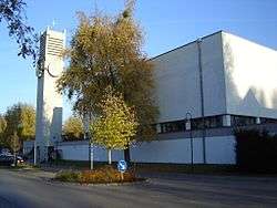 Saint Joseph Church | ||
| ||
 Puchheim Location of Puchheim within Fürstenfeldbruck district 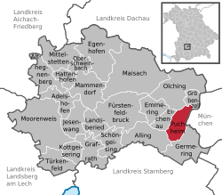 | ||
| Coordinates: 48°09′N 11°21′E / 48.150°N 11.350°ECoordinates: 48°09′N 11°21′E / 48.150°N 11.350°E | ||
| Country | Germany | |
| State | Bavaria | |
| Admin. region | Oberbayern | |
| District | Fürstenfeldbruck | |
| Government | ||
| • Mayor | Norbert Seidl (SPD) | |
| Area | ||
| • Total | 12.23 km2 (4.72 sq mi) | |
| Elevation | 535 m (1,755 ft) | |
| Population (2017-12-31)[1] | ||
| • Total | 21,396 | |
| • Density | 1,700/km2 (4,500/sq mi) | |
| Time zone | CET/CEST (UTC+1/+2) | |
| Postal codes | 82178 | |
| Dialling codes | 089 | |
| Vehicle registration | FFB | |
| Website | www.puchheim.de | |

Puchheim is a town near Munich in the district of Fürstenfeldbruck, in Bavaria, Germany. It has about 20,000 inhabitants.
Puchheim is divided into two parts: the old and rural part called Puchheim-Ort and the new part of Puchheim (Puchheim-Bahnhof) that was founded when the S-Bahn (a quick train commuting to Munich) was built. Before that there was one of the first civil airfields in Bavaria, which was later used as a prisoner of war camp during World War I.[2] The area around the camp was dried up by workers from the POW camp, so that houses could be built.
The old part of Puchheim is even older than Munich.
Puchheim is well connected to the regional and national traffic network by S-Bahn ![]()
References
- ↑ "Fortschreibung des Bevölkerungsstandes". Bayerisches Landesamt für Statistik und Datenverarbeitung (in German). September 2018.
- ↑ "Aus der Geschichte Puchheims". Stadt Puchheim (City of Puchheim). Retrieved 1 March 2014.
| Wikimedia Commons has media related to Puchheim. |
Towns and municipalities in Fürstenfeldbruck district | ||
|---|---|---|
This article is issued from
Wikipedia.
The text is licensed under Creative Commons - Attribution - Sharealike.
Additional terms may apply for the media files.