English River, Ontario
| English River | |
| Settlement | |
 | |
| Country | Canada |
|---|---|
| Province | Ontario |
| Region | Northwestern Ontario |
| Districts | Kenora, Thunder Bay |
| Elevation | 463 m (1,519 ft) |
| Coordinates | 49°13′36″N 90°57′56″W / 49.22667°N 90.96556°WCoordinates: 49°13′36″N 90°57′56″W / 49.22667°N 90.96556°W |
| Timezone | Central (UTC-6) |
| - summer (DST) | Central (UTC-5) |
| Area code | 807 |
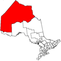
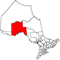
 Location of English River in Ontario | |
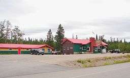
English River is an unincorporated place on the border of geographic Corman Township,[1] Kenora District and the Unorganized Part of Thunder Bay District in Northwestern Ontario, Canada.[2] It was a Hudson's Bay Company trading post between 1894 and 1911,[3] and is located where Ontario Highway 17 crosses the English River at its confluence with the Scotch River.
English River is also the name of a nearby railway point, 2 kilometres (1.2 mi) to the southwest and wholly within Corman Township, Kenora District (49°10′27″N 90°51′41″W / 49.17417°N 90.86139°W),[4] constructed as part of the Canadian Pacific Railway transcontinental main line.[5]
References
- ↑ "Corman" (PDF). Geology Ontario - Historic Claim Maps. Ontario Ministry of Northern Development, Mines and Forestry. Archived from the original (PDF) on 2016-03-04. Retrieved 2012-06-22.
- ↑ "English River". Geographical Names Data Base. Natural Resources Canada. Retrieved 2012-06-22. Infobox coordinates are from this reference.
- ↑ "English River". B. 371 (Beaver Lake Portage) to B.395 (Bucke). Hudson's Bay Company Archives. Retrieved 2012-06-22.
- ↑ "English River". Geographical Names Data Base. Natural Resources Canada. Retrieved 2012-06-22.
- ↑ "Railways – Ontario and Quebec" (Map). 1st Edition, 1906, Atlas of Canada. Natural Resources Canada. 1904. Archived from the original on 2012-07-11. Retrieved 2012-06-22.
Other map sources:
- Map 13 (PDF) (Map). 1 : 1,600,000. Official road map of Ontario. Ministry of Transportation of Ontario. 2012-01-01. Retrieved 2012-06-22.
- Restructured municipalities - Ontario map #1 (Map). Restructuring Maps of Ontario. Ontario Ministry of Municipal Affairs and Housing. 2006. Retrieved 2012-06-22.
This article is issued from
Wikipedia.
The text is licensed under Creative Commons - Attribution - Sharealike.
Additional terms may apply for the media files.