Whitesand, Ontario
| Whitesand | |
|---|---|
| Indian reserve | |
| Whitesand Indian Reserve | |
 Whitesand | |
| Coordinates: 50°19′N 89°02′W / 50.317°N 89.033°WCoordinates: 50°19′N 89°02′W / 50.317°N 89.033°W | |
| Country |
|
| Province |
|
| District | Thunder Bay |
| First Nation | Whitesand |
| Area[1] | |
| • Land | 8.26 km2 (3.19 sq mi) |
| Population (2011)[1] | |
| • Total | 260 |
| • Density | 31.5/km2 (82/sq mi) |
| Website | www.whitesandfirstnation.ca |
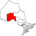
Whitesand is an Ojibwe First Nation reserve in northwestern Ontario. It serves as the land base for the Whitesand First Nation, alongside their settlement at Armstrong.
References
- 1 2 "Whitesand census profile". 2011 Census of Population. Statistics Canada. Retrieved 31 July 2015.
External links
Places adjacent to Whitesand, Ontario | |
|---|---|
This article is issued from
Wikipedia.
The text is licensed under Creative Commons - Attribution - Sharealike.
Additional terms may apply for the media files.