Neebing, Ontario
| Neebing | |
|---|---|
| Municipality (single-tier) | |
| Municipality of Neebing | |
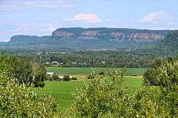 Rural scene of Neebing with the Nor'Wester Mountains in the background | |
 Neebing | |
| Coordinates: 48°11′N 89°28′W / 48.183°N 89.467°WCoordinates: 48°11′N 89°28′W / 48.183°N 89.467°W | |
| Country |
|
| Province |
|
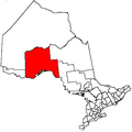
| District | Thunder Bay |
| Incorporated | 1881 |
| Government | |
| • Mayor | Zygmunt Polkowski |
| • Federal riding | Thunder Bay—Rainy River |
| • Prov. riding | Thunder Bay—Atikokan |
| Area[1] | |
| • Land | 877.60 km2 (338.84 sq mi) |
| Population (2011)[1] | |
| • Total | 1,986 |
| • Density | 2.3/km2 (6/sq mi) |
| Time zone | UTC-5 (EST) |
| • Summer (DST) | UTC-4 (EDT) |
| Forward sortation area | P7L |
| Area code(s) | 807 |
| Website | http://www.neebing.org |
Neebing is a municipality in the Canadian province of Ontario, located in the Thunder Bay District immediately south of the city of Thunder Bay. It is part of Thunder Bay's Census Metropolitan Area.
History
Neebing comprises the former geographic townships of Blake, Crooks, Pardee, Pearson and Scoble. It was incorporated in its current form on January 1, 1999. It should not be confused with the geographic township of Neebing, which was amalgamated into the City of Thunder Bay in 1970.
The Municipality of Neebing was incorporated in 1881 by the Legislative Assembly of Ontario. It included Neebing township, Neebing Additional township, Blake, Crooks and Pardee townships. In 1892 all of Neebing Additional township and a large portion of Neebing township was removed to form the City of Fort William. In 1970 the remainder of Neebing township was also removed from the Municipality of Neebing, leaving it with only the name.
Communities
The municipality includes the communities of Cloud Bay, Jarvis River, Moose Hill, Scoble West and Wamsley.
Demographics
| Canada census – Neebing, Ontario community profile | |||
|---|---|---|---|
| 2011 | 2006 | ||
| Population: | 1986 (-9.1% from 2006) | 2184 (6.6% from 2001) | |
| Land area: | 877.60 km2 (338.84 sq mi) | 875.51 km2 (338.04 sq mi) | |
| Population density: | 2.3/km2 (6.0/sq mi) | 2.5/km2 (6.5/sq mi) | |
| Median age: | 43.1 (M: 43.7, F: 42.1) | ||
| Total private dwellings: | 1096 | 1151 | |
| Median household income: | $70,139 | ||
| References: 2011[1] 2006[2] earlier[3] | |||
Population trend:[4]
- Population in 2011: 1986
- Population in 2006: 2184
- Population in 2001: 2049
- Population in 1996: 1021 (or 2102 when adjusted to 2001 boundaries)
- Land area: 641.03 square kilometres (247.50 sq mi)
- Population in 1991: 889
See also
References
- 1 2 3 "2011 Community Profiles". Canada 2011 Census. Statistics Canada. July 5, 2013. Retrieved 2012-03-29.
- ↑ "2006 Community Profiles". Canada 2006 Census. Statistics Canada. March 30, 2011. Retrieved 2011-04-28.
- ↑ "2001 Community Profiles". Canada 2001 Census. Statistics Canada. February 17, 2012.
- ↑ Statistics Canada: 1996, 2001, 2006 census
Places adjacent to Neebing, Ontario | |
|---|---|