Machin, Ontario
| Machin | |
|---|---|
| Township (single-tier) | |
| Township of Machin | |
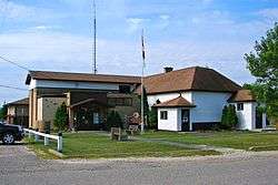 Township office in Vermilion Bay | |
 Machin | |
| Coordinates: 49°47′N 93°10′W / 49.783°N 93.167°WCoordinates: 49°47′N 93°10′W / 49.783°N 93.167°W | |
| Country |
|
| Province |
|
| District | Kenora |
| Government | |
| • Mayor | Drew Myers |
| • Federal riding | Kenora |
| • Prov. riding | Kenora—Rainy River |
| Area[1] | |
| • Land | 289.84 km2 (111.91 sq mi) |
| Population (2011)[1] | |
| • Total | 935 |
| • Density | 3.2/km2 (8/sq mi) |
| Time zone | UTC-6 (CST) |
| • Summer (DST) | UTC-5 (CDT) |
| Postal Code FSA | P0V |
| Area code(s) | 807 |
| Website | www.visitmachin.com |
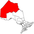
Machin is a township in the Canadian province of Ontario, located in the Kenora District west of Dryden.
The main communities in Machin township are Eagle River, Minnitaki, and Vermilion Bay. The junction of Highway 17 and Highway 105 is located in Machin, just east of Vermilion Bay.
 Minnitaki, Ontario
 Vermilion Bay, Ontario
Demographics
| Canada census – Machin, Ontario community profile | |||
|---|---|---|---|
| 2011 | 2006 | ||
| Population: | 935 (-4.4% from 2006) | 978 (-14.4% from 2001) | |
| Land area: | 289.84 km2 (111.91 sq mi) | 288.85 km2 (111.53 sq mi) | |
| Population density: | 3.2/km2 (8.3/sq mi) | 3.4/km2 (8.8/sq mi) | |
| Median age: | 47.0 (M: 48.5, F: 46.0) | 43.3 (M: 43.3, F: 43.3) | |
| Total private dwellings: | 560 | 481 | |
| Median household income: | $55,616 | ||
| References: 2011[1] 2006[2] earlier[3] | |||
- Population in 2001: 1143
- Population in 1996: 1117
- Population in 1991: 1127
See also
References
- 1 2 3 4 "2011 Community Profiles". Canada 2011 Census. Statistics Canada. July 5, 2013. Retrieved 2012-04-03.
- ↑ "2006 Community Profiles". Canada 2006 Census. Statistics Canada. March 30, 2011. Retrieved 2011-06-28.
- ↑ "2001 Community Profiles". Canada 2001 Census. Statistics Canada. February 17, 2012.
- ↑ Statistics Canada: Canada 1996 Census
External links
Places adjacent to Machin, Ontario | |
|---|---|
This article is issued from
Wikipedia.
The text is licensed under Creative Commons - Attribution - Sharealike.
Additional terms may apply for the media files.