Fort Severn First Nation
| Fort Severn 89 | |
|---|---|
| Indian reserve | |
| Fort Severn Indian Reserve No. 89 | |
 Fort Severn 89 | |
| Coordinates: 55°59′N 87°38′W / 55.983°N 87.633°WCoordinates: 55°59′N 87°38′W / 55.983°N 87.633°W | |
| Country |
|
| Province |
|
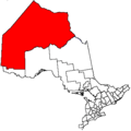
| District | Kenora |
| First Nation | Fort Severn |
| Area[1] | |
| • Land | 44.07 km2 (17.02 sq mi) |
| Population (2016)[2] | |
| • Total | 361 |
| • Density | 8.2/km2 (21/sq mi) |
| Website | fortsevern.firstnation.ca |
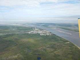
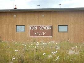
Fort Severn First Nation is a Cree First Nation band government located on Hudson Bay and is the most northern community in Ontario, Canada. In 2001, the population was 401, consisting of 90 families in an area of 40 square kilometres. The legal name of the reserve is Fort Severn 89, with the main settlement of Fort Severn.
The town is linked by winter/ice road called the Wapusk Trail the winter to Peawanuck, Ontario in the east, and Shamattawa and Gillam, Manitoba to the west.
Fort Severn is policed by the Nishnawbe-Aski Police Service, an Aboriginal-based service.
History
This area was inhabited for thousands of years by varying cultures of indigenous peoples. At the time of European contact, the historic Swampy Cree, an Algonquian-speaking people, lived in the area.
In 1689 the Hudson's Bay Company built Fort Severn at this site, originally naming it Fort James;[3] it was one of the earliest English fur trading posts in the New World. After years of international competition between the English and French, with their wars playing out in North America, the French attacked the outpost and pillaged it in 1782 when they were allies of the Thirteen Colonies during the American Revolutionary War.
In the early 20th century, when the federal government negotiated a treaty with the First Nations, it set aside land for a native reserve in the Rocksand area at the confluence of the Severn and Sachigo Rivers, with the consent of the leaders at the time. In 1973, the reserve was relocated to the mouth of the Severn River on Hudson Bay, for more direct access to shipping. The reserve achieved full status on January 11, 1980.
Government
The local band council consists of an elected chief, a deputy chief, and four band councilors.
Community services
There is no hospital in Fort Severn, with medical needs provided either at the local nursing station or via Keewaytinook Okimakanak Telemedicine (KOTM) link.[4]
Transportation
There are only local roads in town and residents travel by car, snowmobile or walking.
The Fort Severn Airport is located a short distance from the settlement and is accessible by an access road.
Education
Wasayo Cree Nation School is the only full functioning school providing primary education needs. It was built in 2016, preparing students for 21st century learning. Keewaytinook Internet High School is housed in a small building and provides distance learning for residents needing secondary education.[5]
References
- ↑ "Fort Severn 89 census profile". 2011 Census of Population. Statistics Canada. Retrieved 27 May 2015.
- ↑ "Fort Severn 89 census profile". 2016 Census of Population. Statistics Canada. Retrieved 20 May 2016.
- ↑ "Ontario Forts: page 4". www.northamericanforts.com. Retrieved 21 April 2018.
- ↑ "Telehealth and Telemedicine - Fort Severn First Nation". fortsevern.firstnation.ca. Retrieved 21 April 2018.
- ↑ "Fort Severn - Keewaytinook Internet High School". kihs1.knet.ca. Retrieved 21 April 2018.
Places adjacent to Fort Severn First Nation | ||||||||||
|---|---|---|---|---|---|---|---|---|---|---|
| ||||||||||